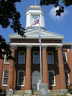
Clinton County is a county located in the U.S. state of Kentucky. As of the 2010 census, the population was 10,272. Its county seat is Albany. The county was formed in 1835 and named for DeWitt Clinton, the seventh Governor of New York. It is a prohibition or dry county.

Russell County is a county located in the U.S. Commonwealth of Kentucky. As of the 2010 census, the population was 17,565. Its county seat is Jamestown. The county was formed on December 14, 1825, from portions of Adair, Cumberland and Wayne Counties and is named for William Russell. It has been a prohibition or dry county, meaning that the sale of alcohol was prohibited, but in a referendum on Jan. 19, 2016, the county voted 3,833 to 3,423 to go "wet."

Owen County is a county located in the northern part of the U.S. state of Kentucky. As of the 2010 census, the population was 10,841. Its county seat is Owenton. The county is named for Colonel Abraham Owen. It is a prohibition or dry county, with the exception of a winery that is authorized to sell its product to the public, and limited sales within the incorporated city limits of Owenton.

Monroe County is a county located in the Pennyroyal Plateau region of the U.S. state of Kentucky. As of the 2010 census, the population was 10,963. Its county seat is Tompkinsville. The county is named for President James Monroe. It is a prohibition or dry county.

Greenup County is a county located along the Ohio River in the northeastern part of the U.S. state of Kentucky. As of the 2010 census, the population was 36,910. The county was founded in 1803 and named in honor of Christopher Greenup. Its county seat is Greenup. Greenup County is part of the Huntington-Ashland, WV-KY-OH Metropolitan Statistical Area.

White County is a county located in the U.S. state of Arkansas. As of the 2010 census, the population was 77,076. The county seat is Searcy. White County is Arkansas's 31st county, formed on October 23, 1835, from portions of Independence, Jackson, and Pulaski counties and named for Hugh Lawson White, a Whig candidate for President of the United States. It is an alcohol prohibition or dry county, though a few private establishments can serve alcohol.

Flatwoods is a home rule-class city in Greenup County, Kentucky, United States. Flatwoods is considered a suburb of nearby Ashland, although Ashland itself is located in neighboring Boyd County. The population of Flatwoods was 7,423 at the 2010 census, making Flatwoods the largest city in Greenup County. Flatwoods is a part of the Huntington-Ashland, WV-KY-OH, Metropolitan Statistical Area (MSA). As of the 2010 census, the MSA had a population of 287,702.

Russell is a home rule-class city on the south bank of the Ohio River in Greenup County, Kentucky, United States. The population was 3,380 as of the 2010 census, down from 3,645 in 2000. Russell is a suburb of Ashland and part of the Huntington-Ashland-Ironton metropolitan area. It has close economic affiliations with its neighbors, Ashland and Flatwoods in Kentucky and Ironton, Ohio.

Russell Springs is a home rule-class city in Russell County, Kentucky, in the United States. The city is the gateway to Lake Cumberland, one of the largest man-made lakes in the region, created by Wolf Creek Dam. It is the largest city in the county, having a population of 2,441 during the year 2010 U.S. Census.

UTC−05:00 is an identifier for a time offset from UTC of −05:00. In North America, it is observed in the Eastern Time Zone during standard time, and in the Central Time Zone during the other eight months. The western Caribbean uses it year round.

UTC−04:00 is an identifier for a time offset from UTC of −04:00. It is observed in the Eastern Time Zone during the warm months of daylight saving time, as Eastern Daylight Time. The Atlantic Time Zone observes it during standard time . It is observed all year in the Eastern Caribbean.

Somerset Community College (SCC) is a public community college in Somerset, Kentucky. It is part of the Kentucky Community and Technical College System (KCTCS). The college offers academic, general education, and technical curricula leading to certificates, diplomas, and associate's degrees. Somerset Community College is accredited by the Commission on Colleges of the Southern Association of Colleges and Schools (SACS).
State Road 62 (SR 62) in the U.S. state of Indiana is an east–west route that travels 204 miles (328 km) from the Illinois state line in the southwest corner of Indiana to the Louisville, Kentucky area, then northeast toward the Cincinnati, Ohio area.

Glens Fork is an unincorporated community located in Adair County, Kentucky, United States. Its elevation is 810 feet (247 m).

Gum Log Township is one of nineteen current townships in Pope County, Arkansas, USA. As of the 2010 census, its unincorporated population was 1,717.

Salt Gum is an unincorporated community within Knox County, Kentucky, United States.

Gum Tree is an unincorporated community located in Monroe County, Kentucky, United States. It is concentrated around the intersection of Kentucky Route 678, Kentucky Route 870, and Kentucky Route 1366, northwest of Tompkinsville, north of Gamaliel, west of Mud Lick, Kentucky, and east of Flippin, Kentucky. Gum Tree is home to one of Monroe County's voting precincts, which had over 900 registered voters as of 2014.
Gum Corners may refer to:


