Gyeonggi Province is the most populous province in South Korea.

Yongin is a city in the Seoul Capital Area, the largest in Gyeonggi Province, South Korea. With a population over 1 million, the city has developed rapidly since the 21st century, recording the highest population growth of any city in the country. Yongin is home to Everland and Caribbean Bay, South Korea's most popular amusement and water parks. The city is also home to the Korean Folk Village, the largest of its kind. Yongin is a multi-nuclear city with multiple urban centers, not a single nuclear structure, and Giheung District crosses the Yeongdong Expressway and Dongbaek, while Suji District crosses Pungdeokcheon Stream and Jukjeon.
Suwon is the largest city and capital of Gyeonggi Province, South Korea's most populous province. The city lies approximately 30 km (19 mi) south of the national capital, Seoul. With a population of 1.2 million, Suwon has more inhabitants than Ulsan, though it enjoys a lesser degree of self-governance as a 'special case city'.

Seongnam is the fourth largest city in South Korea's Gyeonggi Province after Suwon and the 10th largest city in the country. Its population is approximately one million. It consists of three administrative districts: Bundang District, Jungwon District, and Sujeong District.
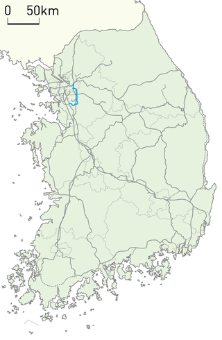
The Bundang Line or Seoul Metropolitan Subway Bundang Line was a commuter rail line of the Seoul Metropolitan Subway in the Seoul Capital Area operated by Korail. Also it refers physical railway track from Wangsimni to Suwon which is designated by MOLIT. The name 'Bundang Line' refers to the fact that the line was originally constructed for the new planned town of Bundang. The line service started in central eastern Seoul at Cheongnyangni, crossing Gangnam District and connecting the cities of Seongnam and Yongin, and terminates at Suwon Station. While the track 'Bundang Line' designated by MOLIT is from Wangsimni to Suwon.

The Shinbundang Line Korean: 신분당선; Hanja: 新盆唐線; literally, New Bundang Line) or DX Line for Dynamic Express Line is a 33.4 km (20.8 mi) long line of the Seoul Metropolitan Subway. It is the world's fifth subway to run completely driverless and the second completely driverless metro line to open in South Korea, after Busan Subway Line 4. It connects Sinsa station and Gwanggyo station in 42 minutes, a feat achieved by being the first line to operate South Korea's next-generation subway car travelling at over 90 km/h (56 mph), with the fastest average speed of any subway line in the country.

Tancheon is a stream in Gyeonggi Province and Seoul, South Korea. The stream is a tributary of the Han River. It begins in Yongin, Gyeonggi Province, flows through Seongnam, and eventually into the Han. It has a total length of 32.66 km (20.29 mi).

Pangyo or Pangyo New Town is a planned district composed of several dongs or neighborhoods of Seongnam, South Korea. It contains Pangyo-dong, Baekhyeon-dong, Unjung-dong, and Sampyeong-dong of Bundang-gu and Siheung-dong and Sasong-dong of Sujeong-gu.
Gumi-dong is one of the 19 dongs of Bundang District,, Seongnam, Gyeonggi Province. It has total area of 4.77 km2. As of April 30, 2006, there are 38,022 residents in Gumi-dong.

Jangan District, established on July 1, 1988, is the northern district of the city of Suwon in Gyeonggi Province, South Korea. It is approximately 15 km. from central Seoul.

Suwoncheon (Korean: 수원천) is a stream in South Korea. It is a tributary of the Hwanggujicheon, which in turn empties into the Yellow Sea at Asan Bay. Its source is on the slopes of Gwanggyosan on the border between Yongin and Suwon, from where it forms the Gwanggyo Reservoir. It then runs south and through Hwaseong's Hwahongmun to enter the old city of Suwon. It then runs through the centre of the old town and crosses the city walls once again near Paldalmun, crossing through Namsumun, a gate which was destroyed by a flood in 1922 and rebuilt in 2012. The stream has been covered for the rest of its journey through the city centre. On reemerging it then continues in a southerly direction before joining the Hwanggujicheon.

Jungbocheon (Korean: 중보천) is a stream in South Korea. It is a tributary of Hwanggujicheon, which in turn empties into the Yellow Sea at Asan Bay. Its source is Eupjang Reservoir, also known as Pajang Reservoir, near the North Suwon exit of the Yeongdong Expressway and at the bottom of the southwest slope of Gwanggyosan, on the border between Yongin and Suwon. It then flows south through the city of Suwon, being fed from the east by Ilwang Reservoir. It passes by Hwaseo Station and then forms Seoho, meaning West Lake. It then passes out of urban Suwon, still flowing south, till it joins the Hwanggujicheon.
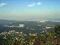
Bulgoksan (Korean: 불곡산) is a mountain in Gyeonggi Province, South Korea. Its area extends over the cities of Seongnam and Gwangju. Bulgoksan has an elevation of 345 m (1,132 ft). The mountain shares a name with another mountain in the Gyeonggi Province near Yangju.

Suji District, or Suji, is one of the three city districts in Yongin, South Korea which is approximately 29 km south of Seoul. Suji became a city district on October 31, 2005, about nine years after Yongin officially became a city. When Yongin was established in 1996, both urban and rural areas were covered to become a part of the city; thus to this day, Yongin's urbanization is varied throughout different regions of the city. Suji is one of the most urbanized areas of Yongin, as it borders Seongnam's Bundang District and Suwon, two more well developed areas. Home to the newly built Shinsegae Department Store and Dankook University in one of its towns, Jukjeon, Suji is rapidly developing as Yongin becomes more and more urbanized. In recent years, the district has attracted upper-class Koreans, with the completion of the Samsung East Palace in 2010.

Bundang (Korean: 분당) is a planned community in the Bundang District district of Seongnam, South Korea. It was developed to encourage affordable housing and urban decentralization. The community has a sports complex, a park and a youth center.
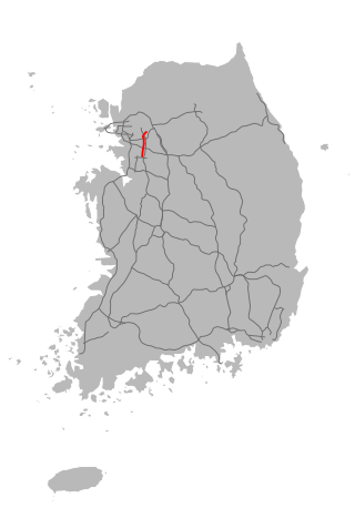
Yongin–Seoul Expressway is an expressway in South Korea, connecting Yongin, Gyeonggi and Gangnam-gu, Seoul. Informally known as the Gyeongsu Expressway(Korean: 경수고속도로), it is the only expressway in South Korea not directly connected to another expressway. Although it shares the same designation number, it is not directly connected to Osan-Hwaseong Expressway either. Plans have been made to connect the Busan side of Gyeongbu Expressway and Yongin-side Geumto Tollgate.

Gwanggyo refers to a planned city surrounding Yeongtong-gu of Suwon and Suji-gu of Yongin. Located about 25 km south of Seoul, Gwanggyo New Town has an area 11 square kilometers and was designated as such in 2004 by Gyeonggi Province, the city governments of Suwon and Yongin, and Gyeonggi Development Corp. (GICO). It will accommodate more than 31,000 households. In addition to increasing housing supply, Gwanggyo New Town also aims to achieve several other regional goals such as relocation of the provincial office, a new convention center, and creating a core for economic growth in Gyeonggi province. Its infrastructure was scheduled to be constructed by 2012.
Jeongja-dong (Korean: 정자동) is a group of three administrative neighbourhoods of Jangan-gu, Suwon, Gyeonggi Province, South Korea. Jeongja-dong (정자동/亭子洞) is also a legal status neighbourhood, though the administrative neighbourhoods' boundaries are wider. The three administrative neighbourhoods comprising Jeongja-dong are Jeongja-1-dong, Jeongja-2-dong, and Jeongja-3-dong. Jeongja-3-dong incorporates part of the legal status neighbourhood Cheoncheon-dong. Jeongja-dong is in central Jangan-gu, though it shares a short border with the city of Uiwang.