
Llanelli is a market town and community in Carmarthenshire and the preserved county of Dyfed, Wales. It is located on the Loughor estuary and is the largest town in the county of Carmarthenshire. The town is 11 miles (18 km) north-west of Swansea and 12 miles (19 km) south-east of Carmarthen. The town had a population of 25,168 in 2011, estimated in 2019 at 26,225. The local authority was Llanelli Borough Council when the county of Dyfed existed, but it has been under Carmarthenshire County Council since 1996.

Carmarthen is the county town of Carmarthenshire and a community in Wales, lying on the River Towy 8 miles (13 km) north of its estuary in Carmarthen Bay. The population was 14,185 in 2011, down from 15,854 in 2001, but gauged at 16,285 in 2019. It has a claim to be the oldest town in Wales – Old Carmarthen and New Carmarthen became one borough in 1546. It was the most populous borough in Wales in the 16th–18th centuries, described by William Camden as "chief citie of the country". Growth stagnated by the mid-19th century as new settlements developed in the South Wales Coalfield.

Ammanford is a town and community in Carmarthenshire, Wales, with a population of 5,411 at the 2011 census. It is a former coal mining town. The built-up area had a population of 7,945 with the wider urban area even bigger.

Llandovery is a market town and community in Carmarthenshire, Wales. It lies on the River Tywi and at the junction of the A40 and A483 roads, about 25 miles (40 km) north-east of Carmarthen, 27 miles (43 km) north of Swansea and 21 miles (34 km) west of Brecon.

Abergwili is a village and community in Carmarthenshire, Wales, near the confluence of the rivers Towy and Gwili, close to the town of Carmarthen. It is also an electoral ward. Named after the village of Abergwili, the community includes the settlements of Peniel, Llanfihangel-uwch-Gwili and White Mill. The grounds of the former Bishop's Palace are listed on the Cadw/ICOMOS Register of Parks and Gardens of Special Historic Interest in Wales.

Pencader is a small village in Carmarthenshire, Wales, in the community of Llanfihangel-ar-Arth. It is located around 3 miles (5 km) south-east of Llandysul and 6.5 miles (10 km) south-west of Llanybydder, in the valley of the Gwen brook, shortly before the confluence with the River Talog, to form the River Tyweli.

Llangain is a village and community in Carmarthenshire, in the south-west of Wales. Located to the west of the River Towy, and south of the town of Carmarthen, the community contains three standing stones, and two chambered tombs as well as the ruins of 15th century great house, Castell Moel. In 2001 the community's population was recorded at 574, decreasing slightly to 573 at the 2011 census.
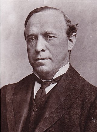
William Llewelyn Williams known as Llewelyn Williams, was a Welsh journalist, lawyer and radical Liberal Party politician.

Llanpumsaint is a village and community in Carmarthenshire, Wales. In the 2001 UK Census, Llanpumsaint community had a population of 595. It is not to be confused with Pumsaint, a small village some distance away on the River Cothi. The population increased in 2011 to 734, and thus the percentage of Welsh speakers declined.

Llangadog is a village and community in Carmarthenshire, Wales, which also includes the villages of Bethlehem and Capel Gwynfe. A notable local landscape feature is Y Garn Goch with two Iron Age hill forts.

Llangunnor is a village and community located in Carmarthenshire, Wales. It is the southern suburb of Carmarthen town and consists mainly of typical suburban housing which has expanded in recent years. It has a small shop, two chapels, a church and a Primary School. It is made up of the villages and hamlets of Nantycaws, Pensarn, Login and Pibwrlwyd.

Llangynog is a village and community located in Carmarthenshire, Wales, the main settlement of which was once called ‘Ebenezer’village. It is bordered by the communities of: Newchurch and Merthyr; Carmarthen; Llangain; Llansteffan; Laugharne Township; and St Clears, all being in Carmarthenshire. The population at the 2011 census was 492.
The office of High Sheriff of Dyfed was established in 1974 as part of the creation of the county of Dyfed in Wales following the Local Government Act 1972, and effectively replaced the shrievalties of the amalgamated counties of Cardiganshire, Carmarthenshire and Pembrokeshire. Since 1996 Dyfed has a purely ceremonial meaning, having been broken up for administrative purposes.
Capel Dewi is a small village in Carmarthenshire, Wales. The village is built on raised ground to the south of the River Towy, and to the east of the area's principal settlement Carmarthen. Originally a farming community, Capel Dewi has grown into a commuter village, serving Carmarthen and the surrounding area. Today it is part of the community of Llanarthney.

Llandissilio is a village and parish in the community of Llandissilio West in east Pembrokeshire, Wales on the A478 road between Efailwen to the north and Clunderwen to the south. A largely ribbon development along the main road, the village is surrounded by farmland.

Thomas Thomas was a Welsh church minister and chapel architect, also known as Thomas Glandŵr. He is described as "the first national architect of Wales" and the "unchallenged master of chapel architecture in Wales in the 1860s".

Glyntawe is a hamlet and parish on the upper reaches of the River Tawe in Powys, Wales, in the community of Tawe-Uchaf. It has always been sparsely populated. Today it attracts tourists for outdoor activities in the Brecon Beacons National Park and for caving.

Capel Heol Awst is an Independent Welsh chapel in the town of Carmarthen, Carmarthenshire, Wales. The present building dates from 1826 to 1827, replacing a 1726 building which itself had been enlarged in 1802 and again in 1826 to seat a congregation of 1000. It is located at 7 Friars Park, Carmarthen. It was designated as a Grade II* listed building on 19 May 1981.

Capel Heol Dŵr was a Calvinistic Methodist chapel in the town of Carmarthen, Carmarthenshire, Wales. The building dates from 1831 and is located at Water St, Carmarthen. It was designated as a Grade II listed building on 19 May 1981.

