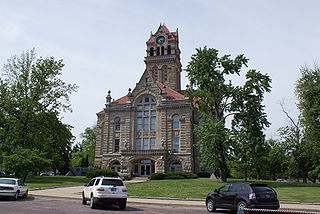
Starke County is a county in the U.S. state of Indiana. As of the 2020 United States Census, its population was 23,371. The county seat is Knox.
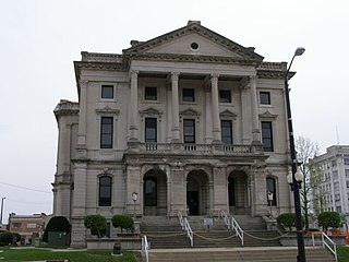
Grant County is a county in central Indiana in the United States Midwest. At the time of the 2020 census, the population was 66,674. The county seat is Marion. Important paleontological discoveries, dating from the Pliocene epoch, have been made at the Pipe Creek Sinkhole in Grant County.

Decatur Township is one of the nine townships in Marion County, Indiana, United States, and part of the consolidated city of Indianapolis. As of the 2020 census, it had a population of 36,951. Located in the southwest corner of the county, the township is home to the Indianapolis International Airport main terminal. It is one of the most rural sections of the county, but has seen many new residential and commercial developments. AmeriPlex, one of the largest industrial parks in Indiana, is in Decatur Township. Through the White River, Decatur and Perry townships share the only water boundary among Marion County's townships.

Richland Township is one of the twelve townships of Defiance County, Ohio, United States. The 2020 census found 3,063 people in the township.
Plumwood is a census-designated place in central Monroe Township, Madison County, Ohio, United States. It lies at the intersection of State Route 38 with Arthur Bradley Road, 8½ miles north of the city of London, the county seat of Madison County. The Spring Fork of the Little Darby Creek flows past the community.

Oakford is an unincorporated community in southwestern Taylor Township, Howard County, Indiana, United States.

Point Isabel is an unincorporated community and census-designated place (CDP) in central Green Township, Grant County, Indiana, United States. It lies at the intersection of State Roads 13 and 26. As of the 2010 census it had a population of 91.

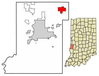
Pleasant Valley is an unincorporated community in Center Township, Martin County, in the U.S. state of Indiana.
Wheeler is an unincorporated census-designated place (CDP) in northern Union Township, Porter County, in the U.S. state of Indiana. It lies along State Road 130, northwest of the city of Valparaiso. Although Wheeler is unincorporated, it had a post office, with the ZIP code of 46393. The population of Wheeler was 443 at the 2010 census.

Velpen is an census-designated place in southeastern Marion Township, Pike County, in the U.S. state of Indiana. It lies along State Road 257 southeast of the city of Petersburg, the county seat of Pike County. Although Velpen is unincorporated, it has a post office, with the ZIP code of 47590.

Shepardsville is an unincorporated census-designated place in northeastern Fayette Township, Vigo County, in the U.S. state of Indiana. It lies along Trinity Ave. north of the city of Terre Haute, the county seat of Vigo County. Its elevation is 502 feet (153 m), and it is located at 39°36′3″N87°25′3″W. Although Shepardsville is unincorporated, it has a post office, with the ZIP code of 47880.

Rome is an unincorporated community along the Ohio River in southeastern Tobin Township, Perry County, in the U.S. state of Indiana.

Wadesville is a census designated place in northern Center Township, Posey County, in the U.S. state of Indiana. It lies along State Road 66 northeast of the city of Mt. Vernon, the county seat of Posey County. Although Wadesville is unincorporated, it has a post office, with the ZIP code of 47638.
Fontanet is an unincorporated census-designated place in central Nevins Township, Vigo County, in the U.S. state of Indiana. It lies along Baldwin St., northeast of the city of Terre Haute, the county seat of Vigo County. Its elevation is 614 feet (187 m), and it is located at 39°34′34″N87°14′37″W. Although Fontanet is unincorporated, it has a post office, with the ZIP Code of 47851.

Derby is an unincorporated community along the Ohio River in far southern Union Township, Perry County, in the U.S. state of Indiana. It lies at the intersection of State Roads 66 and 70 above the city of Tell City, the county seat of Perry County. Its elevation is 453 feet (138 m), and it is located at 38°1′49″N86°31′38″W. Although Derby is unincorporated, it has a post office, with the ZIP code of 47525.

East Enterprise is an unincorporated census-designated place in central Cotton Township, Switzerland County, in the U.S. state of Indiana. Although East Enterprise is unincorporated, it has a post office, with the ZIP code of 47019.

Butlerville is an unincorporated community and census-designated place (CDP) in central Campbell Township, Jennings County, Indiana, United States. As of the 2010 census it had a population of 282.
Bennington is an unincorporated community in central Pleasant Township, Switzerland County, in the U.S. state of Indiana. Although Bennington is unincorporated, it has a post office, with the ZIP code of 47011.

Ray is an unincorporated community in both Steuben County, Indiana and Branch County, Michigan in the United States. Located along the local "State Line Road," the small community straddles the border between the two states. The Indiana Northeastern Railroad travels southwest-northeast through Ray. Its elevation is 1,079 feet (329 m), making it the highest populated place in northern Indiana.

Pleasant Adams Hackleman was a lawyer, politician and Union general who was killed during the American Civil War.


