Jonesboro, Indiana

Last updated

City of Jonesboro, Indiana
Jonesboro water tower.jpg
Grant County Indiana Incorporated and Unincorporated areas Jonesboro Highlighted 1838862.svg
Location of Jonesboro in Grant County, Indiana.
Coordinates: 40°28′38″N85°37′36″W / 40.47722°N 85.62667°W / 40.47722; -85.62667
Country United States
State Indiana
County Grant
Government
  TypeMayor-council Government
   Mayor Bob Goins (R)[ citation needed ]
Area
[1]
  Total0.89 sq mi (2.31 km2)
  Land0.89 sq mi (2.31 km2)
  Water0.00 sq mi (0.00 km2)
Elevation
830 ft ( [2]  m)
Population
 (2020)
  Total1,516
  Density1,697.65/sq mi (655.57/km2)
Time zone UTC-5 (EST)
  Summer (DST) UTC-4 (EDT)
ZIP code
46938
Area code 765
FIPS code 18-38862 [3]
GNIS feature ID2395479 [2]
Website http://jonesboroindiana.net/
A Gazebo in Jonesboro, Indiana Gazebo in Jonesboro.jpg
A Gazebo in Jonesboro, Indiana

Jonesboro is a city in Grant County, Indiana, United States, located along the Mississinewa River opposite Gas City. The population was 1,756 at the 2010 census. According to the 2010 census, Jonesboro had the third smallest population of a city in Indiana.

Contents

History

Jonesboro was established in 1837 by Obadiah Jones, and named for him. [4]

Geography

According to the 2010 census, Jonesboro has a total area of 0.89 square miles (2.31 km2), all land. [5]

City government

Jonesboro City Hall Jonesboro City Hall.jpg
Jonesboro City Hall

The City is divided into 4 Wards, with a councilperson representing each ward and an additional councilperson at large. Citizens of Jonesboro also vote for their Clerk-Treasurer and City Attorney. The Mayor and the Council work together to govern the city.

Demographics

Historical population
CensusPop.Note
1850 288
1860 45457.6%
1870 58128.0%
1880 72925.5%
1890 687−5.8%
1900 1,838167.5%
1910 1,573−14.4%
1920 1,429−9.2%
1930 1,4964.7%
1940 1,79119.7%
1950 1,97310.2%
1960 2,26014.5%
1970 2,4669.1%
1980 2,279−7.6%
1990 2,073−9.0%
2000 1,887−9.0%
2010 1,756−6.9%
2020 1,516−13.7%
U.S. Decennial Census [6]

2010 census

As of the census [7] of 2010, there were 1,756 people, 684 households, and 486 families living in the city. The population density was 1,973.0 inhabitants per square mile (761.8/km2). There were 770 housing units at an average density of 865.2 per square mile (334.1/km2). The racial makeup of the city was 97.7% White, 0.1% African American, 0.5% Native American, 0.6% from other races, and 1.2% from two or more races. Hispanic or Latino of any race were 2.4% of the population.

There were 684 households, of which 34.9% had children under the age of 18 living with them, 49.6% were married couples living together, 14.9% had a female householder with no husband present, 6.6% had a male householder with no wife present, and 28.9% were non-families. 23.8% of all households were made up of individuals, and 9.2% had someone living alone who was 65 years of age or older. The average household size was 2.57 and the average family size was 2.94.

The median age in the city was 39 years. 25.8% of residents were under the age of 18; 8.2% were between the ages of 18 and 24; 24.4% were from 25 to 44; 26.9% were from 45 to 64; and 14.9% were 65 years of age or older. The gender makeup of the city was 48.5% male and 51.5% female.

2000 census

As of the census [3] of 2000, there were 1,887 people, 768 households, and 545 families living in the city. The population density was 2,221.8 inhabitants per square mile (857.8/km2). There were 817 housing units at an average density of 961.9 per square mile (371.4/km2). The racial makeup of the city was 97.51% White, 0.16% African American, 0.26% Native American, 0.05% Asian, 1.01% from other races, and 1.01% from two or more races. Hispanic or Latino of any race were 1.75% of the population.

There were 768 households, out of which 32.4% had children under the age of 18 living with them, 54.6% were married couples living together, 12.8% had a female householder with no husband present, and 29.0% were non-families. 25.0% of all households were made up of individuals, and 8.2% had someone living alone who was 65 years of age or older. The average household size was 2.46 and the average family size was 2.91.

In the city, the population was spread out, with 25.4% under the age of 18, 7.6% from 18 to 24, 29.4% from 25 to 44, 24.3% from 45 to 64, and 13.3% who were 65 years of age or older. The median age was 37 years. For every 100 females, there were 90.2 males. For every 100 females age 18 and over, there were 90.1 males.

The median income for a household in the city was $36,974, and the median income for a family was $42,036. Males had a median income of $33,611 versus $21,042 for females. The per capita income for the city was $16,723. About 4.1% of families and 6.5% of the population were below the poverty line, including 6.2% of those under age 18 and 5.6% of those age 65 or over.

Education

The city has a lending library, the Jonesboro Public Library. [8] The city has two schools, one public and one private. Westview Elementary School is an Elementary school for students from Pre-School to 1st Grade and is a part of the Mississinewa School Corporation, which also features R.J. Baskett, Northview Elementary School, and Mississinewa High School in neighboring Gas City, Indiana. The King's Academy is a K-12 Christian school affiliated with the ACSI.

Notable people

Related Research Articles

<span class="mw-page-title-main">Lake City, Arkansas</span> City in Arkansas, United States

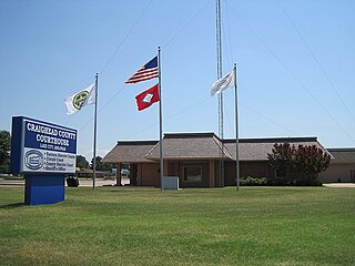
Lake City is a city in Craighead County, Arkansas, United States, along the St. Francis River. Lake City is one of two county seats in Craighead County. The population was 2,326 as of the 2020 census. It is included in the Jonesboro, Arkansas Metropolitan Statistical Area.

<span class="mw-page-title-main">Jonesboro, Illinois</span> City in Illinois, United States

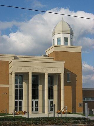
Jonesboro is a city in Union County, Illinois, United States. The population was 1,821 at the 2010 census, a decline from 1,853 in 2000. It is the county seat of Union County. The city is known for being tied to its close neighbor Anna, together known as Anna-Jonesboro.

<span class="mw-page-title-main">Charlestown, Indiana</span> City in Indiana, United States

Charlestown is a city located within Charlestown Township, in Clark County, Indiana, United States. The population was 7,775 at the 2020 census.

<span class="mw-page-title-main">Butler, Indiana</span> City in Indiana, United States

Butler is a city in DeKalb County, Indiana, United States. The population was 2,684 at the 2010 census.

<span class="mw-page-title-main">Albany, Indiana</span> Town in Indiana, United States

Albany is a town in Delaware and Randolph counties in the U.S. state of Indiana, along the Mississinewa River. The population was 2,295 at the 2020 census. It is part of the Muncie, IN Metropolitan Statistical Area.

<span class="mw-page-title-main">Daleville, Indiana</span> Town in Indiana, United States

Daleville is a town in Salem Township, Delaware County, Indiana, United States. The population was 1,651 at the 2020 census. It is part of the Muncie, IN Metropolitan Statistical Area.

<span class="mw-page-title-main">Eaton, Indiana</span> Town in Indiana, United States

Eaton is a town in Union Township, Delaware County, Indiana, along the Mississinewa River. The population was 1,595 at the 2020 census. It is part of the Muncie Metropolitan Statistical Area.

<span class="mw-page-title-main">Gas City, Indiana</span> City in Indiana, United States

Gas City is a city in Grant County, Indiana, United States, along the Mississinewa River. The population was 5,965 at the 2010 census.

<span class="mw-page-title-main">Matthews, Indiana</span> Town in Indiana, United States

Matthews is a town in Jefferson Township, Grant County, Indiana, United States, along the Mississinewa River. The population was 596 at the 2010 census.

<span class="mw-page-title-main">Jasonville, Indiana</span> City in Indiana, United States

Jasonville is a city in Greene County, Indiana, United States. The population was 1,966 as of the 2020 census. It is the westernmost community in the Bloomington, Indiana, Metropolitan Statistical Area, approximately 15 miles closer to Terre Haute than to Bloomington.

<span class="mw-page-title-main">Warren, Indiana</span> Town in Indiana, United States

Warren is a town in Salamonie Township, Huntington County, Indiana. The population of Warren was 1,182 at the time of the 2020 census.

<span class="mw-page-title-main">Syracuse, Indiana</span> Town in Indiana, United States

Syracuse is a town in Turkey Creek Township, Kosciusko County, in the U.S. state of Indiana. The population was 3,079 at the 2020 census. Syracuse is the location of Lake Syracuse and the nearby, larger Lake Wawasee, in addition to several other lakes in the region. The National Weather Service operates a Weather Forecast Office South of town, toward North Webster. It serves Northern Indiana.

<span class="mw-page-title-main">Ridgeville, Indiana</span> Town in Indiana, United States

Ridgeville is a town in Franklin Township, Randolph County, Indiana, United States, along the Mississinewa River. The population was 688 at the 2020 census.

<span class="mw-page-title-main">Winchester, Indiana</span> City in Indiana, United States

Winchester is a city in White River Township, Randolph County, in the U.S. state of Indiana. The city is the county seat of Randolph County. The population was 4,935 at the 2010 census. It is the home of Winchester Speedway.

<span class="mw-page-title-main">Columbia City, Indiana</span> City in Indiana, United States

Columbia City is a city in Columbia Township, Whitley County, in the U.S. state of Indiana. The population was 9,892 at the 2020 Census, up from 8,750 at the 2010 Census, estimated to be 10,064 in 2023. The city is the county seat of Whitley County, and is the largest community therein. It is part of the Fort Wayne MSA.

<span class="mw-page-title-main">Dedham, Iowa</span> City in Iowa, United States

Dedham is a city in Carroll County, Iowa, United States. The population was 224 at the time of the 2020 census.

Jonesboro is a town in Washington County, Maine, United States. The town was named for John Coffin Jones, a landholder. The population was 587 at the 2020 census.

<span class="mw-page-title-main">Bennington, Nebraska</span> City in Douglas County, Nebraska, United States

Bennington is a city in Douglas County, Nebraska, United States. The population was 2,026 at the 2020 U.S. Census.

<span class="mw-page-title-main">St. Bonifacius, Minnesota</span> City in Minnesota, United States

Saint Bonifacius, often stylized as St. Bonifacius, is a small city in Hennepin County, Minnesota, United States, 25 miles west of Minneapolis. Settled in the 1850s, the town has a combination of rural and exurban features. It is completely surrounded by Minnetrista, Minnesota, and is close to the county line with Carver County. It hosted a Nike Hercules battery during the Cold War, one of four protecting Minneapolis–Saint Paul from Soviet bombers.

<span class="mw-page-title-main">Parma, New York</span> Town in New York, United States

Parma is a town in Monroe County, New York, United States. The population was 16,217 at the 2020 census.

References

  1. "2020 U.S. Gazetteer Files". United States Census Bureau. Retrieved March 16, 2022.
  2. 1 2 U.S. Geological Survey Geographic Names Information System: Jonesboro, Indiana
  3. 1 2 "U.S. Census website". United States Census Bureau . Retrieved January 31, 2008.
  4. Couch, Ernie (October 25, 2000). Indiana Trivia. Thomas Nelson Inc. p. 27. ISBN   978-1-4185-7362-1.
  5. "G001 - Geographic Identifiers - 2010 Census Summary File 1". United States Census Bureau. Archived from the original on February 13, 2020. Retrieved July 28, 2015.
  6. "Census of Population and Housing". Census.gov. Retrieved June 4, 2015.
  7. "U.S. Census website". United States Census Bureau . Retrieved December 11, 2012.
  8. "Indiana public library directory" (PDF). Indiana State Library. Archived from the original (PDF) on February 18, 2017. Retrieved March 7, 2018.