
Indiana County is a county in the Commonwealth of Pennsylvania. It is located in the west central part of Pennsylvania. As of the 2020 census, the population was 83,246. Its county seat is Indiana. Indiana County comprises the Indiana, PA Micropolitan Statistical Area, which is also included in the Pittsburgh-New Castle-Weirton, PA-WV-OH Combined Statistical Area.

Huntington County is a county in the U.S. state of Indiana. According to the 2020 United States Census, the population was 36,662. The county seat is Huntington.

Howard County is one of 92 counties in the U.S. state of Indiana. As of the 2020 census, the population was 83,658. The county seat is Kokomo. Originally named Richardville County, it was renamed in 1844 to commemorate General Tilghman Ashurst Howard.
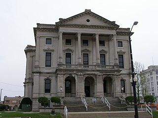
Grant County is a county in central Indiana in the United States Midwest. At the time of the 2020 census, the population was 66,674. The county seat is Marion. Important paleontological discoveries, dating from the Pliocene epoch, have been made at the Pipe Creek Sinkhole in Grant County.

Grant Township is one of eleven townships in Benton County, Indiana. As of the 2020 census, its population was 1,085 and it contained 470 housing units. It was organized in December 1868 and was named for Ulysses Grant.

Hickory Grove Township is one of eleven townships in Benton County, Indiana. As of the 2020 census, its population was 398 and it contained 168 housing units. It was organized in March 1876 and named for a grove of hickory trees that grew within its borders in the 19th century.
Oak Grove Township is one of eleven townships in Benton County, Indiana. As of the 2020 census, its population was 1,551 and it contained 690 housing units. It was one of the first three townships originally created by the county's commissioners in 1840. It takes its name from White Oak Grove which grew southwest of Oxford.

Richland Township is one of eleven townships in Benton County, Indiana. As of the 2020 census, its population was 562 and it contained 258 housing units. Its name is a "reference to the rich land within its borders."

Grant Township is one of ten townships in Newton County, Indiana, United States. As of the 2010 census, its population was 1,189 and it contained 548 housing units.

Wilmington Township is one of fifteen townships in DeKalb County, Indiana. As of the 2010 census, its population was 4,128 and it contained 1,623 housing units.

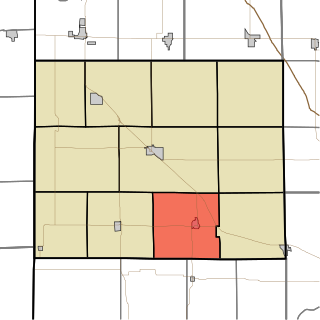
Liberty Township is one of thirteen townships in Grant County, Indiana, United States. As of the 2010 census, its population was 1,028 and it contained 428 housing units.

Clarksburg is an unincorporated community and census-designated place in Fugit Township, Decatur County, Indiana, United States. As of the 2010 census, the population of Clarksburg was 149.

Herbst is an unincorporated census-designated place in Franklin Township, Grant County, Indiana, in the United States. As of the 2010 census, the population was 112.

Jalapa is an unincorporated community and census-designated place (CDP) in Pleasant Township, Grant County, Indiana, United States. As of the 2010 census it had a population of 171. The site of the Battle of the Mississinewa, fought during the War of 1812, is nearby.
Rigdon is an unincorporated community in Grant and Madison counties, Indiana, United States.

Sims is an unincorporated community and census-designated place (CDP) in Sims Township, Grant County, Indiana. In 2010 it had a population of 156.

Indiana is a U.S. state in the Midwestern United States. It is the 38th-largest by area and the 17th-most populous of the 50 States. Its capital and largest city is Indianapolis. Indiana was admitted to the United States as the 19th state on December 11, 1816. It is bordered by Lake Michigan to the northwest, Michigan to the north and northeast, Ohio to the east, the Ohio River and Kentucky to the south and southeast, and the Wabash River and Illinois to the west.

Landess is an unincorporated community and census-designated place (CDP) in Washington and Van Buren townships, Grant County, Indiana, in the United States. As of the 2010 census it had a population of 188.

Mier is an unincorporated community and census-designated place (CDP) in Richland Township, Grant County, Indiana, in the United States. As of the 2010 census it had a population of 78.


