Kurwai is a town and a Nagar Panchayat in Vidisha district in the Indian state of Madhya Pradesh.
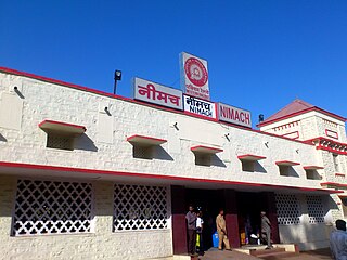
Neemuch or Nimach is a town in the malwa region. Neemuch crowns the north western part of MP. It has been also referred to city of Nature and Peace. The town shares its northwestern border with the state of Rajasthan and is the administrative headquarters of Neemuch District. Formerly a large British cantonment of Gwalior princely state, in 1822 the town became the headquarters of the combined Rajputana–Malwa political agency and of the Malwa Agency in 1895. The British Cantonment was disbanded in 1932 after which it was maintained by a British Municipal Board.
Pataudi is a town and one of the 4 sub-divisions of Gurugram district, in the Indian state of Haryana, within the boundaries of the National Capital Region of India. It is located 28 km (17.4 mi) from Gurugram, at the foot hills of the Aravali hills.
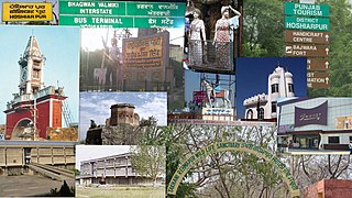
Hoshiarpur is a city and a municipal corporation in Hoshiarpur district in the Doaba region of the Indian state of Punjab. It was founded, according to tradition, during the early part of the fourteenth century. In 1809, it was occupied by the forces of Maharaja Karanvir Singh and was united into the greater state of Punjab in 1849.
Nalagarh is a city and a municipal committee, near the city of Solan in Solan district in the Indian state of Himachal Pradesh.
Phillaur is a city and a municipal council as well as a tehsil in Jalandhar district in the Indian state of Punjab.
Adampur is a town, a municipal council and a sub-tehsil in Jalandhar district in the Indian state of Punjab.
Bhawani Mandi is a town and a municipality in Jhalawar district in the state of Rajasthan, India.
Jakhal Mandi is a city and a municipal council, near Fatehabad town in Fatehabad district in the Indian state of Haryana.
Kolvi Mandi Rajendra pura is a census town in Jhalawar district in the Indian state of Rajasthan.it is also a beautiful town.there are many of temples.
Kot Fatta is a city and a municipal council in Bathinda district in the Indian state of Punjab.
Obedullaganj is a town and a nagar panchayat in Raisen district in the Indian state of Madhya Pradesh. It is situated 70 km from its district headquarter Raisen and 36 km from its state capital city Bhopal.
Piplia Mandi is a town and a Nagar Parishad in Mandsaur district in the Indian state of Madhya Pradesh. It is15 km away from the city of Mandsaur on state highway 31.
Ramganj Mandi is a city and a municipality in Kota district in the Indian state of Rajasthan. It is known as stone city, coriander city. It has the largest grain market of coriander with around 6500 tons of coriander seeds arriving on a single day during season. Spices Giant MDH buys its coriander seeds from Ramganj Mandi. A new spice park is being constructed on Nimana road, the link road between SH 9B and NH 12. Annually billions of square feet of limestone is exported throughout the country, mainly in Punjab, Haryana, Chandigarh, Gujarat, Maharashtra and Madhya Pradesh. Around 1000 stone processing units are set up in the industrial area. More than 80 mines are present in the area.
Sanaur is a town and a municipal council in Patiala in the Indian state of Punjab.
Sangat is a Suburb town of Bathinda City and a municipal council in Bathinda district in the Indian state of Punjab. Sangat Mandi is situated 20 km (12 mi) away from Bathinda District headquarter in south. Sangat is Small commercial hub of area.
Tapa is a small town or city and a municipal council and administrative area in Barnala district in the Indian state of Punjab. Tapa is mainly known as Tapa-Mandi because Mandi word can be translated as grain market. As Tapa has been very famous for its grain market, many people from near villages come here to sell their crops and grains. This has been the main source of income and job opportunities for many people around this area. Tapa is well known for its historic Deras and Guruduwaras and for best economy in its district. A famous holy place named as Baba Math -, is the main attraction of this town. Tapa is situated at Barnala-Bathinda Main Road between Barnala and Bathinda, Moga and Mansa. It is 24 km towards Bathinda from Barnala and 42 km towards Barnala from Bathinda. Moga Road also passes through it towards Pakho-Kenchian.

Thanamandi is a town and a municipal committee in the Rajouri district in the Indian union territory of Jammu and Kashmir. Thanamandi lies on the Mughal Road between Rajouri and Bufliaz. The municipal area limits are mostly inhabitated by kashmiris.
Uchana is a developing town and a municipal committee, near city of Jind in Jind district in the Indian state of Haryana.

NurMahal or Noor Mahal is a city and a municipal council in Jalandhar district in the Indian state of Punjab. It is a small town located near the Lohian Khas-Nakodar - Phillaur line in Punjab. This town is also connected with the nearby towns of Phillaur and Nakodar by a road going along the railway lines. Nurmahal is situated 13 km from Nakodar, 33 km from Jalandhar. Many villages are close by to Nurmahal.


