Hale, Wisconsin

Last updated

Hale, Wisconsin
WIMap-doton-Hale.png
Location of Hale, Wisconsin
Coordinates: 44°28′28″N91°18′20″W / 44.47444°N 91.30556°W / 44.47444; -91.30556
Country Flag of the United States.svg  United States
State Flag of Wisconsin.svg  Wisconsin
County Trempealeau
Area
  Total69.7 sq mi (180.6 km2)
  Land69.7 sq mi (180.5 km2)
  Water0.0 sq mi (0.1 km2)
Elevation
[1]
886 ft (270 m)
Population
 (2000)
  Total988
  Density14.2/sq mi (5.5/km2)
Time zone UTC-6 (Central (CST))
  Summer (DST) UTC-5 (CDT)
FIPS code 55-32050 [2]
GNIS feature ID1583334 [1]

Hale is a town in Trempealeau County, Wisconsin, United States. The population was 988 at the 2000 census. The unincorporated communities of Elk Creek, Hale, and Pleasantville are located in the town.

Contents

Geography

According to the United States Census Bureau, the town has a total area of 69.7 square miles (180.6 km2), of which, 69.7 square miles (180.5 km2) of it is land and 0.04 square miles (0.1 km2) of it (0.04%) is water.

Demographics

As of the census [2] of 2000, there were 988 people, 354 households, and 288 families residing in the town. The population density was 14.2 people per square mile (5.5/km2). There were 380 housing units at an average density of 5.5 per square mile (2.1/km2). The racial makeup of the town was 98.28% White, 0.10% African American, 0.61% Native American, 0.20% Asian, 0.20% from other races, and 0.61% from two or more races. Hispanic or Latino of any race were 0.81% of the population.

There were 354 households, out of which 37.6% had children under the age of 18 living with them, 69.2% were married couples living together, 4.2% had a female householder with no husband present, and 18.6% were non-families. 14.1% of all households were made up of individuals, and 5.9% had someone living alone who was 65 years of age or older. The average household size was 2.79 and the average family size was 3.04.

In the town, the population was 28.0% under the age of 18, 5.9% from 18 to 24, 29.8% from 25 to 44, 25.3% from 45 to 64, and 11.0% who were 65 years of age or older. The median age was 37 years. For every 100 females, there were 108.4 males. For every 100 females age 18 and over, there were 113.5 males.

The median income for a household in the town was $42,589, and the median income for a family was $44,375. Males had a median income of $27,500 versus $19,919 for females. The per capita income for the town was $17,262. About 5.8% of families and 5.5% of the population were below the poverty line, including 4.1% of those under age 18 and 15.9% of those age 65 or over.

44°27′57″N91°15′45″W / 44.46583°N 91.26250°W / 44.46583; -91.26250

Related Research Articles

<span class="mw-page-title-main">Sylvania, Alabama</span> Town in Alabama, United States

Sylvania is a town in DeKalb County, Alabama, United States. It incorporated in October 1967. At the 2010 census the population was 1,837, up from 1,186 in 2000. Sylvania is located atop Sand Mountain. Sylvania was incorporated in 1967. The post office /town hall was built in 1977.

<span class="mw-page-title-main">Leesburg, Indiana</span> Town in Indiana, United States

Leesburg is a town in Plain Township, Kosciusko County, in the U.S. state of Indiana. The population was 555 at the 2010 Census. The town of Leesburg was laid out in 1833 by Levi Lee. It includes the Leesburg Historic District.

<span class="mw-page-title-main">Lincoln, Iowa</span> City in Iowa, United States

Lincoln is a city in Tama County, Iowa, United States. The population was 121 at the time of the 2020 census. The community was known as Berlin until June 12, 1918.
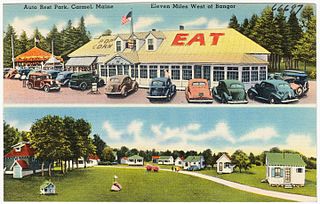
<span class="mw-page-title-main">Hope, Maine</span> Town in Maine, United States

Hope is a town in Knox County, Maine, United States. The population was 1,698 at the 2020 census.

<span class="mw-page-title-main">Nobleboro, Maine</span> Town in Maine, United States

Nobleboro, founded in 1788, is a town in Lincoln County, Maine, United States. The population was 1,791 at the 2020 census. Nobleboro is named for Arthur Noble's son Arthur II. Part of Nobleboro was part of Shem Drowne's claim in the 1730s.

<span class="mw-page-title-main">Smithfield, Maine</span> Town in the state of Maine, United States

Smithfield is a town in Somerset County, Maine, United States. The population was 925 at the 2020 census. The town was incorporated on February 29, 1840, making it the only town in Maine incorporated on Leap Day. The town was named after the Rev. Henry Smith, an early settler.

<span class="mw-page-title-main">Whitneyville, Maine</span> Town in the state of Maine, United States

Whitneyville is a town in Washington County, Maine, United States. The town was named after Colonel Joseph Whitney, a mill owner. The population was 202 at the 2020 census.

<span class="mw-page-title-main">Windham, Vermont</span> Town in Vermont, United States

Windham is a town in Windham County, Vermont, United States. The population was 449 at the 2020 census. The town center village is designated as the Windham Village Historic District.

<span class="mw-page-title-main">Ivor, Virginia</span> Town in Virginia, United States

Ivor is an incorporated town in Southampton County, Virginia, United States. It is twenty-three miles northwest of Suffolk. The population was 320 at the 2000 census.

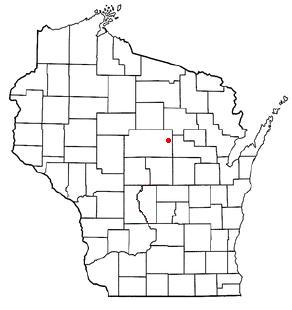
Sioux Creek is a town in Barron County in the U.S. state of Wisconsin. The population was 655 at the 2010 census.

<span class="mw-page-title-main">Modena, Wisconsin</span> Town in Wisconsin, United States

Modena is a town in Buffalo County in the U.S. state of Wisconsin. The population was 354 at the 2010 census. The unincorporated community of Urne is also located partially in the town.

<span class="mw-page-title-main">Elba, Wisconsin</span> Town in Wisconsin, United States

Elba is a town in Dodge County, Wisconsin, United States. The population was 1,086 at the 2000 census. The unincorporated communities of Astico and Danville are located in the town.

<span class="mw-page-title-main">Johnson, Wisconsin</span> Town in Wisconsin, United States

The Town of Johnson is located in Marathon County, Wisconsin, United States. It is part of the Wausau, Wisconsin Metropolitan Statistical Area. The population was 985 at the 2010 census. The unincorporated communities of Corinth, Milan, and Wuertsburg are located in the town.

<span class="mw-page-title-main">Norrie, Wisconsin</span> Town in Wisconsin, United States

The Town of Norrie is located in Marathon County, Wisconsin, United States. It is part of the Wausau, Wisconsin Metropolitan Statistical Area. The population was 976 at the 2010 census.

<span class="mw-page-title-main">Reid, Wisconsin</span> Town in Marathon County, Wisconsin, United States

The Town of Reid is located in Marathon County, Wisconsin, United States. It is part of the Wausau, WI Metropolitan Statistical Area. The population was 1,215 at the 2010 census. The unincorporated communities of Little Eau Claire and Pike Lake are located in the town. The unincorporated community of Bevent is located partially in the town.

<span class="mw-page-title-main">McKinley, Polk County, Wisconsin</span> Town in Wisconsin, United States

The Town of McKinley is located in Polk County, Wisconsin, United States. The population was 328 at the 2000 census.

<span class="mw-page-title-main">Dodge, Wisconsin</span> Town in Wisconsin, United States

Dodge is a town in Trempealeau County, Wisconsin, United States. The population was 414 at the 2000 census. The census-designated place of Dodge is located in the town. The unincorporated community of Pine Creek is also located in the town.

The Town of Weston is located in Marathon County, Wisconsin, United States. It is part of the Wausau, Wisconsin Metropolitan Statistical Area. The population was 657 at the 2020 census.

Somerset is a town in St. Croix County, Wisconsin, United States. The population was 4,036 at the 2010 census. The Village of Somerset is adjacent to the town.

<span class="mw-page-title-main">Hillsboro (town), Wisconsin</span> Town in Wisconsin, United States

Hillsboro is a town in Vernon County, Wisconsin, United States. The population was 766 at the 2000 census. The City of Hillsboro is located within the town. The unincorporated community of Trippville is also located in the town.

References

  1. 1 2 "US Board on Geographic Names". United States Geological Survey. October 25, 2007. Retrieved January 31, 2008.
  2. 1 2 "U.S. Census website". United States Census Bureau . Retrieved January 31, 2008.