
Wangaratta is a city in the northeast of Victoria, Australia, 236 km (147 mi) from Melbourne along the Hume Highway. The city had a population of 29,808 per the 2021 Australian Census.

Endeavour Hills is a suburb in Melbourne, Victoria, Australia, 31 km (19 mi) south-east of Melbourne's Central Business District, located within the City of Casey local government area. Endeavour Hills recorded a population of 24,455 at the 2021 census.

Clyde North is a suburb in Melbourne, Victoria, Australia, 46 km south-east of Melbourne's Central Business District, located within the City of Casey local government area. Clyde North recorded a population of 31,681 at the 2021 census.

Cranbourne is a suburb in Melbourne, Victoria, Australia, 43 km south-east of Melbourne's Central Business District, located within the City of Casey local government area. Cranbourne recorded a population of 21,281 at the 2021 census.
Cranbourne North is a suburb in Melbourne, Victoria, Australia, 39 km south-east of Melbourne's Central Business District, located within the City of Casey local government area. Cranbourne North recorded a population of 24,683 at the 2021 census.

Lynbrook is a suburb in Melbourne, Victoria, Australia, 36 km south-east of Melbourne's Central Business District, located within the City of Casey local government area. Lynbrook recorded a population of 9,121 at the 2021 census.

Pearcedale is a township and coastal rural locality in Victoria, Australia, 49 km south-east of Melbourne's Central Business District, located within the City of Casey and the Shire of Mornington Peninsula local government areas. Pearcedale recorded a population of 3,867 at the 2021 census.

Noble Park is a suburb in Melbourne, Victoria, Australia, 25 km south-east of Melbourne's Central Business District, located within the City of Greater Dandenong local government area. Noble Park recorded a population of 32,257 at the 2021 census.
Langwarrin is a suburb in Melbourne, Victoria, Australia, 42 km (26 mi) south-east of Melbourne's Central Business District, located within the City of Frankston local government area. Langwarrin recorded a population of 23,588 at the 2021 census.
Skye is a suburb and semi-rural locality in Melbourne, Victoria, Australia, 48 km south-east of Melbourne's Central Business District via the Monash Freeway, located within the City of Frankston local government area. Skye recorded a population of 8,088 at the 2021 census.

Campbellfield is a suburb in Melbourne, Victoria, Australia, 13 km (8.1 mi) north of Melbourne's Central Business District, located within the City of Hume local government area. Campbellfield recorded a population of 4,977 at the 2021 census.
Kealba is a suburb in Melbourne, Victoria, Australia, 15 km (9.3 mi) north-west of Melbourne's Central Business District, located within the City of Brimbank local government area. Kealba recorded a population of 3,226 the 2021 census.

Mentone is a suburb in Melbourne, Victoria, Australia, 21 km south-east of Melbourne's Central Business District, located within the City of Kingston local government area. Mentone recorded a population of 13,197 at the 2021 census.
Dandenong railway station is a commuter, regional railway station and the junction point of the Pakenham and Cranbourne lines, which are both part of the Melbourne railway network. It serves the south-eastern suburb of Dandenong, in Melbourne, Victoria, Australia. Dandenong station is a ground level premium station, featuring three platforms, an island platform with two faces and one side platform. It opened on 8 October 1877, with the current station provided in 1995.

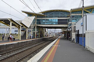
Hallam railway station is a commuter railway station on the Pakenham line, which is part of the Melbourne railway network. It serves the south-eastern suburb of Hallam, in Melbourne, Victoria, Australia. Hallam station is an elevated premium station, featuring two side platforms. It opened on 1 December 1880, with the current station provided in 2022.

Cranbourne railway station is a commuter railway station and the terminus of the Cranbourne line, which is part of the Melbourne railway network. It serves the south-eastern suburb of Cranbourne, in Melbourne, Victoria, Australia. Cranbourne station is a ground level unstaffed station, featuring an island platform with two faces. It opened on 1 October 1888, with the current station provided in 2008. It initially closed on 24 July 1993, then reopened on 24 March 1995.

Lynbrook railway station is a commuter railway station on the Cranbourne line, which is part of the Melbourne railway network. It serves the south-eastern suburb of Lynbrook, in Melbourne, Victoria, Australia. Lynbrook station is a ground level premium station, featuring two side platforms. It opened on 22 April 2012.
Western Port Highway is a highway in Victoria, Australia, linking the south-eastern fringe of suburban Melbourne to the port of Hastings nearly 30km to the south on the western coast of Western Port, after which the highway is named.
Narre Warren is a suburb in Melbourne, Victoria, Australia, 38 km southeast of Melbourne's Central Business District, located within the City of Casey local government area. Narre Warren recorded a population of 27,689 at the 2021 census.
Hallam Road is a major urban arterial road in the south-eastern suburbs of Melbourne, Victoria, Australia. Within Hampton Park the road is known as Hallam Road, whilst on its northern sections the allocation is still best known as by the names of its constituent parts: Hallam North Road, Belgrave–Hallam Road, and Hallam South Road. This article will deal with the entire length of the corridor for sake of completion, as well to avoid confusion between declarations.


