Dąbrówka is a village in the administrative district of Gmina Kowal, within Włocławek County, Kuyavian-Pomeranian Voivodeship, in north-central Poland.

Çərtəyəz is a village and municipality in the Kurdamir Rayon of Azerbaijan.
Sahiloba is a village in the Neftchala Rayon of Azerbaijan. The village forms part of the municipality of Mikayıllı.
Qızqayıtdı is a village in the Neftchala Rayon of Azerbaijan. The village forms part of the municipality of Mikayıllı. According to Azerbaijan's State Statistics Committee, only three people lived in the village as of 2014.
Rük is a village in the Quba Rayon of Azerbaijan. The village forms part of the municipality of Söhüb.
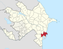
Göyyal is a village in the Qubadli Rayon of Azerbaijan. Göyyal is the Azeri village in Qubadli
Adamów is a village in the administrative district of Gmina Żarnów, within Opoczno County, Łódź Voivodeship, in central Poland.

Kęszyce-Wieś is a village in the administrative district of Gmina Bolimów, within Skierniewice County, Łódź Voivodeship, in central Poland. It lies approximately 8 kilometres (5 mi) north of Bolimów, 21 km (13 mi) north of Skierniewice, and 62 km (39 mi) north-east of the regional capital Łódź.
Nowe Kęszyce is a village in the administrative district of Gmina Bolimów, within Skierniewice County, Łódź Voivodeship, in central Poland. It lies approximately 8 kilometres (5 mi) north of Bolimów, 22 km (14 mi) north of Skierniewice, and 62 km (39 mi) north-east of the regional capital Łódź.

Falsztyn is a village in the administrative district of Gmina Łapsze Niżne, within Nowy Targ County, Lesser Poland Voivodeship, in southern Poland, close to the border with Slovakia. It lies approximately 4 kilometres (2 mi) north-east of Łapsze Niżne, 20 km (12 mi) east of Nowy Targ, and 75 km (47 mi) south of the regional capital Kraków.
Jaroszówka is a village in the administrative district of Gmina Gdów, within Wieliczka County, Lesser Poland Voivodeship, in southern Poland.

Skorodne is a village in the administrative district of Gmina Lutowiska, within Bieszczady County, Subcarpathian Voivodeship, in south-eastern Poland, close to the border with Ukraine. It lies approximately 6 kilometres (4 mi) north-west of Lutowiska, 18 km (11 mi) south of Ustrzyki Dolne, and 96 km (60 mi) south-east of the regional capital Rzeszów.
Jasieniec is a village in the administrative district of Gmina Głowaczów, within Kozienice County, Masovian Voivodeship, in east-central Poland.
Daniszewo is a village in the administrative district of Gmina Bulkowo, within Płock County, Masovian Voivodeship, in east-central Poland. It lies approximately 31 kilometres (19 mi) east of Płock and 71 km (44 mi) north-west of Warsaw.
Kotal is a village in the municipality of Ələt in the Qaradağ raion of Baku, Azerbaijan.
Mollalar is a village in the Agdam Rayon of Azerbaijan.
Cząstkowo is a village in the administrative district of Gmina Trąbki Wielkie, within Gdańsk County, Pomeranian Voivodeship, in northern Poland. It lies approximately 7 kilometres (4 mi) west of Trąbki Wielkie, 19 km (12 mi) south-west of Pruszcz Gdański, and 28 km (17 mi) south-west of the regional capital Gdańsk.
Częstkowo is a village in the administrative district of Gmina Szemud, within Wejherowo County, Pomeranian Voivodeship, in northern Poland. It lies approximately 6 kilometres (4 mi) west of Szemud, 13 km (8 mi) south-west of Wejherowo, and 35 km (22 mi) north-west of the regional capital Gdańsk.
Zacisze is a village in the administrative district of Gmina Węgorzewo, within Węgorzewo County, Warmian-Masurian Voivodeship, in northern Poland, close to the border with the Kaliningrad Oblast of Russia. It lies approximately 14 kilometres (9 mi) south-west of Węgorzewo and 82 km (51 mi) north-east of the regional capital Olsztyn.
Geniai (Varėna) is a village in Varėna district municipality, in Alytus County, in southeastern Lithuania. According to the 2001 census, the village has a population of 43 people.