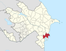
Coordinates: 39°19′N48°48′E / 39.317°N 48.800°E
A geographic coordinate system is a coordinate system that enables every location on Earth to be specified by a set of numbers, letters or symbols. The coordinates are often chosen such that one of the numbers represents a vertical position and two or three of the numbers represent a horizontal position; alternatively, a geographic position may be expressed in a combined three-dimensional Cartesian vector. A common choice of coordinates is latitude, longitude and elevation. To specify a location on a plane requires a map projection.
Mürsəqulu | |
---|---|
Coordinates: 39°19′N48°48′E / 39.317°N 48.800°E | |
Country | |
Rayon | Neftchala |
Municipality | Xol Qaraqaşlı |
Time zone | AZT (UTC+4) |
• Summer (DST) | AZT (UTC+5) |
Mürsəqulu (also, Myursagulu and Mursa-Kuli) is a village in the Neftchala Rayon of Azerbaijan. The village forms part of the municipality of Xol Qaraqaşlı. [1]
Azerbaijan, officially the Republic of Azerbaijan, is a country in the South Caucasus region of Eurasia at the crossroads of Eastern Europe and Western Asia. It is bounded by the Caspian Sea to the east, Russia to the north, Georgia to the northwest, Armenia to the west and Iran to the south. The exclave of Nakhchivan is bounded by Armenia to the north and east, Iran to the south and west, and has an 11 km long border with Turkey in the northwest.
Xol Qaraqaşlı is a village and municipality in the Neftchala Rayon of Azerbaijan. It has a population of 2,839. The municipality consists of the villages of Xol Qaraqaşlı and Mürsəqulu.
Məzrə is a village in the Jabrayil Rayon of Azerbaijan.
Bozayran is a village in the Jalilabad Rayon of Azerbaijan.
Borbor is a village in the Davachi Rayon of Azerbaijan. The village forms part of the municipality of Padar.
Dahar is a village in the Ismailli Rayon of Azerbaijan. The village forms part of the municipality of Cülyan. According to Azerbaijan's State Statistics Committee, only five people lived in the village as of 2014.
Kabagtepe is a village in the Lachin Rayon of Azerbaijan.
Bagyrtugay is a village in the Sabirabad Rayon of Azerbaijan.
Məlikli is a village in the Yardymli Rayon of Azerbaijan. The village forms part of the municipality of Tahirli.
Genanly is a village in the Zangilan Rayon of Azerbaijan.
Kagramanly is a village in the Beylagan Rayon of Azerbaijan.
Peygambar is a village in the Beylagan Rayon of Azerbaijan.
Korlar is a village in the Jalilabad Rayon of Azerbaijan.
Zaryar is a village in the Jalilabad Rayon of Azerbaijan.
Babagil is a village in the Lerik Rayon of Azerbaijan. The village forms part of the municipality of Günəşli. The village contains an 18th-century tomb that is registered with the Ministry of Culture and Tourism.
Gadzhi-Eynali is a village in the Masally Rayon of Azerbaijan.
Qırmızı Şəfəq is a village in the municipality of Yenikənd in the Neftchala Rayon of Azerbaijan.
Soruşçay is a village in the municipality of Nüravud in the Lerik Rayon of Azerbaijan.
Fərəcullalı is a village and municipality in the Jalilabad Rayon of Azerbaijan. It has a population of 155.
Mirzənağılı is a village in the municipality of Qazaxlar in the Fizuli Rayon of Azerbaijan.
Orta Əlinəzərli is a village and municipality in the Beylagan Rayon of Azerbaijan. It has a population of 1,060.
İkinci Varlı is a village and municipality in the Salyan Rayon of Azerbaijan. It has a population of 822.
This Neftchala Rayon location article is a stub. You can help Wikipedia by expanding it. |