
Ziebach County is a county in the U.S. state of South Dakota. As of the 2020 census, the population was 2,413. Its county seat is Dupree. It is the last county in the United States alphabetically.

Benson County is a county in the U.S. state of North Dakota. As of the 2020 census, the population was 5,964. Its county seat is Minnewaukan. The county was created on March 9, 1883 by the Dakota Territory legislature, and was named for Bertil W. Benson, a Dakota Territory legislator at the time. The county government was organized on June 4, 1884, and its boundary lines were altered by two legislative actions in 1885.

Mellen Township is a civil township of Menominee County in the U.S. state of Michigan. The population was 1,260 at the 2000 census. It is named after pioneer settler Mellen Smith (1829–1905), who served as the first postmaster at Wallace.

Winchester is an unincorporated town and census-designated place (CDP) in Clark County, Nevada, United States that contains part of the Las Vegas Strip. It is one of a number of CDPs in the unincorporated urbanized area directly south of Las Vegas. The population was 36,403 at the 2020 census. It is governed by the Clark County Commission with advice from the Winchester Town Advisory Board. "Winchester, NV" does not appear in postal addresses; the United States Postal Service has assigned "Las Vegas, NV" as the place name for the ZIP codes containing Winchester.

Bridgeport is a census-designated place (CDP) and unincorporated community that is part of Logan Township, in Gloucester County, in the U.S. state of New Jersey. At the 2020 United States census, the population of the CDP was 389. in the 2010 census, the population was 504.

Renner is an unincorporated community in Minnehaha County in the U.S. state of South Dakota. Renner has been assigned the ZIP code of 57055. The demographics of Renner are not listed separately by the United States Census Bureau, but are included within those of Mapleton Township. The 2000 Census reported a total population of 2,128 for all of Mapleton Township.
Vale is an unincorporated community and census-designated place in Butte County, South Dakota, United States. According to the 2020 census, the population was 130. Vale has been assigned the ZIP code of 57788. The public school located in Vale, whose mascot was The Beet Diggers, closed in 1982.

Agency Village is an unincorporated area and census-designated place (CDP) in Roberts County, South Dakota, United States. It is the headquarters of the Sisseton Wahpeton Oyate and home to Sisseton Wahpeton College. Since 2020, the CDP includes the community known as Goodwill. The population of the CDP was 776 at the 2020 census.
Oak Ridge is an unincorporated community and census-designated place (CDP) located along the border of West Milford Township in Passaic County and Jefferson Township in Morris County, in the U.S. state of New Jersey. The area is served as United States Postal Service ZIP Code 07438.

Temvik is a ghost town in Emmons County, North Dakota, United States. It is situated between Linton and Hazelton. The town had a school and several grain elevators early in the twentieth century; all that remains today is a farm.

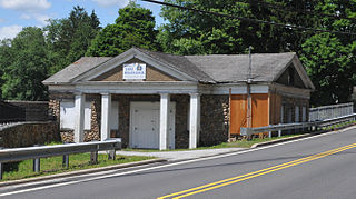
Clairfield is an unincorporated community in Claiborne County, Tennessee, United States. It is located in the upper Clearfork Valley in the Cumberland Mountains of northeastern Tennessee. It is the site of a post office, assigned ZIP code 37715. The population of the Zip Code Tabulation Area corresponding to Clairfield's ZIP code was 1,002 as of the 2000 Census.
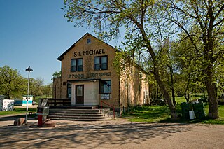
Saint Michael is an unincorporated community in southeastern Benson County, North Dakota, United States, on the Spirit Lake Dakota Reservation. It lies along North Dakota Highway 57 in Mission Township, southeast of the city of Minnewaukan, the county seat. It has a post office with the ZIP code 58370.

Jessie is a census-designated place in northern Griggs County, North Dakota, United States. An unincorporated community, it was designated as part of the U.S. Census Bureau's Participant Statistical Areas Program on March 31, 2010. It was not counted separately during the 2000 Census, but was included in the 2010 Census, where a population of 25 was reported.
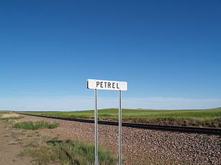
Petrel is a ghost town in Adams County, North Dakota, United States. It is located just across the border with South Dakota, between Lemmon, South Dakota, in Perkins County and Haynes. Petrel is a former railroad townsite and siding on the Milwaukee Road. The town was named for the long-winged pigeons seen in the area.
Butte Valley Township is a civil township in Benson County, North Dakota, United States. As of the 2000 census, its population was 87.
Roth is an unincorporated rural hamlet in Bottineau County in the U.S. state of North Dakota. It is located roughly 6 miles (9.7 km) to the west of Souris. There are less than half a dozen houses at Roth along a loop road, and no businesses or services.

Carbury is an unincorporated community in Bottineau County in the U.S. state of North Dakota. It is located along North Dakota Highway 14 in the eastern part of the county, east of Souris. The town is virtually abandoned, and the 2000 Census did not record a population. The post office closed in 1984, and it is now part of zip code 58783 covered by the post office in Souris.
Dryden is a small unincorporated community in Chelan County, Washington, United States. It is situated along the Wenatchee River in the fertile Wenatchee Valley between the towns of Cashmere and Leavenworth. The community serves as a supply and shipping point for local farms and orchards.
Maple Valley Township is a civil township of Montcalm County in the U.S. state of Michigan. The population was 2,083 at the 2000 census.
Elmwood Township was a township in Golden Valley County, North Dakota, United States. The former township became the Elmwood Unorganized Territory.


