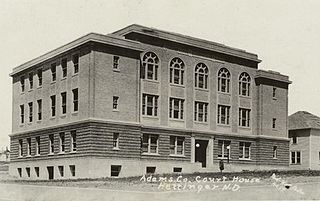
Adams County is a county in the U.S. state of North Dakota. As of the 2020 census, the population was 2,200. The county seat is Hettinger. The county was created on April 17, 1907, and organized one week later. It was named for John Quincy Adams (1848–1919), a railroad official for the Milwaukee Road Railroad and distant relative of sixth U.S. President John Quincy Adams (1767–1848).

Bismarck is the capital of the U.S. state of North Dakota and the county seat of Burleigh County. It is the state's second-most populous city, after Fargo. The city's population was 73,622 in the 2020 census, while its metropolitan population was 133,626. In 2020, Forbes magazine ranked Bismarck as the seventh fastest-growing small city in the United States.

Interstate 29 (I-29) is an Interstate Highway in the Midwestern United States. I-29 runs from Kansas City, Missouri, at a junction with I-35 and I-70, to the Canada–US border near Pembina, North Dakota, where it connects with Manitoba Provincial Trunk Highway 75 (PTH 75), which continues on to Winnipeg. The road follows the course of three major rivers, all of which form the borders of US states. The southern portion of I-29 closely parallels the Missouri River from Kansas City northward to Sioux City, Iowa, where it crosses and then parallels the Big Sioux River. For the northern third of the highway, it closely follows the Red River of the North. The major cities that I-29 connects to includes Council Bluffs, Iowa; Sioux Falls, South Dakota; Fargo, North Dakota; and Grand Forks, North Dakota.

Benson County is a county in the U.S. state of North Dakota. As of the 2020 census, the population was 5,964. Its county seat is Minnewaukan. The county was created on March 9, 1883 by the Dakota Territory legislature, and was named for Bertil W. Benson, a Dakota Territory legislator at the time. The county government was organized on June 4, 1884, and its boundary lines were altered by two legislative actions in 1885.

Polk County is a county in the northwestern part of the U.S. state of Minnesota. Its population was 31,192 at the 2020 census. Its county seat is Crookston, and the largest community is East Grand Forks.

Jamestown is a city in Stutsman County, North Dakota, United States. It is the county seat of Stutsman County. The population was 15,849 at the 2020 census, making it the ninth most populous city in North Dakota. Jamestown was founded in 1883 and is home to the University of Jamestown.

Tilden Township is a township in Berks County, Pennsylvania, United States. The population was 3,597 at the 2010 census.

Yankton is a city in and the county seat of Yankton County, South Dakota, United States.

The Town of Tilden is located in Chippewa County in the U.S. state of Wisconsin. The population was 1,485 at the 2010 census, up from 1,185 at the 2000 census.

U.S. Route 12 or U.S. Highway 12 (US 12) is an east–west United States Numbered Highway, running from Aberdeen, Washington, to Detroit, Michigan, for almost 2,500 miles (4,000 km). The highway has mostly been superseded by Interstate 90 (I-90) and I-94, but, unlike most U.S. Highways that have been superseded by an Interstate, US 12 remains as an important link for local and regional destinations. The highway's western terminus in Aberdeen is at an intersection with US 101, while the highway's eastern terminus in Downtown Detroit is at the corner of Michigan and Cass avenues, near Campus Martius Park.

Tilden is a city in Antelope and Madison counties in Nebraska, United States. The population was 953 at the 2010 census. The Madison County portion of Tilden is part of the Norfolk, Nebraska Micropolitan Statistical Area.

The North Country National Scenic Trail, generally known as the North Country Trail or simply the NCT, is a footpath stretching over 4,800 miles (7,700 km) from Middlebury in central Vermont to Lake Sakakawea State Park in central North Dakota in the United States; connecting both the Long Trail and the Appalachian Trail with the Lewis and Clark Trail. Passing through the eight states of Vermont, New York, Pennsylvania, Ohio, Michigan, Wisconsin, Minnesota and North Dakota, it is the longest of the eleven National Scenic Trails authorized by Congress. As of early 2019, 3,129 miles (5,036 km) of the trail is in place.

Charles Lee Tilden Regional Park, also known as Tilden Park or Tilden, [], is a 2,079-acre (841 ha) regional park in the East Bay, part of the San Francisco Bay Area in California. It is between the Berkeley Hills and San Pablo Ridge. Its main entrance is near Kensington, Berkeley, and Richmond. The park is contiguous with Wildcat Canyon Regional Park.

U.S. Route 81 or U.S. Highway 81 (US 81) is a major north–south U.S. highway that extends for 1,220 miles (1,960 km) in the central United States and is one of the original United States Numbered Highways established in 1926 by the American Association of State Highway Officials.

U.S. Route 281 (US 281) is a north–south United States Numbered Highway. At 1,875 miles (3,018 km) it is the longest continuous three-digit U.S. Route.

U.S. Route 83 (US 83) is a major north–south United States Numbered Highway that extends 1,885 miles (3,034 km) in the central United States. Only four other north–south routes are longer: US 1, US 41, US 59, and US 87, while US 83 follows a straighter north-south path than all of these. Nearly half of its mileage is in the state of Texas. The highway's northern terminus is north of Westhope, North Dakota, at the Canadian border, where it continues as Manitoba Highway 83 (PTH 83). The southern terminus is at the Veterans International Bridge in Brownsville, Texas. Together, US 83 and PTH 83 form a continuously numbered north-south highway with a combined distance of 3,450 kilometres (2,140 mi).

U.S. Route 183 (US 183) is a north–south United States highway. The highway's northern terminus is in Presho, South Dakota, at an intersection with Interstate 90. Its southern terminus is in Refugio, Texas, at the southern intersection of U.S. Highway 77 and Alternate US 77.

U.S. Route 85 (US 85) is a 1,479-mile-long (2,380 km) north–south United States Highway that travels in the Mountain and Northern Plains states of the United States. The southern terminus of the highway is at the Mexican border in El Paso, Texas, connecting with Mexican Federal Highway 45. The northern terminus is at the Canadian border in Fortuna, North Dakota, where the route continues north as Saskatchewan Highway 35. The highway route is part of the CanAm Highway. Sections of US 85 are designated as the Theodore Roosevelt Expressway.
The Minnesota Northern Railroad is a Class III shortline railroad that operates over 224 miles (360 km) of track in northwestern Minnesota. The railroad is co-owned by KBN Incorporated and Independent Locomotive Service and is headquartered in Crookston, Minnesota.

Iowa Highway 51 (Iowa 51) is a state highway that runs from north to south in northeast Iowa. Contained entirely by Allamakee County, it is only 11 miles (18 km) in length. It begins at U.S. Highway 18 (US 18) and US 52 in Postville and ends at Iowa 9 near Waukon.

