
Pendleton County is a county located in the U.S. state of West Virginia. As of the 2020 census, the population was 6,143, making it the second-least populous county in West Virginia. Its county seat is Franklin. The county was created by the Virginia General Assembly in 1788 from parts of Augusta, Hardy, and Rockingham counties and was named for Edmund Pendleton (1721–1803), a distinguished Virginia statesman and jurist. Pendleton County was strongly pro-Confederate during the American Civil War; however, there were pockets of Unionists who supported the state government in Wheeling.
Pendleton County is a county located in the U.S. state of Kentucky. As of the 2020 census, the population was 14,644. Its county seat is Falmouth. The county was founded December 13, 1798. Pendleton County is included in the Cincinnati-Middletown, OH-KY-IN Metropolitan Statistical Area.

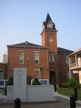
Franklin is a town in and the county seat of Pendleton County, West Virginia, United States. The population was 486 at the 2020 census. Franklin was established in 1794 and named for Francis Evick, an early settler.

The Shenandoah Valley is a geographic valley and cultural region of western Virginia and the Eastern Panhandle of West Virginia in the United States. The valley is bounded to the east by the Blue Ridge Mountains, to the west by the eastern front of the Ridge-and-Valley Appalachians, to the north by the Potomac River and to the south by the James River. The cultural region covers a larger area that includes all of the valley plus the Virginia highlands to the west, and the Roanoke Valley to the south. It is physiographically located within the Ridge and Valley province and is a portion of the Great Appalachian Valley.

Edmund Pendleton was an American planter, politician, lawyer, and judge. He served in the Virginia legislature before and during the American Revolutionary War, becoming the first speaker of the Virginia House of Delegates. Pendleton attended the First Continental Congress as one of Virginia's delegates alongside George Washington and Patrick Henry, signed the Continental Association, and led the conventions both wherein Virginia declared independence (1776) and adopted the United States Constitution (1788).

The Eastern Panhandle is the eastern of the two panhandles in the U.S. state of West Virginia; the other is the Northern Panhandle. It is a small stretch of territory in the northeast of the state, bordering Maryland and Virginia. Some sources and regional associations only identify the Eastern Panhandle as being composed of Morgan, Berkeley, and Jefferson counties. Berkeley and Jefferson counties are geographically located in the Shenandoah Valley. West Virginia is the only U.S. state with two panhandles.

The South Branch Potomac River has its headwaters in northwestern Highland County, Virginia near Hightown along the eastern edge of the Allegheny Front. After a river distance of 139 miles (224 km), the mouth of the South Branch lies east of Green Spring in Hampshire County, West Virginia where it meets the North Branch Potomac River to form the Potomac.
Rippon is an unincorporated community in Jefferson County, West Virginia, United States, located south of Charles Town and designated as a village by the Jefferson County Commission. The village of Rippon developed in the mid-19th century at the crossroads of the Berryville and Charles Town Turnpike, Withers-LaRue Road, and Myerstown Road. The town was named after nearby Ripon Lodge, although an extra "p" was added to avoid confusion with a town in Wisconsin. According to the 2000 census, the town has a population of 223.
Harper is the name of several communities in the U.S. state of West Virginia.
Oak Grove is an unincorporated community in Pendleton County, West Virginia, United States. Oak Grove lies on Smith Creek near its confluence with the South Branch Potomac River.

Blackwater Falls State Park is located in the Allegheny Mountains of Tucker County, West Virginia, US. The centerpiece of the park is Blackwater Falls, a 62-foot (19 m) cascade where the Blackwater River leaves its leisurely course in Canaan Valley and enters rugged Blackwater Canyon. It is among the most photographed venues in the state and appears on calendars, stationery, and advertisements. The river is named for its tannin-darkened water.

The West Virginia Republican Party is the affiliate of the United States Republican Party in West Virginia. Elgine McArdle is the party chair. It is currently the dominant party in the state, controlling both of West Virginia's U.S. House seats, one of the U.S. Senate seats, both houses of the state legislature, and the governorship.

The Sinks of Gandy — also called the Sinks of Gandy Creek, or simply "The Sinks" — are a modestly celebrated cave and underground stream at Osceola in eastern Randolph County, West Virginia, United States. The Sinks are on private property within the Monongahela National Forest.

Germany Valley is a scenic upland valley high in the Allegheny Mountains of eastern West Virginia originally settled by German farmers in the mid-18th century. It is today a part of the Spruce Knob–Seneca Rocks National Recreation Area of the Monongahela National Forest, although much ownership of the Valley remains in private hands.

John Overton Pendleton was a U.S. Representative from West Virginia.

U.S. Route 220 (US 220) is a U.S. Highway that travels from Rockingham, North Carolina, to South Waverly, Pennsylvania. In the state of West Virginia, it travels for 93 miles (150 km) from the Virginia state line two miles (3.2 km) south of Harper to the Maryland state line at Keyser.
Philip Clayton Pendleton was a Virginia attorney, planter, politician and jurist. He briefly served as a United States district judge of the United States District Court for the Western District of Virginia. He previously served in the Virginia House of Delegates and as a Virginia state judge.

This is a list of the National Register of Historic Places listings in Pendleton County, West Virginia.
Ugly Mountain is a summit in Pendleton County, West Virginia, in the United States. With an elevation of 2,598 feet (792 m), Ugly Mountain is the 507th highest summit in the state of West Virginia.


