Harrelson Boulevard

Last updated

Harrelson Boulevard

Dr. W. Leroy Harrelson Boulevard
Route information
Maintained by Horry County
Length1.7 mi (2.7 km)
Existed2002–present
Major junctions
Northwest endUS 17.svg US 17 in Myrtle Beach
Major intersections Grissom Parkway
Southeast endBusiness plate.svg
US 17.svg
US 17 Bus. in Myrtle Beach
Location
Country United States
State South Carolina
Counties Horry
Highway system

Harrelson Boulevard is a four-lane highway in Myrtle Beach, South Carolina, named for Myrtle Beach's first mayor Dr. W. Leroy Harrelson Sr., who was elected to office in 1938. It starts at U.S. 17, and goes to Myrtle Beach International Airport and runs near Coastal Grand Mall. The highway is also the southern terminus for Grissom Parkway. It replaced the two-lane Jetport Road.

Contents

As part of the project to expand the Myrtle Beach International Airport, Harrelson Boulevard was extended to U.S. 17 Business, with the official opening ceremony January 26, 2012. [1] [2]

The East Coast Greenway runs along Harrelson Boulevard.

Fantasy Harbour bridge

The Economic Development Industrial Cluster Act of 1996 let local governments in South Carolina use admissions tax revenues for road improvements and other infrastructure projects. Fantasy Harbour, a group of attractions off U.S. 501 west of the Intracoastal Waterway, could use such a tax to repay loans from a "state infrastructure bank" for a proposed $15 million bridge from there over the waterway to U.S. 17. [3] [4]

On August 21, 1997, Myrtle Beach City Council saw a Jetport Road master plan which called for a $10.9 million upgrade, with a new four-lane road parallel to the runway at Myrtle Beach International Airport, connecting the planned Fantasy Harbour bridge with Kings Highway at 29th Avenue South by late 1999. The new road would also intersect the planned Central Parkway. Interchanges would come later; stop lights were planned at U.S. 17, though by 2005 an interchange would be necessary there. [5] On January 26, 1999, at the request of Burroughs & Chapin, the city council voted to contribute to upgrading Jetport Road to provide access to the new mall. Other funding came from the Airport Trust Fund. [6] [7] As of December 1999, the plan was for bids on the $6 million replacement for Jetport Road by March 2000, with completion in summer 2001. [8]

In February 2001, Horry County officials voted to ask the State Infrastructure Bank for $173 million for South Carolina Highway 31, a connector from the parkway to North Myrtle Beach, and a bridge over the Intracoastal Waterway at Fantasy Harbour. The state wanted the county to match 10 percent of that amount. The portion for the Fantasy Harbour bridge was expected to come in part from the Fantasy Harbour admissions tax. The interchange at U.S. 17 and Harrelson Boulevard, which would connect to the bridge, was already being built.

The Infrastructure Bank chose not to provide money for the projects at that time, but did approve $135 million in December 2001.

On October 15, 2002, state highway officials approved $63 million for the "Main Street Connector" and the Fantasy Harbour bridge. The Fantasy Harbour bridge still had a number of obstacles, including potential environmental problems. [9] [10] [11] The interchange at U.S. Route 17 opened February 19, 2002. [12]

In July 2005, the Infrastructure Bank approved issuing $37 million in bonds for the Fantasy Harbour bridge and the North Myrtle Beach Connector. [13]

Construction began on the 1800-foot bridge in May 2007. [14]

The $46 million bridge opened July 1, 2009 more than a decade after it was first proposed. [15] This road bypasses the traffic across the waterway bridge on U.S. Route 501. It also provides a connection to Fantasy Harbour, Medieval Times, and Freestyle Music Park.[ citation needed ] Harrelson Boulevard becomes George Bishop Parkway [16] where it joins the road built years earlier.

On August 5, 2022, the bridge over US Highway 17 was named Patrolman Jacob Hancher Overpass for Myrtle Beach police officer Jacob Hancher, who was killed in the line of duty in October 2020. [17]

Extension to Kings Highway

In 1998, the Myrtle Beach City Council considered a $6 million plan to extend Harrelson Boulevard (formerly Jetport Road) to Kings Highway at 29th Avenue South as "a four-lane divided parkway with bike paths and 'gateway-style landscaping'." [18] Because of the planned mall, money for this project went to upgrading the existing road instead. [6] [7]

By September 2010, work was beginning on phase one of the road's extension, an alternative to Farrow Parkway during the reworking of that road's intersection with U.S. 17. [19]

Phase two of the road's extension to Kings Highway started September 15, 2011. [20] The extension cost $8.9 million to build. A ceremony to celebrate the road's completion took place January 26, 2012, attended by Leroy Harrelson Jr., son of the city's first mayor for whom the road is named. [2]

Major intersections

The entire route is in Horry County.

LocationmikmDestinationsNotes
Myrtle Beach 0.00.0US 17.svg US 17  Georgetown, Surfside Beach, North Myrtle Beach Western terminus
0.290.47 Grissom Parkway Southwestern terminus of Grissom Parkway
0.340.55Hwy 15
1.11.8Jetport Road (Myrtle Beach Intl. Airport)
1.72.7Business plate.svg
US 17.svg
US 17 Bus.  Myrtle Beach, Surfside Beach
Eastern terminus
1.000 mi = 1.609 km; 1.000 km = 0.621 mi

Related Research Articles

<span class="mw-page-title-main">Myrtle Beach, South Carolina</span> City in South Carolina, United States

Myrtle Beach is a resort city on the east coast of the United States in Horry County, South Carolina. It is located in the center of a long and continuous 60-mile (97 km) stretch of beach known as the "Grand Strand” in the northeastern part of the state. Its year-round population was 35,682 as of the 2020 census, making it the 13th-most populous city in South Carolina.

<span class="mw-page-title-main">Myrtle Beach International Airport</span> Airport

Myrtle Beach International Airport is a county-owned public-use airport located three nautical miles (6 km) southwest of the central business district of Myrtle Beach, in Horry County, South Carolina, United States. It was formerly known as Myrtle Beach Jetport (1974–1989) and is located on site of the former Myrtle Beach Air Force Base, which also includes The Market Common shopping complex.

<span class="mw-page-title-main">Florida State Road 528</span> Highway in Florida

State Road 528 (SR 528), alternatively named the Martin Andersen Beachline Expressway, is a partially-tolled state road in the U.S. state of Florida; it is maintained by the Florida's Turnpike Enterprise (FTE), the Central Florida Expressway Authority (CFX), and the Florida Department of Transportation (FDOT). Spanning approximately 53 miles (85 km) along a west–east axis, it connects Interstate 4 (I-4) in Orlando with I-95, Titusville, and Cape Canaveral on the Space Coast. It passes close to the tourist areas of Orlando, including SeaWorld and Universal Orlando, and serves the north entrance to Orlando International Airport. Near its east end, it passes over the Intracoastal Waterway on the Emory L. Bennett Causeway, and ends at SR A1A and SR 401 near Port Canaveral.

<span class="mw-page-title-main">U.S. Route 378</span> U.S. Highway in Georgia and South Carolina

U.S. Route 378 (US 378) is a spur of US 78 in the U.S. states of Georgia and South Carolina. The U.S. Highway runs 234.30 miles (377.07 km) from US 78, Georgia State Route 10 (SR 10), SR 17, and SR 47 in Washington, Georgia, east to US 501 Business in Conway, South Carolina. US 378 connects the Central Savannah River Area in both states with the Midlands and Pee Dee regions of South Carolina. The U.S. Highway's western portion, which connects Washington and Lincolnton in Georgia and McCormick, Saluda, and Lexington in South Carolina, is mainly a rural highway. US 378 is a major suburban and urban highway through Lexington and South Carolina's state capital, Columbia. The highway has a lengthy concurrency with US 76 between Columbia and Sumter and serves as a major route between the Midlands and the Myrtle Beach area, between which the highway has a business route through Lake City.

<span class="mw-page-title-main">Grand Strand</span> Coastal area in South Carolina, US

The Grand Strand is an arc of beach land on the Atlantic Ocean in South Carolina, United States, extending more than 60 miles (97 km) from Little River to Winyah Bay. It is located in Horry and Georgetown Counties on the NE South Carolina coast.

<span class="mw-page-title-main">Carolina Forest, South Carolina</span> Census-designated place in South Carolina, United States

Carolina Forest is a census-designated place (CDP) in Horry County, South Carolina, United States. It was first listed as a CDP in the 2020 census with a population of 23,342.

<span class="mw-page-title-main">South Carolina Highway 31</span> State highway in South Carolina

South Carolina Highway 31 (SC 31), also known as the Carolina Bays Parkway, is a 28.097-mile (45.218 km) six-lane, limited-access highway that parallels the Intracoastal Waterway around Myrtle Beach. The first phase opened on December 17, 2002, completing a 22-mile (35 km) link between U.S. Route 501 (US 501) and SC 9. The second phase opened in March 2005, running from US 501 southwest to S.C. Highway 544. The third phase opened on November 7, 2019, extending to SC 707. While usually referred to only as the Carolina Bays Parkway, the highway is also dedicated the John B. Singleton Parkway in memory of John B. Singleton, a former Myrtle Beach City Council member and police commissioner.

Waccamaw Corp. was a home furnishings business that started in 1977 as Waccamaw Pottery, a Myrtle Beach, South Carolina based pottery company founded by George Bishop that sold pottery and crafts.

<span class="mw-page-title-main">Farrow Parkway</span> Parkway in South Carolina, U.S.

Farrow Parkway is a four-lane, 3.5-mile (5.6 km) parkway that connects US 17 and US 17 Business in Myrtle Beach, South Carolina. The $6.9 million roadway replaced a former two-lane roadway through the former Myrtle Beach Air Force Base with funding from the city of Myrtle Beach funds and Horry County RIDE funds. Farrow Parkway is named after William G. Farrow who was a member of the Doolittle’s Raiders in World War II.

Robert Edge Parkway is a connection highway in North Myrtle Beach, South Carolina. It begins at U.S. Route 17 (US 17) and Main Street, crosses the Intracoastal Waterway, has an interchange with South Carolina Highway 31 (SC 31) or the Carolina Bays Parkway, and terminates at an intersection with SC 90. The project consisted of upgrading Firetower Road, adding a new interchange for SC 31, expanding Main Street in North Myrtle Beach to accommodate the increase in traffic, and a 1,000-foot bridge (300 m) over the Intracoastal Waterway which includes a 10-foot-wide path (3.0 m) for walkers and bicycles. Formerly known as the Main Street Connector, the road has been named for Robert Edge Sr., the first mayor of North Myrtle Beach starting in 1968. For twelve years before that, Edge was the mayor of Crescent Beach, one of the four towns which, through Edge's efforts, became North Myrtle Beach. The road opened September 3, 2009.

<span class="mw-page-title-main">South Carolina Highway 707</span>

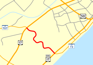
South Carolina Highway 707 (SC 707) is a 12.645-mile (20.350 km) state highway in Georgetown and Horry counties, in the northeastern part of the U.S. state of South Carolina, in the Myrtle Beach metropolitan area. It begins at U.S. Highway 17 Business in Murrells Inlet to US 17 across from Farrow Parkway near Socastee, South Carolina.

<span class="mw-page-title-main">South Carolina Highway 22</span> State highway in South Carolina

South Carolina Highway 22 (SC 22), also known as the Conway Bypass and Veterans Highway, is a four lane freeway that connects US 501 north of Conway, South Carolina, to US 17 in Myrtle Beach. The road was opened to traffic on May 4, 2001, six months ahead of schedule. There is speculation that it could become part of Interstate 73 in the future. The road largely meets Interstate Highway standards, but in order to support increased Interstate traffic, its shoulders would need to be expanded to standard width.

<span class="mw-page-title-main">South Carolina Highway 544</span> State highway in South Carolina

South Carolina Highway 544 (SC 544) is a 13.710-mile (22.064 km) major four-lane state highway in Horry County, South Carolina. It connects the Surfside Beach and Conway areas. The highway is sometimes known as Dick Pond Road in the Socastee area.

<span class="mw-page-title-main">Robert Grissom Parkway</span>

Robert M. Grissom Parkway, locally known as Grissom Parkway, is a major four-lane connector highway in Myrtle Beach, South Carolina. The road begins at Harrelson Boulevard near Myrtle Beach International Airport and terminates in Carolina Forest, South Carolina at SC Highway 31 and International Drive. It provides access to Myrtle Beach attractions such as Coastal Grand Mall, TicketReturn.com Field and Broadway at the Beach and is used as an alternative road to U.S. 17 and Kings Highway in Myrtle Beach. It has bike paths and sidewalks for pedestrian traffic. These are part of the East Coast Greenway, a 3,000 mile long system of trails connecting Maine to Florida.

The Southern Evacuation Lifeline (SELL) is a proposed 28-mile (45 km) limited-access highway in Horry County, South Carolina, in the United States. The project is currently underfunded, expecting to cost around $600 million, and issues with the route itself still remain, as it would travel directly next to several wildlife preserves.

<span class="mw-page-title-main">Interstate 73 in South Carolina</span> Highway in South Carolina

Interstate 73 (I-73) is the designation for a future Interstate Highway in the US state of South Carolina. When completed, it will connect the Grand Strand area with the state's Interstate system.

Road Improvement and Development Effort or RIDE is a plan for road projects in Horry County, South Carolina, including Carolina Bays Parkway, Veterans Highway and Robert Grissom Parkway. The first phase, costing $1.1 billion, was being paid for by hospitality taxes. The second phase, called RIDE II, was being paid for through a one-cent sales tax approved by Horry County voters November 7, 2006. RIDE III was being planned as of 2013 and voters approved a penny tax in 2016.

Mr. Joe White Avenue is a boulevard in Myrtle Beach, South Carolina, named for "Mr. Joe", a shoeshine man in Georgetown County, South Carolina, and later Myrtle Beach. Along with U.S. Route 501, Farrow Parkway, Harrelson Boulevard and 21st Avenue North, the upgraded road is one of five major entrances into Myrtle Beach.

Lewis Ocean Bay Heritage Preserve is a 10,427-acre natural preserve near Carolina Forest, South Carolina.

Myrtle Beach Air Force Base was a United States Air Force base located near Myrtle Beach, South Carolina.

References

  1. Bryant, Dawn; Saldinger, Adva; Spring, Jake (2011-01-02). "Top business stories to watch in 2011 in Myrtle Beach area". The Sun News . Archived from the original on 2013-01-05. Retrieved 2011-01-02.
  2. 1 2 Dickerson, Brad (2012-01-26). "Extension of Harrelson Boulevard officially open". The Sun News . Archived from the original on 2012-01-29. Retrieved 2012-01-26.
  3. "Legislative Update January 16, 1996, Vol. 13, No. 1". South Carolina Legislature Online. Archived from the original on August 21, 2009. Retrieved 2009-07-09.
  4. Scheinberg, Phyllis F. (1997-03-06). "Prospects for Innovation Through Research, Intelligent Transportation Systems, State Infrastructure Banks, and Design-Build Contracting" . Retrieved 2009-07-09.
  5. Katie Merx, "Planners See Jetport Road As Future Traffic Solution," The Sun News, August 22, 1997, p. 1A.
  6. 1 2 John C. Stevenson, "B&C Asks MB to Shift Jetport Road Work," The Sun News, January 22, 1999, p. A1.
  7. 1 2 Charbonee La Belle, "MB Grants B&C Request for Shift," The Sun News, January 27, 1999, p. C4.
  8. Stan Choe, "City Must Decide on Funding of Road," The Sun News, December 10, 1999, p. C3.
  9. Steve Jones, "Horry County, S.C., Attempts to Secure Loan to Extend Bay Parkway," The Sun News, February 22, 2001.
  10. Natalie Burrowes Pruitt, "NMB Planning for Road Money," The Sun News, February 26, 2002.
  11. Kevin Wiatrowski, "DOT Approves $63 Million for RIDE Projects," The Sun News, October 16, 2002, p. A1.
  12. Kevin Wiatrowski, "Interchange a Fantasy No More," The Sun News, February 20, 2002, p. A1.
  13. Zane Wilson, "Road-fund Request Faces Others'," The Sun News, October 20, 2005.
  14. Monique Newton, "Fantasy Harbour Project on Track", The Sun News, July 13, 2007, p. A1.
  15. Dawsey, Josh (July 2, 2009). "Fantasy Harbour Bridge Opens for Travel in Myrtle Beach Area". The Sun News . Archived from the original on August 16, 2013. Retrieved July 7, 2009.
  16. Prabhu, Maya (April 25, 2015). "Hundreds of officers, thousands of barricades and large crowds to fill the streets Memorial Day weekend". The Sun News. Retrieved April 25, 2015.
  17. Benson, Adam (August 5, 2022). "Fallen Myrtle Beach officer recalled as mentor, guardian at bridge dedication". The Sun News.
  18. Katie Merx, "$6 Million Plan Would Make Airport More Easily Accessible", The Sun News, June 8, 1998, p. A1.
  19. Claudia Lauer, "Harrelson Boulevard work kicks up in Myrtle Beach; Back gate alternative under way," The Sun News, September 4, 2010, Section A.
  20. Dickerson, Brad (2011-09-15). "Myrtle Beach Airport planning common-use system". The Sun News . Retrieved 2011-09-15.[ permanent dead link ]

33°41′43″N78°55′39″W / 33.6953154°N 78.927612°W / 33.6953154; -78.927612