Hazel Dell North, Washington

Last updated

Hazel Dell North, Washington
Former CDP
Clark County Washington Incorporated and Unincorporated areas Hazel Dell North Highlighted.svg
Location of Hazel Dell North, Washington
Coordinates: 45°41′14″N122°39′29″W / 45.68722°N 122.65806°W / 45.68722; -122.65806 [1]
CountryUnited States
State Washington
County Clark
Area
  Total2.7 sq mi (6.9 km2)
  Land2.7 sq mi (6.9 km2)
  Water0.0 sq mi (0.0 km2)
Population
 (2000)
  Total9,261
  Density3,469.3/sq mi (1,339.5/km2)
Time zone UTC-8 (Pacific (PST))
  Summer (DST) UTC-7 (PDT)
FIPS code 53-30312 [2]

Hazel Dell North was the name of a census-designated place in Clark County, Washington, United States. The population was 9,261 at the 2000 census. For the 2010 census the U.S. Census Bureau combined Hazel Dell North and South to form a single CDP named "Hazel Dell".

Contents

Geography

According to the United States Census Bureau, the CDP had a total area of 2.7 square miles (6.9 km2), of which 0.37% was water.

Climate

This region typically experiences warm and dry summers, with the average monthly temperatures at 71.6 °F. According to the Köppen Climate Classification system, Hazel Dell North has a warm-summer Mediterranean climate, abbreviated "Csb" on climate maps. [3]

Climate data for Hazel Dell North, Washington
MonthJanFebMarAprMayJunJulAugSepOctNovDecYear
Mean daily maximum °F (°C)42
(6)
48
(9)
53
(12)
60
(16)
66
(19)
71
(22)
78
(26)
78
(26)
73
(23)
62
(17)
51
(11)
44
(7)
60
(16)
Daily mean °F (°C)37
(3)
41
(5)
44
(7)
50
(10)
55
(13)
60
(16)
66
(19)
66
(19)
60
(16)
51
(11)
44
(7)
39
(4)
50.0
(10.0)
Mean daily minimum °F (°C)32
(0)
33
(1)
35
(2)
39
(4)
44
(7)
50
(10)
53
(12)
51
(11)
48
(9)
42
(6)
37
(3)
33
(1)
41
(5)
Average precipitation inches (mm)5.8
(150)
4.3
(110)
3.8
(97)
2.6
(66)
2.2
(56)
1.7
(43)
0.8
(20)
0.9
(23)
1.8
(46)
3.1
(79)
5.8
(150)
6.4
(160)
39.1
(990)
Average snowfall inches (cm)0.5
(1.3)
0.6
(1.5)
0.2
(0.51)
0.0
(0.0)
0.0
(0.0)
0.0
(0.0)
0.0
(0.0)
0.0
(0.0)
0.0
(0.0)
0.0
(0.0)
0.0
(0.0)
0.2
(0.51)
1.5
(3.8)
Average precipitation days (≥ 0.01 in.)20.31619.217.414.89.74.23.97.714.220.520.3168.2
Average snowy days (≥ 0.1 in.)0.50.50.20.00.00.00.00.00.00.00.00.51.7
Source: weatherbase.com

Demographics

Historical population
CensusPop.Note
1990 6,924
2000 9,26133.8%
source: [4]

As of the census [2] of 2000, there were 9,261 people, 3,535 households, and 2,403 families residing in the CDP. The population density was 3,469.3 people per square mile (1,339.2/km2). There were 3,744 housing units at an average density of 1,402.5/sq mi (541.4/km2). The racial makeup of the CDP was 84.29% White, 2.58% African American, 0.87% Native American, 2.24% Asian, 0.41% Pacific Islander, 6.04% from other races, and 3.57% from two or more races. Hispanic or Latino of any race were 11.20% of the population. 14.6% were of German, 10.4% English, 8.1% Irish and 6.6% American ancestry according to Census 2000.

There were 3,535 households, out of which 34.9% had children under the age of 18 living with them, 51.7% were married couples living together, 11.9% had a female householder with no husband present, and 32.0% were non-families. 24.8% of all households were made up of individuals, and 8.1% had someone living alone who was 65 years of age or older. The average household size was 2.62 and the average family size was 3.11.

In the CDP, the age distribution of the population shows 27.7% under the age of 18, 9.9% from 18 to 24, 30.5% from 25 to 44, 21.1% from 45 to 64, and 10.7% who were 65 years of age or older. The median age was 34 years. For every 100 females, there were 99.0 males. For every 100 females age 18 and over, there were 95.4 males.

The median income for a household in the CDP was $43,063, and the median income for a family was $48,610. Males had a median income of $40,087 versus $29,968 for females. The per capita income for the CDP was $19,518. About 11.8% of families and 14.5% of the population were below the poverty line, including 23.4% of those under age 18 and 3.8% of those age 65 or over.

Related Research Articles

<span class="mw-page-title-main">Meridianville, Alabama</span> Census-designated place in Alabama, United States

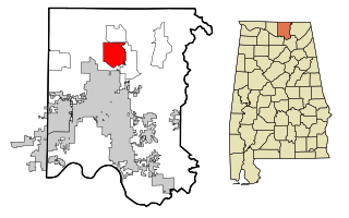
Meridianville is an unincorporated community and census-designated place (CDP) in Madison County, Alabama, United States, and is included in the Huntsville-Decatur Combined Statistical Area. As of the 2020 census, the population of the CDP was 8,209.

<span class="mw-page-title-main">Kachina Village, Arizona</span> CDP in Coconino County, Arizona

Kachina Village is a census-designated place (CDP) in Coconino County, Arizona, United States. The population was 2,622 at the 2010 census. Kachina Village is primarily a bedroom community for Flagstaff.

<span class="mw-page-title-main">Mountainaire, Arizona</span> CDP in Coconino County, Arizona

Mountainaire is a census-designated place (CDP) in Coconino County, Arizona, United States. The population was 1,119 at the 2010 census.

<span class="mw-page-title-main">East Whittier, California</span> Unincorporated community in California, United States

East Whittier is an unincorporated community in Los Angeles County, California, United States. The population was 9,757 at the 2010 census, up from 9,538 at the 2000 census. For statistical purposes, the United States Census Bureau has defined this community as a census-designated place (CDP). The name was changed from East La Mirada in 2012, likely due to its precise location in relation to the city of Whittier. The previous delineation of East Whittier CDP occurred during the 1960 census, when the area recorded a population of 19,884.

<span class="mw-page-title-main">North Auburn, California</span> Census-designated place in California, United States

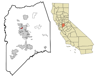
North Auburn is a census-designated place (CDP) in Placer County, California, United States. It is part of the Sacramento–Arden-Arcade–Roseville Metropolitan Statistical Area. The population was 13,452 at the 2020 census.

<span class="mw-page-title-main">Lincoln Village, California</span> Census-designated place in California, United States

Lincoln Village is a census-designated place (CDP) in San Joaquin County, California, United States. The population was 4,381 at the 2010 census, up from 4,216 at the 2000 census.

<span class="mw-page-title-main">Greenview, California</span> Census-designated place in California

Greenview is a census-designated place (CDP) in Siskiyou County, California, United States. Its population is 208 as of the 2020 census, up from 201 from the 2010 census.

<span class="mw-page-title-main">Ivanhoe, California</span> Census designated place in California, United States

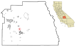
Ivanhoe is a census-designated place (CDP) in Tulare County, California, United States. The population was 4,495 at the 2010 census, up from 4,474 at the 2000 census.

<span class="mw-page-title-main">Strathmore, California</span> Census-designated place in California, United States

Strathmore is a census-designated place (CDP) in Tulare County, California, United States. The population was 2,819 at the 2010 census, up from 2,584 at the 2000 census.

<span class="mw-page-title-main">Babson Park, Florida</span> Census-designated place in Florida, US

Babson Park is a census-designated place (CDP) in Polk County, Florida, United States. The population was 1,182 at the 2000 census. It is also the home of Webber International University.

<span class="mw-page-title-main">Shark River Hills, New Jersey</span> Populated place in Monmouth County, New Jersey, US

Shark River Hills is an unincorporated community and census-designated place (CDP) within Neptune Township, in Monmouth County, in the U.S. state of New Jersey. As of the 2010 United States Census, the CDP's population was 3,697.

<span class="mw-page-title-main">Aquebogue, New York</span> Hamlet and census-designated place in New York, United States

Aquebogue is a census-designated place (CDP) roughly corresponding to the hamlet by the same name in the Town of Riverhead in Suffolk County, on Long Island, in New York, United States. The CDP's population was 2,438 at the 2010 census.

<span class="mw-page-title-main">Knippa, Texas</span> Census-designated place in Texas, United States

Knippa is a census-designated place (CDP) in Uvalde County, Texas, United States. The population was 689 at the 2010 census.

<span class="mw-page-title-main">Collinsville, Virginia</span> CDP in Virginia, United States

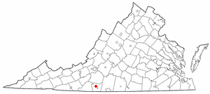
Collinsville is a census-designated place (CDP) in Henry County, Virginia, United States. The population was 7,335 at the 2010 census, which was down from the 7,777 reported in 2000. It is part of the Martinsville Micropolitan Statistical Area. Collinsville is also where the administration building and county courthouse of Henry County are located.

<span class="mw-page-title-main">Hazel Dell South, Washington</span> Former CDP in Washington, United States

Hazel Dell South was the name of a census-designated place (CDP) in Clark County, Washington, United States. The population was 6,605 at the 2000 census. For the 2010 census the U.S. Census Bureau combined this area with Hazel Dell North to form a single CDP called "Hazel Dell".

<span class="mw-page-title-main">Lake Shore, Washington</span> Census-designated place in Washington, United States

Lake Shore is a census-designated place (CDP) in Clark County, Washington, United States. The population was 6,571 at the 2010 census.

<span class="mw-page-title-main">Salmon Creek, Washington</span> Census-designated place in Washington, United States

Salmon Creek is a census-designated place (CDP) in Clark County, Washington, United States. The population was 19,686 at the 2010 census, up from 16,767 at the 2000 census.

<span class="mw-page-title-main">Walnut Grove, Washington</span> Census-designated place in Washington, United States

Walnut Grove is a census-designated place (CDP) in Clark County, Washington, United States. The population was 9,790 at the 2010 census, up from 7,164 at the 2000 census.

<span class="mw-page-title-main">Rockport, Washington</span> CDP in Washington, United States

Rockport is a census-designated place (CDP) in Skagit County, Washington, United States. The population was 109 at the 2010 census. It is included in the Mount Vernon–Anacortes, Washington Metropolitan Statistical Area.

Hollins is a census-designated place (CDP) in Botetourt and Roanoke County, Virginia, United States. Hollins covers much of the area known locally as "North County". The population was 15,574 at the 2020 census. It is part of the Roanoke Metropolitan Statistical Area. The area is also the home of Hollins University in addition to four properties listed on the National Register of Historic Places: the Black Horse Tavern-Bellvue Hotel and Office, Harshbarger House, the Hollins College Quadrangle, and Old Tombstone.

References

  1. "US Gazetteer files: 2010, 2000, and 1990". United States Census Bureau. February 12, 2011. Retrieved April 23, 2011.
  2. 1 2 "U.S. Census website". United States Census Bureau . Retrieved January 31, 2008.
  3. Climate Summary for Hazel Dell North, Washington
  4. "CENSUS OF POPULATION AND HOUSING (17902000)". U.S. Census Bureau . Retrieved July 30, 2010.