Hazel Dell South, Washington

Last updated

Hazel Dell South, Washington
Former CDP
Clark County Washington Incorporated and Unincorporated areas Hazel Dell South Highlighted.svg
Location of Hazel Dell South, Washington
Coordinates: 45°40′14″N122°40′12″W / 45.67056°N 122.67000°W / 45.67056; -122.67000 [1]
CountryUnited States
State Washington
County Clark
Area
  Total2.2 sq mi (5.6 km2)
  Land2.2 sq mi (5.6 km2)
  Water0.0 sq mi (0.0 km2)
Population
 (2000)
  Total6,605
  Density3,053.4/sq mi (1,178.9/km2)
Time zone UTC-8 (Pacific (PST))
  Summer (DST) UTC-7 (PDT)
FIPS code 53-30313 [2]

Hazel Dell South was the name of a census-designated place (CDP) in Clark County, Washington, United States. The population was 6,605 at the 2000 census. For the 2010 census the U.S. Census Bureau combined this area with Hazel Dell North to form a single CDP called "Hazel Dell".

Contents

Geography

According to the United States Census Bureau, the CDP had a total area of 2.2 square miles (5.6 km2), all of it land.

Demographics

Historical population
CensusPop.Note
1990 5,796
2000 6,60514.0%
source: [3]

As of the census [2] of 2000, there were 6,605 people, 2,742 households, and 1,636 families residing in the CDP. The population density was 3,053.4 people per square mile (1,180.7/km2). There were 2,974 housing units at an average density of 1,374.8/sq mi (531.6/km2). The racial makeup of the CDP was 88.16% White, 3.32% African American, 0.83% Native American, 1.88% Asian, 0.20% Pacific Islander, 2.18% from other races, and 3.44% from two or more races. Hispanic or Latino of any race were 5.03% of the population. 15.3% were of German, 9.3% English, 8.9% American, 7.3% Irish and 6.6% Norwegian ancestry according to Census 2000.

There were 2,742 households, out of which 28.0% had children under the age of 18 living with them, 43.8% were married couples living together, 11.4% had a female householder with no husband present, and 40.3% were non-families. 31.8% of all households were made up of individuals, and 13.3% had someone living alone who was 65 years of age or older. The average household size was 2.36 and the average family size was 2.97.

In the CDP, the age distribution of the population shows 24.5% under the age of 18, 9.1% from 18 to 24, 27.9% from 25 to 44, 22.2% from 45 to 64, and 16.3% who were 65 years of age or older. The median age was 37 years. For every 100 females, there were 94.7 males. For every 100 females age 18 and over, there were 91.2 males.

The median income for a household in the CDP was $36,571, and the median income for a family was $42,317. Males had a median income of $36,306 versus $26,288 for females. The per capita income for the CDP was $19,158. About 11.3% of families and 13.8% of the population were below the poverty line, including 19.0% of those under age 18 and 9.0% of those age 65 or over.

Related Research Articles

<span class="mw-page-title-main">Meridianville, Alabama</span> Census-designated place in Alabama, United States

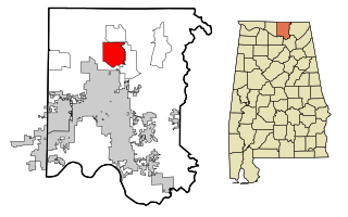
Meridianville is an unincorporated community and census-designated place (CDP) in Madison County, Alabama, United States, and is included in the Huntsville-Decatur Combined Statistical Area. As of the 2020 census, the population of the CDP was 8,209.

<span class="mw-page-title-main">Desert View Highlands, California</span> Census designated place in California, United States

Desert View Highlands is a census-designated place (CDP) in Los Angeles County, California, United States. The population was 2,360 at the 2010 census, up from 2,337 at the 2000 census. It is surrounded by the City of Palmdale.

<span class="mw-page-title-main">West Whittier-Los Nietos, California</span> Census-designated place in California, United States

West Whittier-Los Nietos is a census-designated place (CDP) in Los Angeles County, California, near the San Gabriel River and the San Gabriel River (I-605) Freeway. The population was 25,540 at the 2010 census, up from 25,129 at the 2000 census. The census area consists of separate unincorporated communities of Los Nietos and West Whittier.

<span class="mw-page-title-main">East Oakdale, California</span> Census-designated place in California, United States

East Oakdale is an unincorporated census-designated place (CDP) on the Stanislaus River, located east of the city of Oakdale in Stanislaus County, California.

<span class="mw-page-title-main">Selby-on-the-Bay, Maryland</span> Former census-designated place in Maryland, United States

Selby-on-the-Bay is a census-designated place (CDP) in Anne Arundel County, Maryland, United States, for the 2000 census, at which time its population was 3,674. It was added to the Mayo CDP for the 2010 census.

<span class="mw-page-title-main">Princeton Meadows, New Jersey</span> Populated place in Middlesex County, New Jersey, US

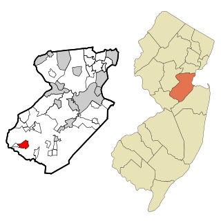
Princeton Meadows is an unincorporated community and census-designated place (CDP) located within Plainsboro Township, in Middlesex County, in the U.S. state of New Jersey. As of the 2010 United States Census, the CDP's population was 13,834.

<span class="mw-page-title-main">Leisure Village East, New Jersey</span> Populated place in Ocean County, New Jersey, US

Leisure Village East is an unincorporated community and census-designated place (CDP) located within Lakewood Township, in Ocean County, in the U.S. state of New Jersey. As of the 2010 United States Census, the CDP's population was 4,217. Leisure Village East is one of several active adult communities bearing similar names. Leisure Village and Leisure Village West are the other two communities nearby.

Delway is a census-designated place (CDP) in Sampson County, North Carolina, United States. The population was 150 at the 2020 U.S. census.

<span class="mw-page-title-main">Lake Wynonah, Pennsylvania</span> CDP in Pennsylvania, United States

Lake Wynonah is a census-designated place (CDP) in Schuylkill County, Pennsylvania, United States. The population was 1,961 at the 2000 census, and 2,640 at the 2010 census. Lake Wynonah is a gated community with two lakes, Fawn Lake and Lake Wynonah, and as of July 2008, there are over 1200 homes and 1500 members. It is in South Manheim and Wayne Townships.

<span class="mw-page-title-main">Mount Pleasant Mills, Pennsylvania</span> CDP in Pennsylvania, United States

Mount Pleasant Mills is a census-designated place (CDP) in Snyder County, Pennsylvania, United States. The population was 342 at the 2000 census.

<span class="mw-page-title-main">McGovern, Pennsylvania</span> Census-designated place in Pennsylvania, United States

McGovern is a census-designated place (CDP) in Washington County, Pennsylvania, United States. The population was 2,742 at the 2010 census.

<span class="mw-page-title-main">Wickerham Manor-Fisher, Pennsylvania</span> Census-designated place in Pennsylvania, United States

Wickerham Manor-Fisher is a census-designated place (CDP) in Washington County, Pennsylvania, United States. The population was 1,728 at the 2010 census.

<span class="mw-page-title-main">Hazel Dell North, Washington</span> Former CDP in Washington, United States

Hazel Dell North was the name of a census-designated place in Clark County, Washington, United States. The population was 9,261 at the 2000 census. For the 2010 census the U.S. Census Bureau combined Hazel Dell North and South to form a single CDP named "Hazel Dell".

<span class="mw-page-title-main">Lake Shore, Washington</span> Census-designated place in Washington, United States

Lake Shore is a census-designated place (CDP) in Clark County, Washington, United States. The population was 6,571 at the 2010 census.

<span class="mw-page-title-main">Salmon Creek, Washington</span> Census-designated place in Washington, United States

Salmon Creek is a census-designated place (CDP) in Clark County, Washington, United States. The population was 19,686 at the 2010 census, up from 16,767 at the 2000 census.

<span class="mw-page-title-main">Walnut Grove, Washington</span> Census-designated place in Washington, United States

Walnut Grove is a census-designated place (CDP) in Clark County, Washington, United States. The population was 9,790 at the 2010 census, up from 7,164 at the 2000 census.

<span class="mw-page-title-main">Piney View, West Virginia</span> Census-designated place in West Virginia, United States

Piney View is a census-designated place (CDP) in Raleigh County, West Virginia, United States. The population was 989 at the 2010 census.

<span class="mw-page-title-main">Potter Lake, Wisconsin</span> CDP in Wisconsin, United States

Potter Lake is a census-designated place (CDP) in the town of East Troy, Walworth County, Wisconsin, United States. The population was 1,117 at the 2020 census.

<span class="mw-page-title-main">West Brookfield (CDP), Massachusetts</span> Census-designated place in Massachusetts, United States

West Brookfield is a census-designated place (CDP) in the town of West Brookfield in Worcester County, Massachusetts, United States. The population was 1,413 at the 2010 census.

Seymour is a census-designated place (CDP) in Eau Claire County, Wisconsin, United States. The population was 1,418 at the 2010 census. It is located within the town of Seymour and is part of the Eau Claire urban area.

References

  1. "US Gazetteer files: 2010, 2000, and 1990". United States Census Bureau. February 12, 2011. Retrieved April 23, 2011.
  2. 1 2 "U.S. Census website". United States Census Bureau . Retrieved January 31, 2008.
  3. "CENSUS OF POPULATION AND HOUSING (17902000)". U.S. Census Bureau . Retrieved July 30, 2010.