Hazel Rymer

Last updated

Hazel Rymer
Hazel Rymer provides a response to the panel (30940543710).jpg
Alma mater University of Reading (BSc)
Open University (PhD)
Scientific career
Fields Volcanology
Institutions Open University
Thesis Gravity studies of sub-surface structures and evolution of active volcanoes in Costa Rica  (1985)
Website www.open.ac.uk/people/hr4

Hazel Rymer is a British volcanologist and Pro-Vice Chancellor at the Open University. Her research investigates how active volcanoes affect their environment and impact global climate change. She leads the citizen science project Earth Watch. [1]

Contents

Early life and education

Rymer grew up in Reading, Berkshire [2] and studied physics at the University of Reading.[ when? ] She earned her PhD in geophysics from the Open University which studied sub-surfaces of volcanoes in Costa Rica. [3] [4] She looked at the structure of pit craters in Masaya Volcano. [5]

Career and research

Rymer's research focuses on the environmental and ecological hazards posed by active volcanoes. [6] Rymer looked to track the volatile flux of the Mount Etna, Masaya and Poás volcanoes by monitoring the volcanic plume and environmental sinks. [6] [7] She chose these volcanoes because they have persistent, low levels of volcanic activity. [8] Her research looks to inform evacuation strategies and crop cultivation. [6]

Rymer developed new techniques to evaluate the size of supervolcanoes. [9] She has worked on new microgravity meters to monitor the magma inside volcanoes. [10] The gravity meters contain very sensitive spring balances. Rymer places these meters at hundreds of places across a volcano, developing a contour map that details how gravity varies in space. [10] Rymer monitored the volcanoes for extended periods of time, in an effort to monitor the movement of magma, and whether eruptions will be explosive or not. [10] She has kept one gravity meter (GM513) for thirty years. [2] She holds several patents for low-cost gravity meters. [11] [12]

She began to study Poás Volcano, which she describes as her favourite, in 1989. [13] [14] Because she has been following it for so long, she has been able to develop forecasts about when the volcano may erupt in the future. [14] She began a citizen science project with Earthwatch on Masaya volcano in Nicaragua in 2008, and has used this to engage members of the public in earth monitoring. [1] Volunteers use Global Positioning System (GPS) sensors to monitor for volcanic gases and devices that collect geoelectric information. [8] Whilst monitoring the Poás Volcano, information from the citizen scientists helped the National Park officials restrict access to the crater during the 2009 degassing. [15] These informed operational guidelines for monitoring degassing for Nicaragua and Costa Rica. [15] As part of her monitoring work, Rymer visited the Poás Volcano in January 2009 when there was a 6.2 magnitude earthquake. [6] The Poás Volcano erupted in 2009 and prevented further study. [8]

She also worked on Askja, a stratovolcano in Iceland, and observed changes in the seismic activity in 2007. She then investigated whether the magma was travelling north and whether it was accumulating below Krafla. [16] She is interested in the environmental impact of volcanoes. [1] She has investigated whether plants and soil are impacted by volcano-derived heavy elements, so-called "bio-indicators". [8] [14] She developed a molecular biology test to monitor the hairs of Tradescantia pallida , where volcanic pollution can cause a visible mutations of a recessive gene that can cause chromosomal damage in pollen. [8] Her group also use inductively coupled plasma mass spectrometry to study the concentrations of heavy elements in plant material. [8]

She served for six years on the council of the Geological Society of London. She is on the executive committee of the International Council for Open and Distance Education. [17] She contributed to the 2015 Encyclopedia of Volcanoes. [18] In 2016 Rymer appeared on The Life Scientific . [19] Rymer was appointed Pro-Vice Chancellor at the Open University in 2018. [17]

Related Research Articles

<span class="mw-page-title-main">Volcano</span> Rupture in the crust of a planet that allows lava, ash, and gases to escape from below the surface

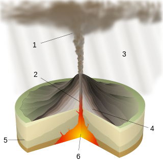
A volcano is a rupture in the crust of a planetary-mass object, such as Earth, that allows hot lava, volcanic ash, and gases to escape from a magma chamber below the surface.

<span class="mw-page-title-main">Askja</span> Volcano in Iceland

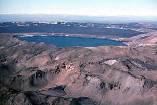
Askja ( ) is an active volcano situated in a remote part of the central highlands of Iceland. The name Askja refers to a complex of nested calderas within the surrounding Dyngjufjöll mountains, which rise to 1,514 m (4,967 ft), askja meaning box or caldera in Icelandic.

<span class="mw-page-title-main">Volcanology</span> Study of volcanoes, lava, magma and associated phenomena

Volcanology is the study of volcanoes, lava, magma and related geological, geophysical and geochemical phenomena (volcanism). The term volcanology is derived from the Latin word vulcan. Vulcan was the ancient Roman god of fire.

<span class="mw-page-title-main">Arenal Volcano</span> Active volcano in Costa Rica

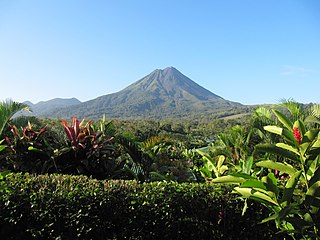
Arenal Volcano is an active andesitic stratovolcano in north-western Costa Rica around 90 km (56 mi) northwest of San José, in the province of Alajuela, canton of San Carlos, and district of La Fortuna. The Arenal volcano measures at least 1,633 metres (5,358 ft) high. It is conically shaped with a crater 140 metres (460 ft) in diameter. Geologically, Arenal is considered a young volcano and it is estimated to be less than 7,500 years old. It is also known as "Pan de Azúcar", "Canaste", "Volcan Costa Rica", "Volcan Río Frío" or "Guatusos Peak".

<span class="mw-page-title-main">Poás Volcano</span> Mountain in Costa Rica

The Poás Volcano, is an active 2,697-metre (8,848 ft) stratovolcano in central Costa Rica and is located within Poas Volcano National Park. It has erupted 40 times since 1828, including April 2017 when visitors and residents were evacuated. The volcano and surrounding park were closed for nearly 17 months, with a 2.5 kilometer safety perimeter established around the erupting crater. As of September 1, 2018 the park has reopened with limited access only to the crater observation area and requires a reservation to be made on the National Park Website. Adjacent trails to Lake Botos as well as the museum at the visitor center remained closed. The volcano erupted briefly twice in September 2019.

<span class="mw-page-title-main">Masaya Volcano</span> Active complex volcano in Nicaragua

Masaya is a caldera located in Masaya, Nicaragua, 20 km (12 mi) south of the capital Managua. It is Nicaragua's first and largest national park, and one of 78 protected areas of Nicaragua. The complex volcano is composed of a nested set of calderas and craters, the largest of which is Las Sierras shield volcano and caldera. Within this caldera lies a sub-vent, which is Masaya Volcano sensu stricto. The vent is a shield type composing of basaltic lavas and tephras and includes a summit crater. This hosts Masaya caldera, formed 2,500 years ago by an 8 km3 (1.9 cu mi) basaltic ignimbrite eruption. Inside this caldera a new basaltic complex has grown from eruptions mainly on a semi-circular set of vents that include the Masaya and Nindiri cones. The latter host the pit craters of Masaya, Santiago, Nindiri and San Pedro. Observations in the walls of the pit craters indicate that there have been several episodes of cone and pit crater formation.

<span class="mw-page-title-main">Plinian eruption</span> Type of volcanic eruption

Plinian eruptions or Vesuvian eruptions are volcanic eruptions marked by their similarity to the eruption of Mount Vesuvius in 79 AD, which destroyed the ancient Roman cities of Herculaneum and Pompeii. The eruption was described in a letter written by Pliny the Younger, after the death of his uncle Pliny the Elder.

<span class="mw-page-title-main">Irazú Volcano</span> Active volcano in Costa Rica

The Irazú Volcano is an active volcano in Costa Rica, situated in the Cordillera Central close to the city of Cartago.

<span class="mw-page-title-main">Central America Volcanic Arc</span>

The Central American Volcanic Arc is a chain of volcanoes which extends parallel to the Pacific coastline of the Central American Isthmus, from Mexico to Panama. This volcanic arc, which has a length of 1,100 kilometers is formed by an active subduction zone, with the Cocos Plate subducting underneath the Caribbean Plate. The region has been volcanically and geologically active for at least the past several million years. Numerous volcanoes are spread throughout various Central American countries; many have been active in the geologic past, some more so than others.

<span class="mw-page-title-main">Vulcanian eruption</span> Volcanic eruption with dense ash clouds

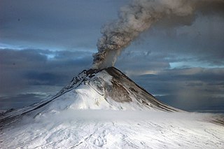
A Vulcanian eruption is a type of volcanic eruption characterized by a dense cloud of ash-laden gas exploding from the crater and rising high above the peak. They usually commence with phreatomagmatic eruptions which can be extremely noisy due to the rising magma heating water in the ground. This is usually followed by the explosive clearing of the vent and the eruption column is dirty grey to black as old weathered rocks are blasted out of the vent. As the vent clears, further ash clouds become grey-white and creamy in colour, with convolutions of the ash similar to those of Plinian eruptions.

<span class="mw-page-title-main">Volcanic gas</span> Gases given off by active volcanoes

Volcanic gases are gases given off by active volcanoes. These include gases trapped in cavities (vesicles) in volcanic rocks, dissolved or dissociated gases in magma and lava, or gases emanating from lava, from volcanic craters or vents. Volcanic gases can also be emitted through groundwater heated by volcanic action.

<span class="mw-page-title-main">Turrialba Volcano</span> Volcano in central Costa Rica

Turrialba Volcano is an active volcano in central Costa Rica that has been explosively eruptive in recent years including 2016 and in January, March and April 2017. Visitors used to be able to hike down into the main crater, but increased volcanic activity in 2014–17, resulting in large clouds of volcanic ash, caused the surrounding Turrialba Volcano National Park to close. However, with the subsiding of the eruptions, the park and volcano reopened on December 4, 2020.

<span class="mw-page-title-main">Lava lake</span> Molten lava contained in a volcanic crater

Lava lakes are large volumes of molten lava, usually basaltic, contained in a volcanic vent, crater, or broad depression. The term is used to describe both lava lakes that are wholly or partly molten and those that are solidified.

<span class="mw-page-title-main">Hōei eruption</span> Last major eruption of Mount Fuji (1707–08)

The Hōei eruption of Mount Fuji started on December 16, 1707 and ended on February 24, 1708. It was the last confirmed eruption of Mount Fuji, with three unconfirmed eruptions reported from 1708 to 1854. It is well known for the immense ash-fall it produced over eastern Japan and subsequent landslides and starvation across the country. Hokusai's One Hundred Views of Mount Fuji includes an image of the small crater at a secondary eruption site on the southwestern slope. The area where the eruption occurred is called Mount Hōei because it occurred in the fourth year of the Hōei era. Today, the crater of the main eruption can be visited from the Fujinomiya or Gotemba Trails on Mount Fuji.

<span class="mw-page-title-main">Kīlauea Iki</span> Volcano crater

Bruce F. Houghton is a New Zealand volcanologist. He was a student at Auckland University, and University of Otago, where he completed a PhD in 1977 on the geology of the Takatimu Mountains in western Southland.

<span class="mw-page-title-main">Multi-component gas analyzer system</span>

A multi-component gas analyzer system (Multi-GAS) is an instrument package used to take real-time high-resolution measurements of volcanic gases. A Multi-GAS package includes an infrared spectrometer for CO2, two electrochemical sensors for SO2 and H2S, and pressure–temperature–humidity sensors, all in a weatherproof box. The system can be used for individual surveys or set up as permanent stations connected to radio transmitters for transmission of data from remote locations. The instrument package is portable, and its operation and data analysis are simple enough to be conducted by non-specialists.

The Deep Earth Carbon Degassing (DECADE) project is an initiative to unite scientists around the world to make tangible advances towards quantifying the amount of carbon outgassed from the Earth's deep interior into the surface environment through naturally occurring processes. DECADE is an initiative within the Deep Carbon Observatory (DCO).

<span class="mw-page-title-main">Ubinas</span> Volcano in southern Peru

Ubinas is an active stratovolcano in the Moquegua Region of southern Peru, approximately 60 kilometres (37 mi) east of the city of Arequipa. Part of the Central Volcanic Zone of the Andes, it rises 5,672 metres (18,609 ft) above sea level. The volcano's summit is cut by a 1.4-kilometre-wide (0.87 mi) and 150-metre-deep (490 ft) caldera, which itself contains a smaller crater. Below the summit, Ubinas has the shape of an upwards-steepening cone with a prominent notch on the southern side. The gently sloping lower part of the volcano is also known as Ubinas I and the steeper upper part as Ubinas II; they represent different stages in the volcano's geological history.

Jenni Barclay is a professor of volcanology at the University of East Anglia. She works on ways to mitigate volcanic risks, the interactions between rainfall and volcanic activity and the communication of volcanic hazards in the Caribbean. Barclay leads the NERC-ESRC funded Strengthening Resilience to Volcanic Hazards (STREVA) research project as well as a Leverhulme Trust programme looking at the volcanic history of the Ascension Islands.

References

  1. 1 2 3 Earthwatch, Dr. Hazel Rymer Discusses Volcanos , retrieved 3 February 2019
  2. 1 2 Buckley, Anna (27 September 2018). The Life Scientific: Explorers. Orion. ISBN   9781474607490.
  3. Rymer, H.; Brown, G. C (1986). "Gravity fields and the interpretation of volcanic structures: Geological discrimination and temporal evolution". Journal of Volcanology and Geothermal Research. 27 (3): 229–254. Bibcode:1986JVGR...27..229R. doi:10.1016/0377-0273(86)90015-6. ISSN   0377-0273.
  4. Rymer, Hazel (1985). Gravity studies of sub-surface structures and evolution of active volcanoes in Costa Rica. copac.jisc.ac.uk (PhD thesis). Open University. OCLC   496958724. EThOS   uk.bl.ethos.355997.
  5. Rymer, Hazel; van Wyk de Vries, Benjamin; Stix, John; Williams-Jones, Glyn (1998). "Pit crater structure and processes governing persistent activity at Masaya Volcano, Nicaragua". Bulletin of Volcanology. 59 (5): 345–355. Bibcode:1998BVol...59..345R. doi:10.1007/s004450050196. ISSN   1432-0819. S2CID   53990763.
  6. 1 2 3 4 "Earthquake and eruptive activity at Poás volcano, Costa Rica". OpenLearn. Retrieved 3 February 2019.
  7. Locke, Corinne A.; Ferrucci, Fabrizio; Rymer, Hazel (1998). "Mount Etna: monitoring in the past, present and future". Geological Society, London, Special Publications. 143 (1): 335–347. Bibcode:1998GSLSP.143..335R. doi:10.1144/GSL.SP.1998.143.01.22. ISSN   0305-8719. S2CID   129185045.
  8. 1 2 3 4 5 6 "Volcanology and Ecology in Nicaragua" . Retrieved 3 February 2019.
  9. "Assessing the size of explosive super-eruptions: how big is big?". ukri.org. Retrieved 3 February 2019.
  10. 1 2 3 "Weighing Volcanoes with Gravity | Interviews". thenakedscientists.com. The Naked Scientists. 7 April 2010. Retrieved 3 February 2019.
  11. US 6668646,Davies, Mark; Matela, Raymond Joseph& Rymer, Hazel,"Gravity meter",issued 2003-12-30
  12. "Gravity Meter". 2004. Retrieved 2 February 2019.
  13. Morales, Louis D.; Barquero, Jorge; Stevenson, David; Kapadia, Phiroze; Dowden, John; Rymer, Hazel; Brown, Geoff (1989). "Energy budget analysis for Poás crater lake: implications for predicting volcanic activity". Nature. 339 (6223): 370–373. Bibcode:1989Natur.339..370B. doi:10.1038/339370a0. ISSN   1476-4687. S2CID   4317536.
  14. 1 2 3 GeologyLogic, Predicting Volcanoes , retrieved 3 February 2019
  15. 1 2 "REF Case study search". impact.ref.ac.uk. Retrieved 3 February 2019.
  16. "Gravity measurements of magma movements; detection of possible precursors to new eruption in Iceland". ukri.org. Retrieved 3 February 2019.
  17. 1 2 "Executive Committee Member: Hazel Rymer". icde.org. Retrieved 2 February 2019.
  18. Sigurdsson, Haraldur; Houghton, Bruce; McNutt, Stephen R.; Stix, John; Rymer, Hazel (2015). The Encyclopedia of Volcanoes - 2nd Edition. Academic Press. ISBN   978-0-12-385938-9.
  19. "The Life Scientific, Hazel Rymer on volcanoes". bbc.co.uk. BBC . Retrieved 3 February 2019.