
This list is intended to be a complete compilation of properties and districts listed on the National Register of Historic Places in Rensselaer County, New York, United States. Seven of the properties are further designated National Historic Landmarks.
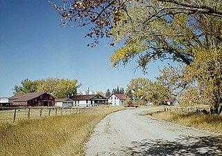
The Swan Land and Cattle Company Headquarters are a historic ranch headquarters complex on Wyoming Highway 313 in Chugwater, Wyoming. Organized in 1883 in Scotland, the Swan Company was one of the largest ranching operations in the nation in the late 19th and early 20th centuries, managing more than one million acres of land. Now a much smaller operation, its former headquarters complex was declared a National Historic Landmark in 1964.
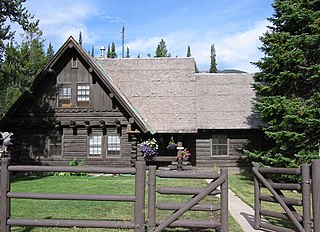
The Old Administrative Area Historic District, also known as Beaver Creek, is the former headquarters area of Grand Teton National Park. The complex of five houses, three warehouses and an administrative building were designed in the National Park Service rustic style between 1934 and 1939 and were built by the Civilian Conservation Corps and the Public Works Administration. As part of the Mission 66 program, the park headquarters were relocated to Moose, Wyoming in the 1960s.

The Geraldine Lucas–Fabian Place Historic District in Jackson Hole, Wyoming is significant as the 1913 home of Geraldine Lucas, a single woman pioneer in a harsh environment. It later became the home of Harold Fabian, vice president of the Snake River Land Company, which assembled much of the land that became Jackson Hole National Monument for John D. Rockefeller Jr.
The T E Ranch Headquarters, near Cody, Wyoming, is a log ranch house that belonged to buffalo hunter and entertainer Buffalo Bill Cody (1846–1917). The house may have originally been built by homesteader Bob Burns prior to 1895, when Cody acquired the ranch. Cody expanded the ranch to about eight thousand acres (32 km2), using the T E brand for his thousand head of cattle.
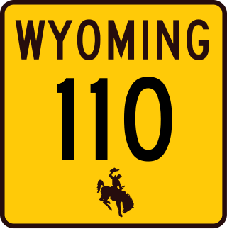
The Entrance Road at Devils Tower National Monument, officially known as Wyoming Highway 110, is a .585-mile-long (0.941 km) scenic road that provides the approach to the Devil's Tower eminence, affording planned views to arriving visitors.

This is a list of the National Register of Historic Places listings in Big Horn County, Wyoming.
This is a list of the National Register of Historic Places listings in Crook County, Wyoming.

This is a list of the National Register of Historic Places listings in Park County, Wyoming.

The Rawhide Buttes Stage Station, the Running Water Stage Station and the Cheyenne–Black Hills Stage Route comprise a historic district that commemorates the stage coach route between Cheyenne, Wyoming, and Deadwood, South Dakota. The route operated beginning in 1876, during the height of the Black Hills Gold Rush, and was replaced in 1887 by a railroad.
The Sommers Ranch Headquarters Historic District is a historic ranch complex located southwest of Pinedale, Wyoming. The district includes 11 wooden buildings, including a homestead house, a bunkhouse, a barn, and various other farm buildings and outbuildings. Albert P. "Prof" Sommers founded the ranch in 1908. Sommers married May McAlister in 1911; after the couple bought land from May's parents and her friend Nellie Yates, their ranch grew to 1,900 acres (770 ha). The ranch is still operational and serves as an example of the many ranches built in the upper Green River Valley.

The historical buildings and structures of Grand Teton National Park include a variety of buildings and built remains that pre-date the establishment of Grand Teton National Park, together with facilities built by the National Park Service to serve park visitors. Many of these places and structures have been placed on the National Register of Historic Places. The pre-Park Service structures include homestead cabins from the earliest settlement of Jackson Hole, working ranches that once covered the valley floor, and dude ranches or guest ranches that catered to the tourist trade that grew up in the 1920s and 1930s, before the park was expanded to encompass nearly all of Jackson Hole. Many of these were incorporated into the park to serve as Park Service personnel housing, or were razed to restore the landscape to a natural appearance. Others continued to function as inholdings under a life estate in which their former owners could continue to use and occupy the property until their death. Other buildings, built in the mountains after the initial establishment of the park in 1929, or in the valley after the park was expanded in 1950, were built by the Park Service to serve park visitors, frequently employing the National Park Service Rustic style of design.
The Ferris-Haggerty Mine Site was one of the richest components of the Grand Encampment Mining District in Carbon County, Wyoming. The site was first exploited by Ed Haggerty, a prospector from Whitehaven, England, in 1897 when he established the Rudefeha Mine that would later be known as the Ferris-Haggerty Mine on a rich deposit of copper ore. Haggerty was backed by George Ferris and other investors, of whom all but Ferris dropped out. The partners sold an interest to Willis George Emerson, who raised investment funding for improvements to the mine. These facilities included an engineering feat of its day by developing a 16-mile (26 km) aerial tramway to carry high grade copper mined at the Ferris-Haggerty Mine (FHM) over the Continental Divide to the smelter in Encampment. The tramway was longest aerial tramway the world had ever seen. The mine was eventually acquired by the North American Copper Company for $1,000,000 Million. By 1904 the mine had produced $1.4 million in copper ore, and was sold to the Penn-Wyoming Copper Company. However, even with copper prices peaking in 1907, the company had difficulty making a profit from the remote mine site. The company was over-capitalized and under-insured and was suffered devastating fires at the mine site in March 1906 and May 1907 which halted production. Business disputes and a fall in copper prices prevented re-opening of the mine even after it was rebuilt. Machinery was salvaged after a foreclosure in 1913. A total of 23 million pounds of copper ore was extracted from the mine during its life.

The Wardell Court Historic Residential District in Rock Springs, Wyoming is a 5-acre (2.0 ha) historic district that was listed on the U.S. National Register of Historic Places in 1997. It included 14 contributing buildings and six other buildings in a one-block area. These are all the buildings of a Wardell Court planned community that was formed by the Union Pacific Coal Company during 1920 to 1921 to house company officials. It includes Colonial Revival, Greek Revival, and Bungalow/craftsman architecture.

The F.S. King Brothers Ranch Historical District is located in the hills northeast of Laramie, Wyoming.
The Divide Sheep Camp, also known as Niland's Cabins, is a ranch site on the Little Snake River in Carbon County, Wyoming, near Baggs. The camp was established in 1909 for summer use by sheepmen of the Niland-Tierney Sheep Company and others in the Little Snake valley. Eventually becoming the Divide Sheep Company the company operated until 1974, leaving the structures intact. The principal elements are a one-story log cabin with a finished attic, measuring about 25 feet (7.6 m) by 40 feet (12

The Ohio Oil Company Building, at 159 N. Wolcott St. in Casper, Wyoming, was built in 1949. Also known as the Marathon Oil Company Building, it was listed on the National Register of Historic Places in 2001.
The J.O. Ranch Rural Historic Landscape is a historic area that incorporates the J.O. Ranch, established in 1885 in Carbon County, Wyoming. The ranch operated under the Spanish tradition of low-altitude winter ranch and high-altitude summer range. The ranching operation expanded greatly after the hard winter of 1886-87 devastated the cattle ranching industry in the area. Ranch buildings date from about 1890. Construction is log and stone, with many well-preserved structures.
The Huxtable Ranch Ranch Headquarters District, also known as White Creek Ranch, comprises a complex of ranch structures in Converse County, Wyoming. It was part of a dispersed community known as Boxelder, established by settlers in the 1880s. The ranch was established in 1893 by Charles Smith who built a one-room and later a three-room cabin on the property, as well as a barn. Three years later he sold the homestead to Willard Heber White. White and his wife lived on the ranch until 1928 when they moved to Douglas. On White's death in 1929, the ranch was purchased by Lloyd Huxtable and Charlie Olin. Lloyd and Olin built the present ranch house for Charlie and his wife Najima, Olin's sister, from 1933 to 1935. The Huxtables operated the ranch until his death at 86 in 1976. Huxtable served as a Converse County Commissioner from 1948 to 1956.
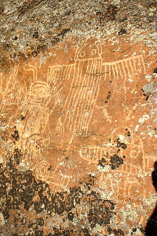
The Torrey Lake Petroglyph District extends for about 3.2 miles (5.1 km) along Torrey Creek in Fremont County, Wyoming. The site includes about 175 petroglyphs, as well as eleven lithic scatters and a sheep trap. The petroglyphs are in the Interior Line Style, or Dinwoody style, consistent with other rock art in central Wyoming. Site investigations have uncovered a number of petroglyphs that had previously been hidden under lichen. The site was placed on the National Register of Historic Places on October 4, 1993.

