Related Research Articles

Independence Rock is a large granite rock, approximately 130 feet (40 m) high, 1,900 feet (580 m) long, and 850 feet (260 m) wide, which is in southwestern Natrona County, Wyoming along Wyoming Highway 220. During the middle of the 19th century, it formed a prominent and well-known landmark on the Oregon, Mormon, and California emigrant trails. Many of these emigrants carved their names on it, and it was described by early missionary and explorer Father Pierre-Jean De Smet in 1840 as the Register of the Desert. The site was designated a National Historic Landmark on January 20, 1961 and is now part of Independence Rock State Historic Site, owned and operated by the state of Wyoming.

Oregon Trail Ruts State Historic Site is a preserved site of wagon ruts of the Oregon Trail on the North Platte River, about 0.5 miles south of Guernsey, Wyoming. The Oregon Trail here was winding up towards South Pass. Here, wagon wheels, draft animals, and people wore down the trail into a sandstone ridge about two to six feet, during its heavy usage from 1841–1869. The half-mile stretch is "unsurpassed" and is the best-preserved set of Oregon Trail ruts anywhere along its former length.

The Squirrel Meadow Guard Station is a ranger station in the backcountry of Targhee National Forest in Wyoming. The original facility was established in 1907, with the present structures built in 1934. The log cabin station is an example of a standard US Forest Service backcountry patrol structure.
The Rosencrans Cabin is part of a small historic district comprising five log buildings on three acres in Bridger-Teton National Forest, just east of Grand Teton National Park. The cabin was used by Rudolph "Rosie" Rosencrans, who played a role in the development of Teton National Forest and who later became a U.S. Forest Service administrator in the early 20th century. Rosencrans was buried at this location.
The T E Ranch Headquarters, near Cody, Wyoming, is a log ranch house that belonged to buffalo hunter and entertainer Buffalo Bill Cody (1846–1917). The house may have originally been built by homesteader Bob Burns prior to 1895, when Cody acquired the ranch. Cody expanded the ranch to about eight thousand acres (32 km²), using the T E brand for his thousand head of cattle.
The Quintin Blair House in Cody, Wyoming was designed by Frank Lloyd Wright and built in 1952-53. The house is an example of Wright's "natural house" theme, emphasizing close integration of house and landscape. It is the only Wright building in Wyoming.

Teapot Rock, also known as Teapot Dome, is a distinctive sedimentary rock formation in Natrona County, Wyoming that lent its name to a nearby oil field that became notorious as the focus of the Teapot Dome scandal, a bribery scandal during the presidential administration of Warren G. Harding. The site was listed on the National Register of Historic Places in 1974.
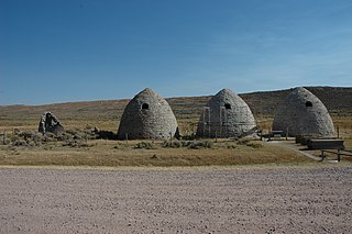
The Piedmont Charcoal Kilns in Piedmont, Wyoming, are a remnant of a once-extensive charcoal-making industry in southwestern Wyoming. The kilns were built by Moses Byrne around 1869 near the Piedmont Station along the Union Pacific Railroad. The three surviving beehive-shaped kilns were built of local sandstone about 30 feet (9.1 m) in circumference and about 30 feet (9.1 m) high, with 24-inch-thick (61 cm) walls. A granite marker reads:
Charcoal Kilns were built by Moses Byrne, 1869, to supply the pioneer smelters in the Utah Valley.

Inyan Kara Mountain is a mountain associated with the Bear Lodge Mountains of Crook County, Wyoming that is considered sacred by the Lakota people, particularly for mothers in childbirth. Inyan Kara stands apart from the main body of the Black Hills, with an elevation of 6,368 feet (1,941 m). The mountain was stated to rumble on quiet days by the local Native Americans and by early explorers. No mention of the noises are found after 1833; the noise has been attributed to gas escaping from burning coal seams.

The Wyoming Territorial Prison is a former federal government prison near Laramie, Wyoming. Built in 1872, it is one of the oldest buildings in Wyoming. It operated as a federal penitentiary from 1872 to 1890, and as a state prison from 1890 to 1901. It was then transferred to the University of Wyoming and was used as an agricultural experiment station until 1989. In 1991, the facility was opened to the public, and in 2004, it was designated as Wyoming Territorial Prison State Historic Site.
Granger Station State Historic Site, also known as Granger Stage Station, South Bend Station and Ham's Fork Station, is a Wyoming state park dedicated to the interpretation of the station, the Pony Express and the Overland Trail. A settlement was first established about 1856 at the meeting of Ham's Fork with Black's Fork of the Green River, where a ferry crossed Ham's Fork. This became a station on the Pony Express in 1860-1861, then was a station on the Overland Trail in 1862. By this time it was known as the South Bend Station. In 1868 the trail was superseded when the Union Pacific Railroad arrived at the site. The station was deeded to the State of Wyoming in 1930. It is operated as a state historic site. The Granger Station was placed on the National Register of Historic Places on February 26, 1970.
The Divide Sheep Camp, also known as Niland's Cabins, is a ranch site on the Little Snake River in Carbon County, Wyoming, near Baggs. The camp was established in 1909 for summer use by sheepmen of the Niland-Tierney Sheep Company and others in the Little Snake valley. Eventually becoming the Divide Sheep Company the company operated until 1974, leaving the structures intact. The principal elements are a one-story log cabin with a finished attic, measuring about 25 feet (7.6 m) by 40 feet (12 m) built in the early 1920s, a log bunkhouse dating to about 1914, a spring house and a generator shed. The site represents a moderately-well-preserved turn-of-the-century sheep camp.
The Duck Lake Station Site is a former way station on the Overland Trail in Carbon County, Wyoming. Built in 1862, the site is located between the Dug Springs Station to the west and the Washakie Station to the east. Stations on the trail were typically about 15 miles (24 km) apart with the largest, most elaborate stations at 50-mile (80 km) intervals. The Duck Lake station was a more basic one-room building. All that remains of the station are its foundations. The site was placed on the National Register of Historic Places on December 6, 1978.
The Sage Creek Station Site is a former way station on the Overland Trail in Carbon County, Wyoming. Constructed about 1862, the station was built of logs with an adobe fireplace and a dirt roof over pole rafters. The site burned on June 8, 1865, but may have been rebuilt. All that remains of the station are its foundations. The site was placed on the National Register of Historic Places on December 6, 1978.
The Midway Station Site is a former way station on the Overland Trail in Carbon County, Wyoming. Built in 1850, the station was on a heavily traveled stage and emigration route, halfway between Saratoga and Walcott, providing its name. Nothing remains of the station beyond depressions in the earth. The site was placed on the National Register of Historic Places on December 6, 1978.
The Washakie Station Site is a former way station on the Overland Trail in Carbon County, Wyoming. Built in 1862, the station was on a heavily traveled stage and emigration route. The station was a stone structure with a dirt roof over pole rafters. Remains of the station consist of foundations and ruined sandstone walls. The site was placed on the National Register of Historic Places on December 6, 1978.
The Laclede Station Ruin is a former way station on the Overland Trail in Sweetwater County, Wyoming, between the Big Pond Station and the Dug Springs Station. Constructed in the 1860s, the station was built of stone slabs. The ruins of some of its walls remain. The site was placed on the National Register of Historic Places on December 6, 1978.
The Dug Springs Station Site is a former way station on the Overland Trail in Sweetwater County, Wyoming. Constructed about 1862, the station was built with rock slab walls, between Laclede Station and Duck Lake Station. The site was placed on the National Register of Historic Places on December 6, 1978.
The Dorr Ranch was established by William and Mabel Dorr in 1910 in Converse County, Wyoming along Woody Creek. William had left home at the age of 8 or 9 and worked for the 71 Quarter Ranch and as a horse wrangler at Pony Express stations in Wyoming. He met Mabel McIntosh and married her in 1904. Mabel's parents had established the successful Hat Ranch near Split Rock and had significant resources to assist the young couple. The Dorrs filed for their first homestead in 1910 and expanded it in 1915, and again in 1917 and 1919, with a separate 1919 filing by Mabel. The Dorr's properties were not contiguous, and the present ranch house on Woody Creek was not built until 1915. In 1919 the Dorr School was built on the ranch. The same year the community of Bill was established, named after the shared name of four of the founders. The main ranch house was built in 1926–27.

The Tolar Petroglyph Site is an archeological site in Sweetwater County, Wyoming. The site includes a sandstone rock formation with 32 panels of petroglyphs running for 150 feet (46 m) along the rock face. Many of the illustrations are of horse-mounted people of the Plains Indians in historical times. Other motifs include the turtle motif, spirit bear and shield-carrying warriors.
References
- 1 2 "National Register Information System". National Register of Historic Places . National Park Service. July 9, 2010.
- ↑ "Pine Grove Station Site". Wyoming State Historic Preservation Office.