
Batley is a market town in the Metropolitan Borough of Kirklees, in West Yorkshire, England. Batley lies south-west of Leeds, north-west of Wakefield and Dewsbury, south-east of Bradford and north-east of Huddersfield. Batley is part of the Heavy Woollen District. In 2011 the population of Batley including Hanging Heaton, Staincliffe, Carlinghow, Birstall, Birstall Smithies, Copley Hill and Howden Clough was 48,730.

Dewsbury is a minster and market town in the Metropolitan Borough of Kirklees in West Yorkshire, England. It lies on the River Calder and on an arm of the Calder and Hebble Navigation waterway. It is to the west of Wakefield, east of Huddersfield and south of Leeds.

Ossett is a market town in West Yorkshire, England, within the City of Wakefield. Historically part of the West Riding of Yorkshire, it is situated between Dewsbury, Horbury and Wakefield. At the 2021 census, the town had a population of 21,861. Ossett forms part of the Heavy Woollen District.

Kirklees is a metropolitan borough of West Yorkshire, England. The borough compromises of the eight towns of Batley, Birstall, Cleckheaton, Dewsbury, Heckmondwike, Holmfirth, Huddersfield, Mirfield and Slaithwaite. It is governed by Kirklees Council. Kirklees had a population of 422,500 in 2011; it is the third largest metropolitan district in England by area size, behind Doncaster and Leeds.
Lawrence Batley Theatre is a theatre in Huddersfield, West Yorkshire, England which offers drama, music, dance and comedy.

Batley and Spen is a constituency in the House of Commons of the UK Parliament. The current MP is Kim Leadbeater, a Labour politician, elected in a 2021 by-election by a 323-vote margin. The seat has returned Labour MPs since the 1997 general election.
Birstall is a market and mill town in the metropolitan borough of Kirklees, West Yorkshire, England. It is part of the Birstall and Birkenshaw ward, which had a population of 16,298 at the 2011 census. Historically in the West Riding of Yorkshire, and part of the Heavy Woollen District, Birstall is approximately 6 miles (10 km) south-west of Leeds and situated close to the M62 motorway. The town is situated between Leeds, Bradford, Huddersfield and Wakefield.

Dewsbury railway station serves the town of Dewsbury in West Yorkshire, England. Situated 9.25 miles (15 km) south west of Leeds on the main line to Huddersfield and Manchester, the station was opened by the London and North Western Railway in 1848.
Kirklees Council is the local authority for the metropolitan borough of Kirklees in West Yorkshire, England. Since the last boundary changes in 2004, the council has comprised 69 councillors representing 23 wards. Elections are held three years out of four, with one third of the councillors elected each time for a four-year term.
Berry Brow is a semi-rural village in West Yorkshire, England, situated about 2 miles (3 km) south of Huddersfield. It lies on the eastern bank of the Holme Valley and partially straddles the A616 road to Honley and Penistone.

Kirklees Council is the local authority providing most local government services for the metropolitan borough of Kirklees in West Yorkshire, England. The council is one of five constituent members of the West Yorkshire Combined Authority.

Kirklees College is a further education college with two main centres in the towns of Dewsbury and Huddersfield in West Yorkshire, England.

Drub is a hamlet in the Kirklees district, in the county of West Yorkshire, England. It is located between Cleckheaton, Birkenshaw, and Gomersal and is considered part of the latter.

Beggarington Hill is a hamlet in the county of West Yorkshire, England, in the City of Leeds and at the border of Kirklees. Historically, it was part of the West Ardsley civil parish. It is located immediately southwest of West Ardsley near the town of Batley, between Baghill Beck in the north and Hey Beck in the south. The A653 road runs approximately 0.6 miles (1.0 km) west of the settlement.
Batley Girls' High School is a secondary school and sixth form in Batley, West Yorkshire, England.
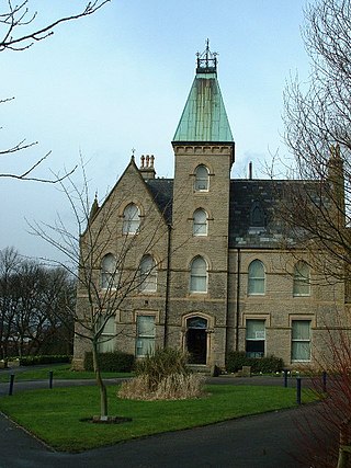
Bagshaw Museum is a local museum in the town of Batley, West Yorkshire. Situated in Wilton Park, the elaborate Gothic Revival mansion was converted into a museum by Walter Bagshaw in 1911. Originally called the Wilton Park Museum, it was renamed after Bagshaw following his death in 1927.
The Heavy Woollen District Independents was a political party based in the Heavy Woollen District of West Yorkshire, England. The party was registered with the Electoral Commission on 13 September 2017. Its leader was Aleksandar Lukic-Scott, who was the chairman for UKIP's Dewsbury, Batley and Spen branch until 2017.

The 2021 Kirklees Metropolitan Borough Council election took place on 6 May 2021 to elect members of Kirklees Metropolitan Borough Council in England. This was on the same day as other local elections. One-third of the seats were up for election, with two wards Almondbury electing two councillors. In November 2020, 3 Labour Councillors resigned in protest over the handling of the suspension of Jeremy Corbyn. This resulted in Labour losing overall control of Kirklees Council.
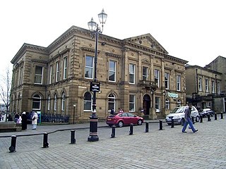
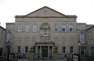
Batley Town Hall is a municipal facility in the Market Place in Batley, West Yorkshire, England. It is a Grade II listed building.

