
Bijnor district is one of the 75 districts in the state of Uttar Pradesh in India. Bijnor city is the district headquarters. The government of Uttar Pradesh seeks it to be included in National Capital Region (NCR) due to its close proximity to NCT of Delhi.
Nagina is a town and a municipal board in Bijnor district in the Indian state of Uttar Pradesh.

Bikaner District is a district of the state of Rajasthan in western India. The historic city of Bikaner is the district headquarters. The district is located in Bikaner Division along with the three other districts of Churu, Sri Ganganagar and Hanumangarh.
Afzalgarh is a city and a municipal board in Bijnor district in the Indian state of Uttar Pradesh. It is located at the border with the state of Uttarakhand.
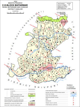
Bhitarwar is a city and a Municipality in Gwalior district in the state of Madhya Pradesh, India. The town is surrounded by a river called Parbati.
Dhampur is a city and a municipal board in Bijnor district in the state of Uttar Pradesh, India. It is located at 29.51°N 78.50°E, and lies in Northern India.
Jaspur is a developing town and a municipal board in Udham Singh Nagar district in the Indian state of Uttarakhand.

Lohaghat is a town and a nagar palika in Champawat district in the Indian state of Uttarakhand.
Nehtaur is a city, near Bijnor city in Bijnor district in the northern Indian state of Uttar Pradesh. Nehtaur is an ancient and well known town because of its culture and educational backgrounds. Nehtaur Town was established by the Taga Minister family of Ajmer state when they came from Ranthambhor, Rajasthan after it was captured by Qutubuddin Aibak and the place was called Nai+thour = NEHTAUR. This is how Nehtaur derived its name [Ref. Book-History of Islam in India].
Noorpur is a City and a Municipal Board in Bijnor District in the Indian State of Uttar Pradesh.

Purwa is a town and nagar panchayat in Unnao district, Uttar Pradesh, India. It is located 32 km southeast of Unnao, the district headquarters. Roads connect it with several major cities including Unnao, Lucknow, Kanpur, and Rae Bareli. As of 2011, its population is 24,467 people, in 4,128 households.
Rithora is a town and a nagar panchayat in Bareilly Tehsil of Bareilly district in the Indian state of Uttar Pradesh.
Seohara is a town and a municipal board situated between Sahaspur and Dhampur in Bijnor district in the Indian state of Uttar Pradesh.
Sherkot is a city and Municipal board in the Bijnor of the Indian state of Uttar Pradesh.

Salon is a town and nagar panchayat in Raebareli district in the Indian state of Uttar Pradesh. It serves as the headquarters of a tehsil as well as a community development block. Originally it was also the headquarters of the entire district, but they were moved after the Indian Rebellion of 1857. It is located a bit to the south of the Sai river, at the junction of the Raebareli-Pratapgarh and Jais-Khaga roads. Other roads lead to Dalmau, Manikpur, and Kunda. To the east is a large jhil.
Harewali is a village located at Bijnor district of Uttar Pradesh.
Ghansali is located in Ghansali Tehsil of Tehri Garhwal district in Uttarakhand, India. Ghansali town offers a splendid beauty of Bhilangana River on one side and dense forest at other. According to the 2011 census it has a population of 392 living in 82 households. Its main agriculture product is paddy growing.
Suawala is a village of the Bijnor district, Uttar Pradesh, India. It is located at the border with the state of Uttarakhand. Pin Code is 246747. Tehsil Dhampur and Block Afzalgarh.
Chelapur is a village and gram panchayat in Chandpur tehsil, Bijnor District, in the Indian state of Uttar Pradesh.
Ramgarh (community development block) is an administrative division in the Ramgarh subdivision of the Ramgarh district in the Indian state of Jharkhand.

