This is a list of sites in Minnesota which are included in the National Register of Historic Places. There are more than 1,700 properties and historic districts listed on the NRHP; each of Minnesota's 87 counties has at least 2 listings. Twenty-two sites are also National Historic Landmarks.

This is a list of the National Register of Historic Places listings in Dakota County, Minnesota. It is intended to be a complete list of the properties and districts on the National Register of Historic Places in Dakota County, Minnesota, United States. Dakota County is located in the southeastern part of the U.S. state of Minnesota, bounded on the northeast side by the Upper Mississippi River and on the northwest by the Minnesota River. The locations of National Register properties and districts for which the latitude and longitude coordinates are included below, may be seen in an online map.

This is a list of the National Register of Historic Places listings in Stearns County, Minnesota. It is intended to be a complete list of the properties and districts on the National Register of Historic Places in Stearns County, Minnesota, United States. The locations of National Register properties and districts for which the latitude and longitude coordinates are included below, may be seen in an online map.

This is a list of the National Register of Historic Places listings in Blue Earth County, Minnesota. It is intended to be a complete list of the properties and districts on the National Register of Historic Places in Blue Earth County, Minnesota, United States. The locations of National Register properties and districts for which the latitude and longitude coordinates are included below, may be seen in an online map.

This is a list of the National Register of Historic Places listings in Morrison County, Minnesota. It is intended to be a complete list of the properties and districts on the National Register of Historic Places in Morrison County, Minnesota, United States. The locations of National Register properties and districts for which the latitude and longitude coordinates are included below, may be seen in an online map.

This is a list of the National Register of Historic Places listings in Fillmore County, Minnesota. It is intended to be a complete list of the properties and districts on the National Register of Historic Places in Fillmore County, Minnesota, United States. The locations of National Register properties and districts for which the latitude and longitude coordinates are included below, may be seen in an online map.

This is a list of the National Register of Historic Places listings in Wabasha County, Minnesota. It is intended to be a complete list of the properties and districts on the National Register of Historic Places in Wabasha County, Minnesota, United States. The locations of National Register properties and districts for which the latitude and longitude coordinates are included below, may be seen in an online map.

This is a list of the National Register of Historic Places listings in Clay County, Minnesota. It is intended to be a complete list of the properties and districts on the National Register of Historic Places in Clay County, Minnesota, United States. The locations of National Register properties and districts for which the latitude and longitude coordinates are included below, may be seen in an online map.
This is a list of the National Register of Historic Places listings in Houston County, Minnesota. It is intended to be a complete list of the properties and districts on the National Register of Historic Places in Houston County, Minnesota, United States. The locations of National Register properties and districts for which the latitude and longitude coordinates are included below, may be seen in an online map.

This is a list of the National Register of Historic Places listings in Kandiyohi County, Minnesota. It is intended to be a complete list of the properties and districts on the National Register of Historic Places in Kandiyohi County, Minnesota, United States. The locations of National Register properties and districts for which the latitude and longitude coordinates are included below, may be seen in an online map.

This is a list of the National Register of Historic Places listings in Becker County, Minnesota. It is intended to be a complete list of the properties and districts on the National Register of Historic Places in Becker County, Minnesota, United States. The locations of National Register properties and districts for which the latitude and longitude coordinates are included below may be seen in an online map.

This is a list of the National Register of Historic Places listings in Steele County, Minnesota. It is intended to be a complete list of the properties and districts on the National Register of Historic Places in Steele County, Minnesota, United States. The locations of National Register properties and districts for which the latitude and longitude coordinates are included below, may be seen in an online map.

This is a list of the National Register of Historic Places listings in Meeker County, Minnesota.
This is a list of the National Register of Historic Places listings in Beltrami County, Minnesota. This is intended to be a complete list of the properties and districts on the National Register of Historic Places in Beltrami County, Minnesota, United States. The locations of National Register properties and districts for which the latitude and longitude coordinates are included below, may be seen in an online map.

This is a list of the National Register of Historic Places listings in Big Stone County, Minnesota. It is intended to be a complete list of the properties and districts on the National Register of Historic Places in Big Stone County, Minnesota, United States. Latitude and longitude coordinates are provided for many National Register properties and districts; these locations may be seen together in an online map.

This is a list of the National Register of Historic Places listings in Martin County, Minnesota. It is intended to be a complete list of the properties and districts on the National Register of Historic Places in Martin County, Minnesota, United States. The locations of National Register properties and districts for which the latitude and longitude coordinates are included below, may be seen in an online map.

The Henderson Community Building, also known as the Old Sibley County Courthouse, is a historic government building in Henderson, Minnesota, United States. It was built in 1879 and served as the home of Sibley County's government until 1915, when the county seat was relocated to Gaylord, Minnesota.

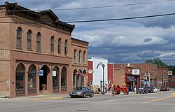
The Sibley County Courthouse and Sheriff's Residence and Jail are two adjacent government buildings in Gaylord, Minnesota, United States. They were built in 1916 and serve as the seat of government for Sibley County. An annex to the courthouse was added in 1976.

The August F. Poehler House is a historic house in Henderson, Minnesota, United States. It was built in 1884 for shopowners August and Emilie Poehler and their six children. Since 1949 the house has served as the Sibley County Historical Society Museum.

The Church of St. Thomas is a former Roman Catholic church complex in Jessenland Township, Minnesota, United States. It consists of an 1870 church, 1878 rectory, and a hillside cemetery whose oldest tombstone is dated 1856. Together they are remnants of the very first agricultural settlement established by Irish Americans in Minnesota, founded here along the Minnesota River in 1852. The complex was listed on the National Register of Historic Places in 1991 for its local significance in the theme of European ethnic heritage. It was nominated for its association with Minnesota's first Irish-American farming settlement and one of the first agricultural communities in Sibley County. In 2023, the Diocese of New Ulm closed the oratory and sold the building to a non-profit organization named Friends of Jessenland. Their mission is to create an Irish cultural center. The cemetery remains in perpetual care of the Diocese.