
The San Juan Mountains are a high and rugged mountain range in the Rocky Mountains in southwestern Colorado and northwestern New Mexico. The area is highly mineralized and figured in the gold and silver mining industry of early Colorado. Major towns, all old mining camps, include Creede, Lake City, Silverton, Ouray, and Telluride. Large scale mining has ended in the region, although independent prospectors still work claims throughout the range. The last large scale mines were the Sunnyside Mine near Silverton, which operated until late in the 20th century and the Idarado Mine on Red Mountain Pass that closed down in the 1970s. Famous old San Juan mines include the Camp Bird and Smuggler Union mines, both located between Telluride and Ouray.

The Town of Lake City is the Statutory Town that is the county seat and the only incorporated municipality in Hinsdale County, Colorado, United States. It is located in the San Juan Mountains in a valley formed by the convergence of Henson Creek and the headwaters of the Lake Fork of the Gunnison River about seven miles (11 km) east of Uncompahgre Peak, a Colorado fourteener. Lake City is named after nearby Lake San Cristobal. This area lies at the southern end of the Colorado Mineral Belt and when rich mineral deposits were discovered the native population was pushed from their tribal lands and the town of Lake City was incorporated in 1873.

The Western Slope refers to a region of the state of Colorado incorporating everything in the state west of the Continental Divide. Bodies of water west of the Divide flow toward the Pacific Ocean. Water that falls and flows east of the Divide heads east. The Western Slope encompasses about 33% of the state, but has just 10% of the state's residents. The eastern part of the state, including the San Luis Valley and the Front Range is the more populous portion of the state.

The North Platte River is a major tributary of the Platte River and is approximately 716 miles (1,152 km) long, counting its many curves. In a straight line, it travels about 550 miles (890 km), along its course through the U.S. states of Colorado, Wyoming, and Nebraska.

The Green River, located in the western United States, is the chief tributary of the Colorado River. The watershed of the river, known as the Green River Basin, covers parts of Wyoming, Utah, and Colorado. The Green River is 730 miles (1,170 km) long, beginning in the Wind River Mountains of Wyoming and flowing through Wyoming and Utah for most of its course, except for 40 miles (64 km) into western Colorado. Much of the route is through the Colorado Plateau and through some of the most spectacular canyons in the United States. It is only slightly smaller than the Colorado when the two rivers merge, but typically carries a larger load of silt. The average yearly mean flow of the river at Green River, Utah is 6,121 cubic feet (173.3 m3) per second.

The Sevier River is a 385-mile (620 km)-long river in the Great Basin of southwestern Utah in the United States. Originating west of Bryce Canyon National Park, the river flows north through a chain of high farming valleys and steep canyons along the west side of the Sevier Plateau, before turning southwest and terminating in the endorheic basin of Sevier Lake in the Sevier Desert. It is used extensively for irrigation along its course, with the consequence that Sevier Lake is usually dry.

Animas River (On-e-mas) is a 126-mile-long (203 km) river in the western United States, a tributary of the San Juan River, part of the Colorado River System.
Uncompahgre Peak is the sixth highest summit of the Rocky Mountains of North America and the U.S. state of Colorado. The prominent 14,321-foot (4365.0 m) fourteener is the highest summit of the San Juan Mountains and the highest point in the drainage basin of the Colorado River and the Gulf of California. It is located in the Uncompahgre Wilderness in the northern San Juans, in northern Hinsdale County approximately 7 miles (11 km) west of the town of Lake City.

Crystal is a ghost town on the upper Crystal River in Gunnison County, Colorado, United States. It is located in the Elk Mountains along a four-wheel-drive road 6 miles (9.7 km) east of Marble and 20 miles (32 km) northwest of Crested Butte. Crystal was a mining camp established in 1881 and after several decades of robust existence, was all but abandoned by 1917. Many buildings still stand in Crystal, but its few residents live there only in the summer.

Thistle is a ghost town in Spanish Fork Canyon in southeastern Utah County, Utah, United States. During the era of steam locomotives, the town's primary industry was servicing trains for the Denver and Rio Grande Western Railroad. The fortunes of the town were closely linked with those of the railroad until the changeover to diesel locomotives, when the town started to decline.

The Rio Chama, a major tributary river of the Rio Grande, is located in the U.S. states of Colorado and New Mexico. The river is about 130 miles (210 km) long altogether. From its source to El Vado Dam its length is about 50 miles (80 km), from El Vado Dam to Abiquiu Dam is about 51 miles (82 km), and from Abiquiu Dam to its confluence with the Rio Grande is about 34 miles (55 km).
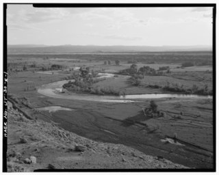
The Lake Fork of the Gunnison River begins in high mountains in the western region of the U.S. state of Colorado, draining the northeastern part of the San Juan Mountains.
The Central Utah Project is a US federal water project that was authorized for construction under the Colorado River Storage Project Act of April 11, 1956, as a participating project. In general, the Central Utah Project develops a portion of Utah's share of the yield of the Colorado River, as set out in the Colorado River Compact of 1922.

Henson is a ghost town in Hinsdale County, Colorado, United States. Its elevation is 9,235 feet (2,815 m). Henson's name has historically been spelled several different ways, including Hansen, Hanson, Hensen, and Honsen; the Board on Geographic Names officially supported the current spelling in 1896. Henson was named for Henson Creek, which was named for a pioneer settler.
Tarryall is a ghost town in northwest Park County, Colorado, United States. It is on upper Tarryall Creek northwest of Como, Colorado. It was once the county seat of Park County, but is now completely deserted.

The Piedra River is a river in the U.S. state of Colorado. It drains parts of Archuleta, Hinsdale, and Mineral counties along a mainstem length of about 40 miles (64 km). The river flows through a series of isolated box canyons, emptying into the San Juan River at Navajo Lake. Its name stems from the Spanish word, piedra, meaning rock.

Lake San Cristobal is a lake in the U.S. state of Colorado. Located in the San Juan Mountains at an elevation of 9,003 feet (2,744 m), the freshwater lake is 2.1 miles (3.4 km) long, up to 89 feet (27 m) deep, has a surface area of 0.52 square miles (1.3 km2), and holds about 11,000 acre feet (14,000,000 m3) of water. The town of Lake City, a few miles to the north, is named after Lake San Cristobal. The name San Cristóbal means Saint Christopher in the Spanish language. Many old silver mines are near the lake and it is very clean and well kept, and stocked with Rainbow Trout.
The Duchesne River, located in the Uintah Basin region of Utah in the western United States, is a tributary of the Green River. The watershed of the river covers the Northeastern corner of Utah. The Duchesne River is 115 miles (185 km) long, and drains a total land area of 3,790 square miles (9,800 km2).
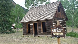
Capitol City is a ghost town in Hinsdale County, Colorado, on the Alpine Loop National Scenic Back Country Byway.

Independence is a ghost town in the U.S. state of Colorado. It is located just off State Highway 82 in the eastern corner of Pitkin County, below the Continental Divide. It was the first settlement established in the Roaring Fork Valley, after gold was struck in the vicinity on Independence Day, July 4, 1879, hence its name. In 1973 it was recognized as a historic district and listed on the National Register of Historic Places as Independence and Independence Mill Site, one of two ghost towns in the county so recognized. It has also been known historically by other names—Chipeta, Mammoth City, Mount Hope, Farwell, Sparkill and Hunter's Pass.

