Herman, Arkansas

Last updated

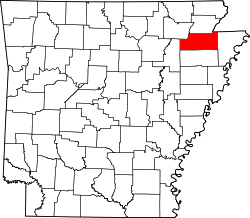
Herman is an unincorporated community in Craighead County, Arkansas, United States. Its location is 35°42′54″N90°31′56″W / 35.71500°N 90.53222°W / 35.71500; -90.53222 .

Etymology

The locale of Herman began as a railroad stop, with the post office being called Bellefield. The name of the railroad stop was changed to Herman by Francis John Borgman, who owned a lumber mill and ran the post office at this railroad stop which was right at his house, after his son John Allen Borgman had a baby boy named Herman in 1898.

In the early 1900s, Frank Borgman petitioned the United States Postal Service to also change the post office to Herman but they declined, responding that it was too similar to the post office of Harman nearby. But in 1920, after Herman Francis Borgman married, the post office changed its name to Herman.

Related Research Articles

<span class="mw-page-title-main">Forrest City, Arkansas</span> City in Arkansas, United States

Forrest City is a city in St. Francis County, Arkansas, United States, and the county seat. It was named for General Nathan Bedford Forrest, a notable Confederate military leader. Shortly after the end of the Civil War, he had a construction crew camped here, who were completing a railroad between Memphis and Little Rock.

<span class="mw-page-title-main">Raymer, Colorado</span> Town in Colorado, United States

The Town of Raymer is a Statutory Town located in Weld County, Colorado, United States. The population was 110 at the U.S. Census 2020.

<span class="mw-page-title-main">Henrietta Township, Michigan</span> Civil township in Michigan, United States

Henrietta Township is a civil township of Jackson County in the U.S. state of Michigan. The population was 4,705 at the 2010 census.

<span class="mw-page-title-main">Clinton, Montana</span> CDP in Montana, United States

Clinton is a census-designated place (CDP) in Missoula County, Montana, United States. It is part of the 'Missoula, Montana Metropolitan Statistical Area'. The CDP was named for General Sir Henry Clinton. The population was 1,052 at the 2010 census, an increase from its population of 549 in 2000.

<span class="mw-page-title-main">Ethridge, Tennessee</span> Town in Tennessee, United States

Ethridge is a town in Lawrence County, Tennessee, United States. The population was 465 at the 2010 census, down from 536 at the 2000 census.

<span class="mw-page-title-main">Groesbeck, Texas</span> Town in Texas, United States

Groesbeck is a city in and the county seat of Limestone County, Texas, United States. Its population was 3,631 at the 2020 census. The community is named after a railroad employee.

Budapest is a small unincorporated community in Haralson County in the U.S. state of Georgia. It is located at an elevation of 1,362 feet (415 m). Budapest is located] on U.S. Route 78, about five miles (8 km) southeast of Tallapoosa.

<span class="mw-page-title-main">53rd United States Congress</span> 1893-1895 U.S. Congress

The 53rd United States Congress was a meeting of the legislative branch of the United States federal government, consisting of the United States Senate and the United States House of Representatives. It met in Washington, D.C., from March 4, 1893, to March 4, 1895, during the first two years of Grover Cleveland's second presidency. The apportionment of seats in the House of Representatives was based on the 1890 United States census.

Dukedom is an unincorporated community in both Graves County, Kentucky and Weakley County, Tennessee, straddling the state line in the western part of both states. The location is 36°30′8″N88°42′54″W; The elevation is 487 feet above sea level.

Missouri's second congressional district is in the eastern portion of the state, primarily consisting of the suburbs south and west of St. Louis, including Arnold, Town and Country, Wildwood, Chesterfield, and Oakville. The district includes all of Franklin County and portions of St. Louis, St. Charles, and Warren counties. Following redistricting in 2010, the St. Louis Post-Dispatch reported that the district now included more Democratic-leaning voters than it had its 2001–2010 boundaries, but still leaned Republican as a whole. The latest U.S. Census Electorate Profile for the 2nd congressional district estimates there are 581,131 citizens of voting age living in 293,984 households. A primarily suburban district, MO-02 is the wealthiest of Missouri's congressional districts.

The Village of Holly Bluff is a small unincorporated community in Yazoo County, Mississippi.

<span class="mw-page-title-main">Martinsburg Township, Pike County, Illinois</span> Township in Illinois, United States

Martinsburg Township is located in Pike County, Illinois. As of the 2010 census, its population was 419 and it contained 186 housing units.

Steubenville is an unincorporated community in Steuben Township, Steuben County, in the U.S. state of Indiana.

<span class="mw-page-title-main">Canyon Diablo, Arizona</span> Ghost town in Coconino County, Arizona

Canyon Diablo is a ghost town in Coconino County, Arizona, United States on the edge of the arroyo Canyon Diablo. The community was settled in 1880 and died out in the early 20th century.

<span class="mw-page-title-main">South Woodstock, Vermont</span> Census-designated place in Vermont, United States

South Woodstock is an unincorporated village and census-designated place (CDP) in the town of Woodstock in Windsor County, Vermont, United States. Its elevation is 1,040 feet (320 m), and it is located at 43°33′56″N72°31′56″W, in the Kedron Valley.

<span class="mw-page-title-main">Antigo Air Force Station</span> Closed United States Air Force General Surveillance Radar station

Antigo Air Force Station is a closed United States Air Force General Surveillance Radar station. It is located 7.5 miles (12.1 km) south-southwest of Antigo, Wisconsin. It was closed in 1977 and is currently classified as a high risk toxic waste site involving groundwater, sediment, soil and surface water.

<span class="mw-page-title-main">South Atlanta</span> Neighborhoods of Atlanta in Fulton County, Georgia, United States

South Atlanta is an officially defined neighborhood of the city of Atlanta within the city's south side. It is bounded on the northeast by the railroad and the Chosewood Park neighborhood; on the northwest by the railroad and the BeltLine and the Peoplestown neighborhood, on the west by High Point and the Villages at Carver, and on the south mostly by Turman Street and the Lakewood Heights neighborhood.

Cabanal is a community in Carroll County in northwest Arkansas, United States. The community is located on Arkansas Highway 21, south of Berryville and north of Metalton. The site is along a north flowing tributary to Osage Creek below and west of Gage Mountain at an elevation of 1,306 ft (398 m).

Osage is a ghost town in northwestern Colorado County in the U.S. state of Texas. The one-time settlement was situated on Harvey Creek near the junction of County Roads 205 and 208 a few miles to the northeast of Weimar. At the time of the American Civil War, the community was substantial enough to provide a company of soldiers to a Texas regiment in the Confederate States Army. A notable school flourished in Osage starting in the 1870s, but in that decade the railroad was built through Weimar instead. By 1900 the local commercial establishments had moved to Weimar and the town faded out of existence. In 2013 the area was sparsely settled.

<span class="mw-page-title-main">Bessville, Missouri</span> Unincorporated community in the American state of Missouri

Bessville is an unincorporated community in the southern part of Crooked Creek Township in eastern Bollinger County, Missouri, United States. The community lies on the east bank of Crooked Creek and at the end of Missouri Route OO. It is located approximately seven miles northwest of Marble Hill and 5.5 miles southeast of Marquand in adjacent Madison County.