Bono, Arkansas

Last updated

Bono, Arkansas
Bono AR 015.jpg
Bono City Hall, July 2011
Craighead County Arkansas Incorporated and Unincorporated areas Bono Highlighted 0507630.svg
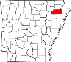
Location of Bono in Craighead County, Arkansas.
Coordinates: 35°54′40″N90°48′03″W / 35.91111°N 90.80083°W / 35.91111; -90.80083
Country United States
State Arkansas
County Craighead
Area
[1]
  Total2.66 sq mi (6.90 km2)
  Land2.66 sq mi (6.90 km2)
  Water0.00 sq mi (0.00 km2)
Elevation
[2]
262 ft (80 m)
Population
 (2020)
  Total2,409
  Density904.28/sq mi (349.20/km2)
Time zone UTC-6 (Central (CST))
  Summer (DST) UTC-5 (CDT)
ZIP Code
72416
Area code 870
FIPS code 05-07630
GNIS feature ID2403895 [2]
Website bonoar.com

Bono is a city in Craighead County, Arkansas, United States. The population was 2,131 at the 2010 census, [3] up from 1,512 in 2000. It is included in the Jonesboro, Arkansas Metropolitan Statistical Area. Bono's most prominent landmarks are the Bono Bridge and the Bono Cemetery.

Contents

Geography

Bono Post office Bono AR 012.jpg
Bono Post office

Bono is located in northwestern Craighead County 8 miles (13 km) northwest of Jonesboro, the county seat, via U.S. Route 63. The city of Walnut Ridge is 15 miles (24 km) farther to the northwest along US 63. As of 2024, the city is governed by Mayor Danny Shaw.

According to the United States Census Bureau, the city has a total area of 1.4 square miles (3.7 km2), all land. [3]

List of highways

Demographics

Historical population
CensusPop.Note
1930 209
1940 24818.7%
1950 35241.9%
1960 339−3.7%
1970 42826.3%
1980 967125.9%
1990 1,22026.2%
2000 1,51223.9%
2010 2,13140.9%
2020 2,40913.0%
U.S. Decennial Census [4]
2014 Estimate [5]

2020 census

Bono racial composition [6]
RaceNumberPercentage
White (non-Hispanic)2,07986.3%
Black or African American (non-Hispanic)1104.57%
Native American 20.08%
Other/Mixed 1305.4%
Hispanic or Latino 883.65%

As of the 2020 United States census, there were 2,409 people, 950 households, and 653 families residing in the city.

2000 census

As of the census [7] of 2000, there were 1,512 people, 574 households, and 435 families residing in the city. The population density was 1,052.5 inhabitants per square mile (406.4/km2). There were 634 housing units at an average density of 441.3 per square mile (170.4/km2). The racial makeup of the city was 97.69% White, 0.13% Black or African American, 0.26% Native American, 0.07% Asian, 0.66% from other races, and 1.19% from two or more races. 1.72% of the population were Hispanic or Latino of any race. There were 574 households, out of which 42.9% had children under the age of 18 living with them, 54.7% were married couples living together, 16.6% had a female householder with no husband present, and 24.2% were non-families. 20.6% of all households were made up of individuals, and 6.6% had someone living alone who was 65 years of age or older. The average household size was 2.63 and the average family size was 3.05.

In the city, the population was spread out, with 31.1% under the age of 18, 10.4% from 18 to 24, 31.2% from 25 to 44, 19.6% from 45 to 64, and 7.7% who were 65 years of age or older. The median age was 29 years. For every 100 females, there were 97.1 males. For every 100 females age 18 and over, there were 90.5 males.

The median income for a household in the city was $31,307, and the median income for a family was $33,618. Males had a median income of $25,063 versus $18,426 for females. The per capita income for the city was $13,764. About 13.6% of families and 15.2% of the population were below the poverty line, including 18.7% of those under age 18 and 13.8% of those aged 65 or over.

Education

Bono residents are served by the Westside Consolidated School District. [8] [9] The district opened in 1966 after the Bono School District merged into it. [10] Its high school is Westside High School.

Climate

The climate is characterized by relatively high temperatures and evenly distributed precipitation throughout the year. The Köppen Climate Classification sub-type for this climate is "Cfa" (Humid Subtropical Climate). [11]

Climate data for Bono, Arkansas
MonthJanFebMarAprMayJunJulAugSepOctNovDecYear
Mean daily maximum °C (°F)7
(45)
10
(50)
16
(61)
22
(72)
27
(81)
32
(89)
33
(92)
32
(90)
29
(84)
23
(74)
16
(61)
9
(49)
22
(71)
Mean daily minimum °C (°F)−2
(28)
0
(32)
5
(41)
11
(51)
15
(59)
19
(67)
22
(71)
21
(69)
17
(62)
10
(50)
6
(42)
0
(32)
10
(50)
Average precipitation mm (inches)84
(3.3)
97
(3.8)
120
(4.8)
130
(5.1)
130
(5.1)
79
(3.1)
69
(2.7)
76
(3)
94
(3.7)
86
(3.4)
120
(4.7)
110
(4.5)
1,200
(47.2)
Source: Weatherbase [12]

Related Research Articles

<span class="mw-page-title-main">Greene County, Arkansas</span> County in Arkansas, United States

Greene County is a county located in the U.S. state of Arkansas. As of the 2020 census, the population was 45,736. The county seat is Paragould, which sits atop Crowley's Ridge.

<span class="mw-page-title-main">Craighead County, Arkansas</span> County in Arkansas, United States

Craighead County is a county located in the U.S. state of Arkansas. As of the 2020 census, the population was 111,231. The county has two county seats — Jonesboro and Lake City. Craighead County is Arkansas's 58th county, formed on February 19, 1859, and named for state Senator Thomas Craighead. It is one of several dry counties within the state of Arkansas, in which the sale of alcoholic beverages is largely prohibited.

<span class="mw-page-title-main">Black Oak, Arkansas</span> Town in Arkansas, United States

Black Oak is a town in Craighead County, Arkansas, United States. The population was 262 at the 2010 census. It is included in the Jonesboro, Arkansas Metropolitan Statistical Area.

<span class="mw-page-title-main">Brookland, Arkansas</span> City in Arkansas, United States

Brookland is a city in Craighead County, Arkansas, United States. The population was 1,642 at the 2010 census. It is included in the Jonesboro, Arkansas Metropolitan Statistical Area.

<span class="mw-page-title-main">Caraway, Arkansas</span> City in Arkansas, United States

Caraway is a city in Craighead County, Arkansas, United States. The population was 1,279 at the 2010 census. It is included in the Jonesboro, Arkansas Metropolitan Statistical Area.

<span class="mw-page-title-main">Cash, Arkansas</span> City in Arkansas, United States

Cash is a city in western Craighead County, Arkansas, United States. The population was 342 at the 2010 census. Cash Arkansas population was of mostly white with 99.8% and partial Puerto Rican ethnicity. It is included in the Jonesboro, Arkansas Metropolitan Statistical Area.

<span class="mw-page-title-main">Egypt, Arkansas</span> Town in Arkansas, United States

Egypt is a town in Craighead County, Arkansas, United States. The population was 112 at the 2010 census. It is included in the Jonesboro, Arkansas Metropolitan Statistical Area.

<span class="mw-page-title-main">Jonesboro, Arkansas</span> City in Northeast Arkansas

Jonesboro is a city located on Crowley's Ridge in the northeastern corner of the U.S. State of Arkansas. Jonesboro is one of two county seats of Craighead County. In 2022, the city had an estimated population of 79,876, making it the fifth-most populous city in Arkansas. In 2020, the Jonesboro metropolitan area had a population of 134,196, and the Jonesboro-Paragould Combined Statistical Area had a population of 179,932.

<span class="mw-page-title-main">Lake City, Arkansas</span> City in Arkansas, United States

Lake City is a city in Craighead County, Arkansas, United States, along the St. Francis River. Lake City is one of two county seats in Craighead County. The population was 2,326 as of the 2020 census. It is included in the Jonesboro, Arkansas Metropolitan Statistical Area.

<span class="mw-page-title-main">Monette, Arkansas</span> City in Arkansas, United States

Monette is a city in Craighead County, Arkansas, United States. The city is located in an area of Northeast Arkansas known as Buffalo Island. The population was 1,506 at the 2020 census.

<span class="mw-page-title-main">Paragould, Arkansas</span> City in Arkansas, United States

Paragould is the county seat of Greene County, and the 19th-largest city in Arkansas, in the United States. The city is located in northeastern Arkansas on the eastern edge of Crowley's Ridge, a geologic anomaly contained within the Arkansas delta.

<span class="mw-page-title-main">Hoxie, Arkansas</span> City in Arkansas, United States

Hoxie is a city in Lawrence County, Arkansas, United States. It lies immediately south of Walnut Ridge. The population was 2,780 at the 2010 census.

<span class="mw-page-title-main">Walnut Ridge, Arkansas</span> City in Arkansas, United States

Walnut Ridge is a city in and the county seat of Lawrence County, Arkansas, United States. The population was 5,098 at the United States Census's 2019 estimate. Walnut Ridge lies immediately north of Hoxie. The two towns form a contiguous urban area with approximately 8,000 residents. Williams Baptist University is in College City, a formerly separate community that merged into Walnut Ridge in 2017.

<span class="mw-page-title-main">Manila, Arkansas</span> City in Arkansas, United States

Manila is a city in Mississippi County, Arkansas, United States. The population was 3,682 at the 2020 census, up from 3,342 in 2010. It was the hometown of World War I sniper Herman Davis.

<span class="mw-page-title-main">West Helena, Arkansas</span> City in Arkansas, United States

West Helena is the western portion of Helena-West Helena, Arkansas, a city in Phillips County, Arkansas, United States. As of the 2000 census, this portion of the city population was 8,689.

<span class="mw-page-title-main">Harrisburg, Arkansas</span> City in Arkansas, United States

Harrisburg is a city in Poinsett County, Arkansas, United States. The population was 2,212 at the 2020 census. It is included in the Jonesboro, Arkansas Metropolitan Statistical Area. The city is the county seat of Poinsett County.

<span class="mw-page-title-main">Benton, Arkansas</span> City in Arkansas, United States

Benton is a city in and the county seat of Saline County, Arkansas, United States and a suburb of Little Rock. It was established in 1837. At the 2020 census, the city had a population of 35,014, making it the 12th most populous city in Arkansas. It is part of the Little Rock–North Little Rock–Conway Metropolitan Statistical Area. The city of Benton, first settled in 1833 and named after Missouri Senator Thomas Hart Benton, was formally chartered in 1836 when Arkansas became a state.

<span class="mw-page-title-main">Lynch, Nebraska</span> Village in Nebraska, United States

Lynch is a village in Boyd County, Nebraska, United States. The population was 194 at the 2020 census, down from 245 in 2010. Lynch is located in northern Nebraska, between the Missouri and Niobrara rivers.

<span class="mw-page-title-main">Jonesboro metropolitan area</span>

The Jonesboro Metropolitan Statistical Area, as defined by the United States Census Bureau, is an area consisting of two counties – Craighead and Poinsett – in northeast Arkansas, anchored by the city of Jonesboro. As of the 2010 census, the MSA had a population of 121,026. It is also part of the larger Jonesboro-Paragould Combined Statistical Area.

Westside Consolidated School District #5 is a public school district headquartered in unincorporated Craighead County, Arkansas, near Jonesboro.

References

  1. "2020 U.S. Gazetteer Files". United States Census Bureau. Retrieved October 29, 2021.
  2. 1 2 U.S. Geological Survey Geographic Names Information System: Bono, Arkansas
  3. 1 2 "Geographic Identifiers: 2010 Demographic Profile Data (G001): Bono city, Arkansas". U.S. Census Bureau, American Factfinder. Archived from the original on February 12, 2020. Retrieved June 18, 2014.
  4. "Census of Population and Housing". Census.gov. Retrieved June 4, 2015.
  5. "Annual Estimates of the Resident Population for Incorporated Places: April 1, 2010 to July 1, 2014". Archived from the original on October 19, 2016. Retrieved June 26, 2016.
  6. "Explore Census Data". data.census.gov. Retrieved December 30, 2021.
  7. "U.S. Census website". United States Census Bureau . Retrieved January 31, 2008.
  8. Deadly Lessons: Understanding Lethal School Violence. The National Academies, Committee on Law and Justice, Board on Children, Youth and Families. 2003. 102. Retrieved on October 18, 2010. "The Westside School District is one of five public school districts in the immediate area and serves the Bono, Cash, and Egypt communities, which lie adjacent to Jonesboro and are largely rural towns."
  9. Deadly Lessons: Understanding Lethal School Violence. The National Academies, Committee on Law and Justice, Board on Children, Youth and Families. 2003. 102 Acknowledgements. Retrieved on October 18, 2010. "Bono is the largest of the three with a population just over 1,000 residents. Cash and Egypt count 280 and 112 residents, respectively."
  10. Goatcher, Truett (January 1999). "School District Consolidation Will Save Millions of Dollars: Fact of Myth?" (PDF). Arkansas Association of Educational Administrators. p. 12 (PDF p. 15/27).
  11. Climate Summary for Bono, Arkansas
  12. "Weatherbase.com". Weatherbase. 2013. Retrieved on August 6, 2013.