Bowman | |
---|---|
Coordinates: 35°48′53″N90°30′10″W / 35.81472°N 90.50278°W | |
Country | United States |
State | Arkansas |
County | Craighead |
Elevation | 72 m (236 ft) |
Population (2020) | |
• Total | 75 |
Time zone | UTC-6 (Central (CST)) |
• Summer (DST) | UTC-5 (CDT) |
GNIS feature ID | 2805627 [1] |
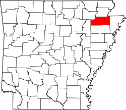
Bowman is an unincorporated community and census-designated place (CDP) in Craighead County, Arkansas, United States. [1] It was first listed as a CDP in the 2020 census with a population of 75. [2]
Census | Pop. | Note | %± |
---|---|---|---|
2020 | 75 | — | |
U.S. Decennial Census [3] 2020 [4] |
Race / Ethnicity (NH = Non-Hispanic) | Pop 2020 [4] | % 2020 |
---|---|---|
White alone (NH) | 67 | 89.33% |
Black or African American alone (NH) | 0 | 0.00% |
Native American or Alaska Native alone (NH) | 0 | 0.00% |
Asian alone (NH) | 0 | 0.00% |
Pacific Islander alone (NH) | 0 | 0.00% |
Some Other Race alone (NH) | 0 | 0.00% |
Mixed Race or Multi-Racial (NH) | 2 | 2.67% |
Hispanic or Latino (any race) | 6 | 8.00% |
Total | 75 | 100.00% |
At 3:08 p.m. CDT on April 27, 2011, a tornado hit Bowman as part of the 2011 Super Outbreak. [5] The tornado was rated EF1 with winds at 90 mph (140 km/h), a width of 250 yards (230 m), that traveled a path of 1.6 miles (2.6 km). [5] The tornado caused roof damage to five homes and a business garage, and destroyed a storage shed. [5]
McDonald Chapel is a census-designated place in Jefferson County, Alabama, United States. It is northeast of the Birmingham suburb of Pleasant Grove. At the 2020 census, the population was 739. Large portions of this area were damaged by violent tornadoes in 1956, 1998, and 2011. The 1998 tornado was rated F5 on the Fujita scale.
Prairie Creek is a census-designated place (CDP) in Benton County, Arkansas, United States. Per the 2020 census, the population was 2,217. It is a lakefront community adjacent to Beaver Lake and Rogers within the Northwest Arkansas region.
Kendall West is a census-designated place and unincorporated community in Miami-Dade County, Florida, west of the Florida Turnpike. It is located in the Miami metropolitan area of South Florida. The population was 36,536 at the 2020 census.
Experiment is an unincorporated community and census-designated place (CDP) in Spalding County, Georgia, United States. The population was 3,233 at the 2000 census.
Lula is a town in Coahoma County, Mississippi, United States. Per the 2020 census, the population was 204.
Campbelltown is an unincorporated community and census-designated place (CDP) in Lebanon County, Pennsylvania, United States. The population was 3,616 at the 2010 census. It is located east of Hershey at the intersection of U.S. Route 322 and Pennsylvania Route 117 and is located in the Harrisburg metropolitan area.
Laguna Heights is a census-designated place (CDP) in Cameron County, Texas, United States. The population was 3,488 at the 2010 census.
Convent is a census-designated place in and the parish seat of St. James Parish, Louisiana, United States. It has been the parish seat since 1869. It is part of the New Orleans metropolitan area.
New Blaine is an unincorporated community and census-designated place (CDP) in Logan County, Arkansas, United States. Per the 2020 census, the population was 173.
Bee Branch is an unincorporated community and census-designated place (CDP) in Van Buren County, Arkansas, United States. It was first listed as a CDP in the 2020 census with a population of 293.
Lawrence is an unincorporated community and census-designated place in Chemung Township, McHenry County, Illinois, United States. Lawrence is 2 miles (3.2 km) northwest of Harvard. It was named a CDP before the 2020 census, at which time it had a population of 220.
Uniontown is an unincorporated community and census-designated place (CDP) in Crawford County, Arkansas, United States. It is located on Arkansas Highway 220 near the Oklahoma border, 4.5 miles (7.2 km) west-northwest of Cedarville. Uniontown has a post office with ZIP code 72955.
Cincinnati is an unincorporated community and census-designated place (CDP) in northwestern Washington County, Arkansas, United States. It was first listed as a CDP in the 2020 census with a population of 306.
Pearcy is an unincorporated community and census-designated place (CDP) in Garland County, Arkansas, United States. It was first listed as a CDP in the 2020 census with a population of 306.
Crystal Springs is an unincorporated community and census-designated place (CDP) in Garland County, Arkansas, United States. It was first listed as a CDP in the 2020 census with a population of 129.
Yarborough Landing is a census-designated place in Little River County, Arkansas, United States. Per the 2020 census, the population was 457.
Centerville is an unincorporated community and census-designated place (CDP) in Yell County, Arkansas, United States. Centerville is located at the junction of Arkansas Highways 7 and 154, 6.5 miles (10.5 km) north-northeast of Ola. It was first listed as a CDP in the 2020 census with a population of 283.
Mount Olive is an unincorporated community and census-designated place (CDP) in Izard County, Arkansas, United States. Mount Olive is located on the White River, 11.1 miles (17.9 km) west-southwest of Melbourne.
Halley is an unincorporated community and census-designated place (CDP) in Desha County, Arkansas, United States. It was first listed as a CDP in the 2020 census with a population of 44.
Collins is an unincorporated community and census-designated place (CDP) in Drew County, Arkansas, United States. It is located along Arkansas Highway 35, 7 miles (11 km) west of Dermott and 15 miles (24 km) southeast of Monticello. It was first listed as a CDP in the 2020 census with a population of 149.