
Northumberland is a ceremonial county in North East England, bordering Scotland. It is bordered by the Scottish Borders to the north, the North Sea to the east, Tyne and Wear and County Durham to the south, and Cumbria to the west. The town of Blyth is the largest settlement.

Corbridge is a village in Northumberland, England, 16 miles (26 km) west of Newcastle and 4 miles (6 km) east of Hexham. Villages nearby include Halton, Acomb, Aydon and Sandhoe.

Hexham is a market town and civil parish in Northumberland, England, on the south bank of the River Tyne, formed by the confluence of the North Tyne and the South Tyne at Warden nearby, and close to Hadrian's Wall. Hexham was the administrative centre for the Tynedale district from 1974 to 2009. In 2011, it had a population of 13,097.

The Tyne Bridge is a through arch bridge over the River Tyne in North East England, linking Newcastle upon Tyne and Gateshead. The bridge was designed by the engineering firm Mott, Hay and Anderson, who later designed the Forth Road Bridge, and was built by Dorman Long and Co. of Middlesbrough. The bridge was officially opened on 10 October 1928 by King George V and has since become a defining symbol of Tyneside. It is ranked as the tenth tallest structure in Newcastle.

Newcastle station is a railway station in Newcastle, Tyne and Wear, England, United Kingdom. It is located on the East Coast Main Line, around 268 miles (432 km) north of London King's Cross. It is the primary national rail station serving Newcastle upon Tyne and is an interchange for local services provided by the Tyne and Wear Metro network whose Central Station is situated beneath the national rail station. It is the busiest station in Tyne & Wear, as well as the busiest in North East England.

Haydon Bridge is a village in Northumberland, England, which had a population of 2,184 in the 2011 census. Its most distinctive features are the two bridges crossing the River South Tyne: the picturesque original bridge after which the village was named and a modern bridge which used to carry the A69 road. A bypass was completed in 2009 and the A69 now bypasses the village to the south.

Bellingham is a village and civil parish in Northumberland, to the north-west of Newcastle upon Tyne and is situated on the Hareshaw Burn at its confluence with the River North Tyne. In 2011 the parish had a population of 1334.

Wylam is a village and civil parish in the county of Northumberland, England. It is located about 10 miles (16 km) west of Newcastle upon Tyne.

Berwick Bridge, also known as the Old Bridge, spans the River Tweed in Berwick-upon-Tweed, Northumberland, England. The current structure is a Grade I listed stone bridge built between 1611 and 1624.

Coldstream Bridge, linking Coldstream, Scottish Borders with Cornhill-on-Tweed, Northumberland, is an 18th-century Category A/Grade II* listed bridge between England and Scotland, across the River Tweed. The bridge carries the A697 road across the Tweed.

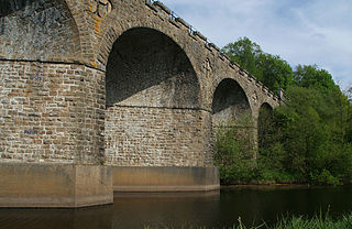
The Royal Border Bridge spans the River Tweed between Berwick-upon-Tweed and Tweedmouth in Northumberland, England. It is a Grade I listed railway viaduct built between 1847 and 1850, when it was opened by Queen Victoria. It was designed by Robert Stephenson. It was built for the York, Newcastle and Berwick Railway and is still in regular use today, as part of the East Coast Main Line. Despite its name, the bridge does not in fact span the border between England and Scotland, which is approximately three miles further north.
Ovingham is a village and civil parish in the Tyne Valley of south Northumberland, England. It lies on the River Tyne 10 miles (16 km) east of Hexham with neighbours Prudhoe, Ovington, Wylam and Stocksfield.

Riding Mill is a village near Hexham in Northumberland, England. It is part of the civil parish of Broomhaugh and Riding. It is served by Riding Mill railway station and by a frequent bus service on the route from Hexham to Newcastle.

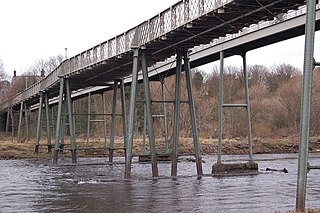
Wylam Railway Bridge is a footbridge and former railway bridge crossing the River Tyne at Hagg Bank, approximately 1⁄2 mile (0.8 km) west of Wylam in Northumberland, England.
John Green and Benjamin Green were a father and son who worked in partnership as architects in North East England during the early nineteenth century. John, the father was a civil engineer as well as an architect. Although they did carry out some commissions separately, they were given joint credit for many of their projects, and it is difficult to attribute much of their work to a single individual. In general, John Green worked on civil engineering projects, such as road and rail bridges, whereas Benjamin worked on projects that were more purely architectural. Their work was predominantly church and railway architecture, with a sprinkling of public buildings that includes their masterpiece, Newcastle's Theatre Royal.
Warden is a village in Northumberland, England about 2 miles (3 km) west of Hexham.
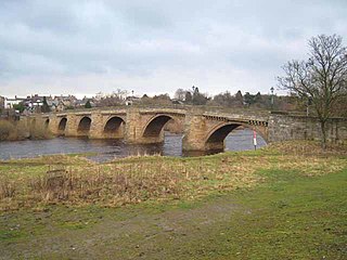
Corbridge Bridge is a 17th-century stone bridge across the River Tyne at Corbridge, Northumberland, England.

Hexham Old Bridge was an 18th-century stone bridge across the River Tyne at Hexham, Northumberland, England. It was located about 1 mile (2 km) upstream of the present Hexham Bridge.

The Tyne Valley Line is a 58-mile (93 km) route, linking Newcastle upon Tyne with Hexham and Carlisle, England. The line follows the course of the River Tyne through Tyne and Wear and Northumberland. Five stations and two viaducts on the route are listed structures.
Kielder Viaduct consists of seven semi-circular masonry skew arches and was built in 1862 by the North British Railway to carry the Border Counties Line across marshy land, which following flooding to create Kielder Water, became the place where Deadwater Burn joins Bakethin Reservoir. Now closed to rail traffic, the bridge is currently used as a footpath.

