Higashikagawa (東かがわ市, Higashikagawa-shi) is a city located in Kagawa Prefecture, Japan. As of 30 September 2022 [update] , the city had an estimated population of 28,627 in 13689 households and a population density of and a population density of 970 persons per km2. [2] The total area of the city is 152.83 square kilometres (59.01 sq mi).
Higashikagawa is located in far eastern Kagawa Prefecture, on the island of Shikoku, facing the Seto Inland Sea to the north. The south borders Tokushima Prefecture through the Sanuki Mountains, which stretch from east to west. The city is located roughly halfway between Takamatsu City and Tokushima City.
Kagawa Prefecture
Tokushima Prefecture
Higashikagawa has a humid subtropical climate (Köppen climate classification Cfa) with hot, humid summers, and cool winters. Some rain falls throughout the year, but the months from May to September have the heaviest rain. The average annual temperature in Higashikagawa is 15.9 °C (60.6 °F). The average annual rainfall is 1,343.6 mm (52.90 in) with September as the wettest month. The temperatures are highest on average in August, at around 27.2 °C (81.0 °F), and lowest in January, at around 5.5 °C (41.9 °F). [3] The highest temperature ever recorded in Higashikagawa was 37.0 °C (98.6 °F) on 13 August 1984; the coldest temperature ever recorded was −6.7 °C (19.9 °F) on 7 February 2018. [4]
Climate data for Hiketa, Higashikagawa (1991−2020 normals, extremes 1978−present) | |||||||||||||
---|---|---|---|---|---|---|---|---|---|---|---|---|---|
Month | Jan | Feb | Mar | Apr | May | Jun | Jul | Aug | Sep | Oct | Nov | Dec | Year |
Record high °C (°F) | 18.4 (65.1) | 24.2 (75.6) | 25.7 (78.3) | 30.9 (87.6) | 31.3 (88.3) | 35.1 (95.2) | 37.0 (98.6) | 37.0 (98.6) | 36.8 (98.2) | 31.5 (88.7) | 26.1 (79.0) | 23.0 (73.4) | 37.0 (98.6) |
Mean daily maximum °C (°F) | 9.2 (48.6) | 9.8 (49.6) | 13.1 (55.6) | 18.8 (65.8) | 23.7 (74.7) | 26.4 (79.5) | 30.4 (86.7) | 31.7 (89.1) | 27.8 (82.0) | 22.4 (72.3) | 17.0 (62.6) | 11.8 (53.2) | 20.2 (68.3) |
Daily mean °C (°F) | 5.5 (41.9) | 5.7 (42.3) | 8.6 (47.5) | 13.7 (56.7) | 18.6 (65.5) | 22.2 (72.0) | 26.1 (79.0) | 27.2 (81.0) | 23.8 (74.8) | 18.5 (65.3) | 13.1 (55.6) | 7.9 (46.2) | 15.9 (60.7) |
Mean daily minimum °C (°F) | 1.8 (35.2) | 1.8 (35.2) | 4.2 (39.6) | 8.9 (48.0) | 14.1 (57.4) | 18.7 (65.7) | 22.9 (73.2) | 23.8 (74.8) | 20.6 (69.1) | 15.1 (59.2) | 9.3 (48.7) | 4.3 (39.7) | 12.1 (53.8) |
Record low °C (°F) | −5.3 (22.5) | −6.7 (19.9) | −4.5 (23.9) | −0.8 (30.6) | 4.4 (39.9) | 10.1 (50.2) | 16.6 (61.9) | 17.2 (63.0) | 10.6 (51.1) | 4.3 (39.7) | 1.6 (34.9) | −3.0 (26.6) | −6.7 (19.9) |
Average precipitation mm (inches) | 36.3 (1.43) | 44.1 (1.74) | 72.9 (2.87) | 78.6 (3.09) | 111.3 (4.38) | 159.3 (6.27) | 159.4 (6.28) | 168.6 (6.64) | 244.0 (9.61) | 149.0 (5.87) | 62.0 (2.44) | 46.2 (1.82) | 1,343.6 (52.90) |
Average precipitation days (≥ 1.0 mm) | 6.6 | 6.8 | 9.8 | 9.6 | 8.8 | 11.3 | 10.1 | 8.6 | 10.5 | 8.9 | 6.9 | 6.6 | 104.5 |
Mean monthly sunshine hours | 147.6 | 140.3 | 176.7 | 202.5 | 207.3 | 154.2 | 194.6 | 227.1 | 156.6 | 154.3 | 137.5 | 137.6 | 2,039.1 |
Source: Japan Meteorological Agency [4] [3] |
Per Japanese census data, the population of Higashikagawa in 2020 is 28,279 people. [5] Higashikagawa has been conducting censuses since 1920.
Year | Pop. | ±% |
---|---|---|
1920 | 32,161 | — |
1925 | 32,137 | −0.1% |
1930 | 33,909 | +5.5% |
1935 | 34,830 | +2.7% |
1940 | 34,326 | −1.4% |
1945 | 46,248 | +34.7% |
1950 | 45,831 | −0.9% |
1955 | 44,662 | −2.6% |
1960 | 44,428 | −0.5% |
1965 | 44,577 | +0.3% |
1970 | 42,572 | −4.5% |
1975 | 43,049 | +1.1% |
1980 | 43,110 | +0.1% |
1985 | 42,446 | −1.5% |
1990 | 40,875 | −3.7% |
1995 | 39,226 | −4.0% |
2000 | 37,760 | −3.7% |
2005 | 35,929 | −4.8% |
2010 | 33,646 | −6.4% |
2015 | 31,031 | −7.8% |
2020 | 28,279 | −8.9% |
Higashikagawa population statistics [5] |
The area of Higashikagawa was part of ancient Sanuki Province. From the Heian period the Hiketa port prospered as a good natural harbor and a gateway to Shikoku from the Kinai region. From the Sengoku period, Hiketa Castle was a stronghold of the Ikoma clan and a castle town developed around the fortifications. Even today, many of the intricate alleyways and old buildings from the Edo and Meiji periods still exist, preserving the atmosphere of a pre-modern fishing town. During the Edo Period, this area was part of the holdings of Takamatsu Domain. Following the Meiji restoration, the area was organized into villages within Ōchi District, Kagawa with the creation of the modern municipalities system on February 15, 1890. Hiketa was elevated to town status on October 1, 1909. The city of Higashikagawa was the result of a merger on April 1, 2003 between Hiketa and the towns of Ōchi and Shirotori, both from Ōkawa District (which was dissolved as a result of the merger). [6]
Higashikagawa has a mayor-council form of government with a directly elected mayor and a unicameral city council of 18 members. Higashikagawa contributes two members to the Kagawa Prefectural Assembly. In terms of national politics, the city is within the Kagawa 2nd district of the lower house of the Diet of Japan.
Higashikagawa has a mixed economy centered on light manufacturing, commercial fishing and agriculture. [7] Traditionally, the city was noted for its production of gloves, claiming a 90% market share; [8] however, due to labor costs, much of the market has been lost to China and southeast Asia. Another prominent industry is the manufacturing of bearings. JTEKT (formerly Koyo Seiko), one of the major companies of the Toyota Group, produces 25% of the global market share of tapered roller bearings. The former town of Hiketa is a center for producing wasanbon , a fine-grained sugar traditional to the region. [9] In terms of fishing, Yellowtail was first successfully farmed here. [10]
Higashikagawa has two public elementary schools and two public middle schools operated by the city government, and one public high schools operated by the Kagawa Prefectural Board of Education.
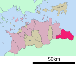
Kagawa Prefecture is a prefecture of Japan located on the island of Shikoku. Kagawa Prefecture has a population of 949,358 and is the smallest prefecture by geographic area at 1,877 square kilometres (725 sq mi). Kagawa Prefecture borders Ehime Prefecture to the southwest and Tokushima Prefecture to the south.
Anan is a city in Tokushima Prefecture, Japan. As of 30 June 2022, the city had an estimated population of 70,285 in 31313 households and a population density of 250 persons per km². The total area of the city is 279.25 square kilometres (107.82 sq mi).
Sanuki is a city in Kagawa Prefecture, Japan. As of 1 September 2022, the city had an estimated population of 46,016 in 20847 households and a population density of and a population density of 290 persons per km2. The total area of the city is 158.63 square kilometres (61.25 sq mi).
Miki is a town located in Kagawa Prefecture, Japan. As of 1 September 2022, the town had an estimated population of 26,449 in 10963 households and a population density of 270 persons per km2. The total area of the town is 75.78 square kilometres (29.26 sq mi).
Tadotsu is a town located in Nakatado District, Kagawa Prefecture, Japan. As of 1 October 2022, the town had an estimated population of 22,124 in 10365 households and a population density of 270 persons per km2. The total area of the town is 24.39 square kilometres (9.42 sq mi).
Itano is a town located in Itano District, Tokushima Prefecture, Japan. As of 30 June 2022, the town had an estimated population of 13,105 in 5790 households and a population density of 360 persons per km². The total area of the town is 36.22 square kilometres (13.98 sq mi).
Mima is a city located in Tokushima Prefecture, Japan. As of 1 February 2022, the city had an estimated population of 27,713 in 12,547 households and a population density of 75 persons per km2. The total area of the city is 367.14 square kilometres (141.75 sq mi).
Shikokuchūō is a city located in Ehime Prefecture, Japan. As of August 31, 2022, the city had an estimated population of 83,635 in 28876 households and a population density of 200 persons per km². The total area of the city is 421.24 square kilometres (162.64 sq mi). Shikokuchūō is the leading producer of paper and paper products in Japan. It is also a port city and one of Ehime's major centers of industry.
Miyoshi is a city located in Tokushima Prefecture, Japan. As of 30 June 2022, the city had an estimated population of 23,782 in 12103 households and a population density of 33 persons per km2. The total area of the city is 721.42 square kilometres (278.54 sq mi).
Mitoyo is a city located in Kagawa Prefecture, Japan. As of 31 September 2022, the city had an estimated population of 59,876 in 23024 households and a population density of 270 persons per km2. The total area of the city is 222.73 square kilometres (86.00 sq mi).
Ayagawa is a town located in Ayauta District, Kagawa Prefecture, Japan. As of 1 October 2022, the town had an estimated population of 23,427 in 10108 households and a population density of 960 persons per km2. The total area of the town is 109.75 square kilometres (42.37 sq mi).
The Kōtoku Line is a railway line in northeastern Shikoku, Japan that connects the prefectural capitals Takamatsu (Kagawa) and Tokushima (Tokushima). Shikoku Railway Company owns and operates the line, whose name comes from the characters in the cities that the line connects: Takamatsu (高松) and Tokushima (徳島).
Takamatsu is a capital city located in Kagawa Prefecture, Japan. As of 1 November 2022, the city had an estimated population of 414,134 in 190,120 households and a population density of 1,100 persons per km2. The total area of the city is 375.41 square kilometres (144.95 sq mi). It is the capital city of the prefecture.
Kaiyō is a town located in Kaifu District, Tokushima Prefecture, Japan. As of 1 May 2022, the town had an estimated population of 8,699 in 4488 households and a population density of 27 persons per km². The total area of the town is 327.65 square kilometres (126.51 sq mi).
Ōkawa was a former district in Kagawa Prefecture, Japan. It included several towns in the eastern part of the prefecture.
Sanuki-Aioi Station is a passenger railway station located in the city of Higashikagawa, Kagawa Prefecture, Japan. It is operated by JR Shikoku and has the station number "T09".
Hiketa Station is a passenger railway station located in the city of Higashikagawa, Kagawa Prefecture, Japan. It is operated by JR Shikoku and has the station number "T10".
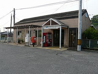
Sanuki-Shirotori Station is a passenger railway station located in the city of Higashikagawa, Kagawa Prefecture, Japan. It is operated by JR Shikoku and has the station number "T11".
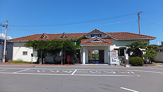
Sambommatsu Station is a passenger railway station located in the city of Higashikagawa, Kagawa Prefecture, Japan. It is operated by JR Shikoku and has the station number "T12".
Hiketa Castle was a Sengoku period Japanese castle located in what is now part of the city of Higashikagawa, Kagawa Prefecture, Japan. Its ruins have been protected by the central government as a National Historic Site since 2020.