Related Research Articles

The Moine Thrust Belt or Moine Thrust Zone is a linear tectonic feature in the Scottish Highlands which runs from Loch Eriboll on the north coast 190 kilometres (120 mi) south-west to the Sleat peninsula on the Isle of Skye. The thrust belt consists of a series of thrust faults that branch off the Moine Thrust itself. Topographically, the belt marks a change from rugged, terraced mountains with steep sides sculptured from weathered igneous, sedimentary and metamorphic rocks in the west to an extensive landscape of rolling hills over a metamorphic rock base to the east. Mountains within the belt display complexly folded and faulted layers and the width of the main part of the zone varies up to 10 kilometres (6.2 mi), although it is significantly wider on Skye.

The Highland Boundary Fault is a major fault zone that traverses Scotland from Arran and Helensburgh on the west coast to Stonehaven in the east. It separates two different geological terranes which give rise to two distinct physiographic terrains: the Highlands and the Lowlands, and in most places it is recognisable as a change in topography. Where rivers cross the fault, they often pass through gorges, and the associated waterfalls can be a barrier to salmon migration.

The Caledonian orogeny was a mountain-building cycle recorded in the northern parts of the British Isles, the Scandinavian Caledonides, Svalbard, eastern Greenland and parts of north-central Europe. The Caledonian orogeny encompasses events that occurred from the Ordovician to Early Devonian, roughly 490–390 million years ago (Ma). It was caused by the closure of the Iapetus Ocean when the Laurentia and Baltica continents and the Avalonia microcontinent collided.
The Dalradian Supergroup is a stratigraphic unit in the lithostratigraphy of the Grampian Highlands of Scotland and in the north and west of Ireland. The diverse assemblage of rocks which constitute the supergroup extend across Scotland from Islay in the west to Fraserburgh in the east and are confined by the Great Glen Fault to the northwest and the Highland Boundary Fault to the southeast. Much of Shetland east of the Walls Boundary Fault is also formed from Dalradian rocks. Dalradian rocks extend across the north of Ireland from County Antrim in the north east to Clifden on the Atlantic coast, although obscured by later Palaeogene lavas and tuffs or Carboniferous rocks in large sections.

The Lizard complex, Cornwall is generally accepted to represent a preserved example of an exposed ophiolite complex in the United Kingdom. The rocks found in The Lizard area are analogous to those found in such famous areas as the Troodos Mountains, Cyprus and the Semail Ophiolite, Oman.

The Nordfjord—Sogn Detachment (NSD) is a major extensional shear zone in Norway up to 6 km in thickness, which extends about 120 km along strike from Nordfjord to Sognefjord, bringing Devonian continental coarse clastic sedimentary rocks into close contact with eclogite facies metamorphic rocks of the Western Gneiss Region. It formed towards the end of the Caledonian Orogeny and was mainly active during the Devonian. It has an estimated displacement of at least 70 km and possibly as much as 110 km. It was reactivated during the Mesozoic and may have influenced the development of fault structures in the North Sea rift basin.
The Scandinavian Caledonides are the vestiges of an ancient, today deeply eroded orogenic belt formed during the Silurian–Devonian continental collision of Baltica and Laurentia, which is referred to as the Scandian phase of the Caledonian orogeny. The size of the Scandinavian Caledonides at the time of their formation can be compared with the size of the Himalayas. The area east of the Scandinavian Caledonides, including parts of Finland, developed into a foreland basin where old rocks and surfaces were covered by sediments. Today, the Scandinavian Caledonides underlay most of the western and northern Scandinavian Peninsula, whereas other parts of the Caledonides can be traced into West and Central Europe as well as parts of Greenland and eastern North America.
This article describes the geology of the Cairngorms National Park, an area in the Highlands of Scotland designated as a national park in 2003 and extended in 2010. The Cairngorms National Park extends across a much wider area than the Cairngorms massif itself and hence displays rather more varied geology.
The geology of Mozambique is primarily extremely old Precambrian metamorphic and igneous crystalline basement rock, formed in the Archean and Proterozoic, in some cases more than two billion years ago. Mozambique contains greenstone belts and spans the Zimbabwe Craton, a section of ancient stable crust. The region was impacted by major tectonic events, such as the mountain building Irumide orogeny, Pan-African orogeny and the Snowball Earth glaciation. Large basins that formed in the last half-billion years have filled with extensive continental and marine sedimentary rocks, including rocks of the extensive Karoo Supergroup which exist across Southern Africa. In some cases these units are capped by volcanic rocks. As a result of its complex and ancient geology, Mozambique has deposits of iron, coal, gold, mineral sands, bauxite, copper and other natural resources.

The geology of Sweden is the regional study of rocks, minerals, tectonics, natural resources and groundwater in the country. The oldest rocks in Sweden date to more than 2.5 billion years ago in the Precambrian. Complex orogeny mountain building events and other tectonic occurrences built up extensive metamorphic crystalline basement rock that often contains valuable metal deposits throughout much of the country. Metamorphism continued into the Paleozoic after the Snowball Earth glaciation as the continent Baltica collided with an island arc and then the continent Laurentia. Sedimentary rocks are most common in southern Sweden with thick sequences from the last 250 million years underlying Malmö and older marine sedimentary rocks forming the surface of Gotland.
The geology of Iraq includes thick sequences of marine and continental sedimentary rocks over poorly understood basement rock, at the junction of the Arabian Plate, the Anatolian Plate, and the Iranian Plate.
The geology of national parks in Britain strongly influences the landscape character of each of the fifteen such areas which have been designated. There are ten national parks in England, three in Wales and two in Scotland. Ten of these were established in England and Wales in the 1950s under the provisions of the National Parks and Access to the Countryside Act 1949. With one exception, all of these first ten, together with the two Scottish parks were centred on upland or coastal areas formed from Palaeozoic rocks. The exception is the North York Moors National Park which is formed from sedimentary rocks of Jurassic age.
The geology of Loch Lomond and The Trossachs National Park in the southwestern part of the Scottish Highlands consists largely of Neoproterozoic and Palaeozoic bedrock faulted and folded and subjected to low grade metamorphism during the Caledonian orogeny. These older rocks, assigned to the Dalradian Supergroup, lie to the northwest of the northeast – southwest aligned Highland Boundary Fault which defines the southern edge of the Highlands. A part of this mountainous park extends south of this major geological divide into an area characterised by younger Devonian rocks which are assigned to the Old Red Sandstone.
The Grampian orogeny was an orogeny that affected Scotland in the middle of the Ordovician. At the time, Scotland was part of proto-North American continent Laurentia.

The Hornelen Basin is a sedimentary basin in Vestland, Norway, containing an estimated 25 km stratigraphic thickness of coarse clastic sedimentary rocks of Devonian age. It forms part of a group of basins of similar age along the west coast of Norway between Sognefjord and Nordfjord, related to movement on the Nordfjord-Sogn Detachment. It formed as a result of extensional tectonics as part of the post-orogenic collapse of crust that was thickened during the Caledonian Orogeny towards the end of the Silurian period. It is named for the mountain Hornelen on the northern margin of the basin.
The Ballantrae Complex is an assemblage of rocks in southwest Scotland considered to be an ophiolite, that is a section of the earth's oceanic crust and upper mantle obducted onto continental crust. The complex is bounded by the coast of the Firth of Clyde to the west and the Stinchar Valley Fault, a constituent element of the Southern Uplands Fault to the south. The emplacement of this highly faulted assemblage of both intrusive and extrusive igneous rocks and metamorphic rocks took place within the Grampian phase of the Caledonian orogeny.

The Loch Ness Supergroup is one of the subdivisions of the Neoproterozoic sequence of sedimentary rocks in the Scottish Highlands. It is found everywhere in tectonic contact above the older Wester Ross Supergroup. It is thought to be unconformably overlain by the Cryogenian to Cambrian Dalradian Supergroup.
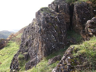
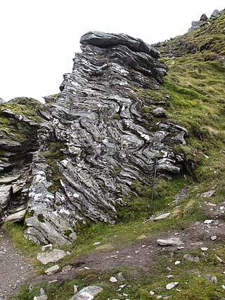
The Highland Border Complex is an assemblage of rocks of probable early Cambrian to late Ordovician age, found as fault-bounded blocks of variable lithology exposed immediately to the southeast of the Highland Boundary Fault at the edge of the Grampian Highlands, Scotland.
The Sgurr Beag Thrust is an important tectonic structure within the Neoproterozoic metasedimentary rock sequences of the Scottish Highlands. The thrust, or similar structures correlated with it, form the boundary between rocks of the Glennfinnan Group and the underlying Morar Group. It divides the Wester Ross Supergroup from the Loch Ness Supergroup. The history of this structure remains poorly understood although it is thought to be at least partly of Caledonian age.
The Moinian or just the Moine, formerly the Moine Supergroup, is a sequence of Neoproterozoic metasediments that outcrop in the Northwest Highlands between the Moine Thrust Belt to the northwest and the Great Glen Fault to the southeast and one part of the Grampian Highlands to the southeast of the fault. It takes its name from A' Mhòine, a peat bog in northern Sutherland.
References
- 1 2 3 Tanner, P.W.; Sutherland, S. (2007). "The Highland Border Complex, Scotland: a paradox resolved". Journal of the Geological Society. 164 (1): 111–116. doi:10.1144/0016-76492005-188.
- 1 2 Bluck, B.J. (2010). "The Highland Boundary Fault and the Highland Border Complex". Scottish Journal of Geology. 46 (2): 113–124. doi:10.1144/0036-9276/01-411.
- 1 2 Leslie, G. (3 March 2009). "Border skirmish" (PDF). Geoscientist Online. Geological Society of London. Retrieved 21 June 2024.
- ↑ British Geological Survey. "Trossachs Group". BGS Lexicon of Named Rock Units. Retrieved 21 June 2024.
- ↑ Chew, D.M.; Strachan, R.A. (2014). "The Laurentian Caledonides of Scotland and Ireland". In Corfu, F.; Gasser, D.; Chew, D.M. (eds.). New Perspectives on the Caledonides of Scandinavia. Special Publications. Vol. 390. Geological Society of London. pp. 45–91. doi:10.1144/SP390.16.