This article describes the transport in Peru.

Lima, founded in 1535 as the Ciudad de los Reyes, is the capital and largest city of Peru. It is located in the valleys of the Chillón, Rímac and Lurín Rivers, in the desert zone of the central coastal part of the country, overlooking the Pacific Ocean. The city is considered the political, cultural, financial and commercial center of Peru. Due to its geostrategic importance, the Globalization and World Cities Research Network has categorized it as a "beta" tier city. Jurisdictionally, the metropolis extends mainly within the province of Lima and in a smaller portion, to the west, within the Constitutional Province of Callao, where the seaport and the Jorge Chávez Airport are located. Both provinces have regional autonomy since 2002.

Ancash is a department and region in western Peru. It is bordered by the departments of La Libertad on the north, Huánuco and Pasco on the east, Lima on the south, and the Pacific Ocean on the west. Its capital is the city of Huaraz, and its largest city and port is Chimbote. The name of the region originates from the Quechua word anqash, from anqas ('blue') or from anka ('eagle').

The Pan-American Highway is a network of roads stretching across the Americas, measuring about 30,000 kilometres (19,000 mi) in total length. Except for a break of about 100 km (60 mi) across the border between Colombia and Panama, the roads link most of the Pacific coastal countries of North America and South America in a connected highway system. According to Guinness World Records, the Pan-American Highway is the world's longest "motorable road".

David, known as David City in colonial times, is a city and corregimiento in the west of Panama. It is the capital of the province of Chiriquí and has an estimated population of 82,907 inhabitants as confirmed in 2013. It is a relatively affluent city with a firmly established, dominant middle class and a very low unemployment and poverty index. The Pan-American Highway is a popular route to David. It is named after the Biblical King David. David is the largest city in Panama that is not part of the Panama city metro area.

Lima is a district of Lima Province in Peru. Lima district is the oldest in Lima Province and as such, vestiges of the city's colonial era remain today in the historic centre of Lima, which was declared a UNESCO World Heritage Site in 1988 and contains the foundational area known as Cercado de Lima.
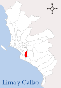
The Lima Metropolitan Area is an area formed by the conurbation of the Peruvian provinces of Lima and Callao. It is the largest of the metropolitan areas of Peru, the seventh largest in the Americas, the fourth largest in Latin America, and among the thirty largest in the world. The conurbation process started to be evident in the 1980s.

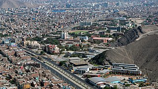
San Martín de Porres (SMP) is a district in Lima, Peru, located in the north area of the city. It is bordered by the Chillón River, marks its natural border with Ventanilla and Puente Piedra on the north; Callao on the west; Los Olivos, Comas on the northeast; Rímac and Independencia districts on the east; the Rímac River marks its natural border with Lima District and Carmen de la Legua Reynoso on the south. It is the second most populated district of Lima metropolitan area and Peru.

Chaclacayo is a district of the Lima Province in Peru. Together with Chosica, Chaclacayo is the natural exit district to Central Peru, east of Lima, through the Carretera Central.
The district of San Juan de Miraflores is one of the forty-three districts that make up the province of Lima, located in the department of the same name, in Peru. Is one of the new towns, that have been formed by the massive numbers of people moving from other towns of Metropolitan Lima and from the countryside. During the early 1960s, was mostly a desert area.
The primary highways of Peru are assigned using a numeric designation and sometimes a name. Spur and loop routes are designated with the parent highway's number and a letter.

Colombian geography presents formidable challenges to roadbuilders, who need to integrate its largest production centers deep within the Andes with major ports in both the Atlantic and Pacific oceans. All of this creates a heavy premium to roadbuilding, compared with the cost of building highways in flat terrain. Therefore, the Colombian government is undertaking a great effort in order to improve the highway system, under the name of Fourth Generation Highways, with the intent of updating major roads to international safety and speed standards. This project will be funded through both public and private capital, with a total worth of nearly US$23 billion, accounting to a yearly investment of 3% of national GDP, improving or building a grand total of over 8.000 km of roads. These roads are expected to improve Colombia's competitiveness in order to successfully take advantage of the many trade agreements signed in recent years.
Ciudad Cuauhtémoc is a town in the extreme southern Mexican state of Chiapas. It is part of the municipality of Frontera Comalapa and is situated on the Guatemala-Mexico border opposite the city of La Mesilla, Huehuetenango, Guatemala. As of 2010, Ciudad Cuauhtémoc had a population of 2,325.
The 2015 Pan-American Volleyball Cup was the fourteenth edition of the annual women's volleyball tournament, played by twelve countries over June, 2014 in Lima and Callao, Peru. The competition served as a qualifier for the 2016 FIVB World Grand Prix. The United States won their fourth championship defeating 3–0 to the Dominican Republic and the American Krista Vansant won the Most Valuable Player of the tournament.

Juan Ramón Rivero Torres, was a Bolivian engineer and businessman responsible for the development of several cross-border infrastructure projects that improved regional integration in South America during the first half of the 20th century. The completion of the railroad connecting Santa Cruz, Bolivia to Corumbá, Brazil effectively linked South America's Atlantic and Pacific coasts.

The Carretera Central of Peru or National Route 22 is a two-lane highway that crosses through Central Peru. It begins in the city of Lima, and connects with the department of Junin in Central Peru. An update to the highway with an expansion to four lanes was announced in 2020 and is expected to be completed by 2025.

From December 2016 and continuing until May 2017, much of western and central South America was plagued by persistent heavy rain events. In Peru, one of the most severely impacted nations, it has been referred to as the 2017 Coastal Niño. The flooding was preceded by drought-like conditions throughout the region for much of 2016 and a strong warming of sea temperatures off the coast of Peru.

National Route 1 (N1) is a primary national route that forms part of the Philippine highway network, running from Luzon to Mindanao. Except for a 19-kilometer (12 mi) gap in Metro Manila and ferry connections, the highway is generally continuous. Most sections of N1 forms the Pan-Philippine Highway except for sections bypassed by expressways.
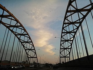
The Army Bridge is a tied-arch bridge that crosses Rímac River in the limits of Rímac and San Martín de Porres districts of Lima, Peru. It joins Alfonso Ugarte Avenue to the south with Caquetá Avenue to the north. It was inaugurated on December 31, 1936, under then president Óscar R. Benavides, and was later remodelled in the 1950s, under the presidency of Manuel A. Odría.
Túpac Amaru Avenue, also known as the Highway to Ancón and as the Former Northern Pan-American Highway until 1974, is a major avenue in Lima, Peru. It starts at Caquetá Avenue in Rímac District, travelling northbound for over 40 blocks while crossing San Martín de Porres, Los Olivos, Independencia and Comas districts, until it reaches Trapiche, becoming the Vencedores de Sángrar Highway in Carabayllo District, which connects Lima with Canta.

