The Lahaul and Spiti district in the Indian state of Himachal Pradesh consists of the two formerly separate districts of Lahaul and Spiti. The present administrative center is Kyelang in Lahaul. Before the two districts were merged, Kardang was the capital of Lahaul, and Dhankar the capital of Spiti. The district was formed in 1960 and is the fourth least populous district in India. It is the least densely populated district of India, according to the Census of India 2011.

Kyelang is a town and the administrative centre of the Lahaul and Spiti district in the Indian state of Himachal Pradesh, 71 kilometres (44 mi) north of Manali via Atal Tunnel and 120 km (75 mi) from the Indo-Tibetan border. It is located along the Manali-Leh Highway, about 7 km northeast of intersection of the Chandra, Bhaga, and Chenab valleys, on the banks of Bhaga River.

Tabo is a small town in the Lahaul and Spiti district on the banks of the Spiti River in Himachal Pradesh, India. The town lies on the road between Rekong Peo and Kaza, the sub-divisional headquarters of Spiti. The town surrounds a Buddhist monastery which, according to legend, is said to be over a thousand years old. The Dalai Lama has expressed his desire to retire to Tabo, since he maintains that the Tabo Monastery is one of the holiest. In 1996, the Dalai Lama conducted the Kalachakra initiation ceremony in Tabo, which coincided with the millennium anniversary celebrations of the Tabo monastery. The ceremony was attended by thousands of Buddhists from across the world. Tabo Monastery's spiritual head is Tsenshap Serkong Rinpoche.

Pin Valley National Park is a National park of India located in the Spiti Valley in the Lahaul and Spiti district, in the state of Himachal Pradesh. It is located in far northern India. It is part of Cold Desert.

Dhankar Gompa is a village and also a Gompa, a Buddhist temple in the district of Lahaul and Spiti in India. It is situated at an elevation of 3,894 metres in the Spiti Valley above Dhankar Village, between the towns of Kaza and Tabo. The complex is built on a 1000-foot (300-metre) high spur overlooking the confluence of the Spiti and Pin Rivers - one of the world's most spectacular settings for a gompa. Dhang or dang means cliff, and kar or khar means fort. Hence Dhangkar means fort on a cliff.

Spiti is a high-altitude region of the Himalayas, located in the north-eastern part of the northern Indian state of Himachal Pradesh. The name "Spiti" means "The middle land", i.e. the land between Tibet and India. Spiti incorporates mainly the valley of the Spiti River, and the valleys of several rivers that feed into the Spiti River. Some of the prominent side-valleys in Spiti are the Pin valley and the Lingti valley. Spiti is bordered on the east by Tibet, on the north by Ladakh, on the west and southwest by Lahaul, on the south by Kullu, and on the southeast by Kinnaur. Spiti has a cold desert environment. The valley and its surrounding regions are among the least populated regions of India. The Bhoti-speaking local population follows Tibetan Buddhism.
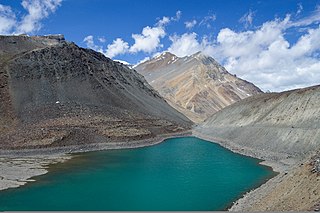
Suraj Tal, also called Tso Kamtsi or Surya Tal, is an 800 m (2,600 ft) long lake that lies just below the 4,890 m (16,040 ft) high Bara-lacha-la pass in Lahaul and Spiti district of the Indian state of Himachal Pradesh. It is the third-highest lake in India and the 21st-highest in the world. Suraj Tal Lake is just below the source of the Bhaga River that joins the Chandra River downstream at Tandi to form the Chandrabhaga River in Himachal Pradesh. The Chandrabhaga River is known as the Chenab as it enters the Jammu region of Jammu and Kashmir. The other major tributary of the Chandrabhaga, the Chandra, originates and flows south-east of the Bara-lacha La.

Khab is a small village in the state of Himachal Pradesh, India. It is located in the Sutlej river valley near the India-Tibet border. National Highway 5 connects Khab with state capital Shimla. Khab sangam is the confluence of Spiti river and Sutlej river. The Spiti river flowing through the spiti valley here meets the Sutlej, which originates from Mansarovar Lake in Tibet. The ancient monastery of Tashigang Gompa is nearby. The peak of Reo Purgil, which rises to 22,400 feet (6,800 m), is visible and the cold desert of Spiti lies across the nearby bridge.

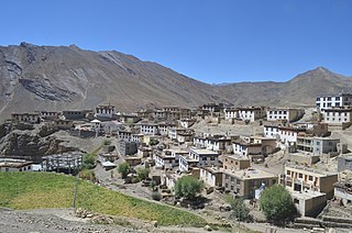
Kaza, also spelled Kaze, Karze, Karzey, is a town and the subdivisional headquarters of the remote Spiti Valley in the western Himalayas in the Lahaul and Spiti district of the northern Indian state of Himachal Pradesh. Spiti is a high altitude or cold desert having close similarities to the neighbouring Tibet and Ladakh regions in terms of terrain, climate and the Buddhist culture. Kaza, situated along the Spiti River at an elevation of 3,650 m (11,980 ft) above mean sea level, is the largest township and commercial center of the Spiti valley.

The Tangyud Monastery or Sa-skya-gong-mig Gompa at the village of Komic, two km southeast of Hikkim in the Spiti Valley of Himachal Pradesh, India, is built like a fortified castle on the edge of a deep canyon, with massive slanted mud walls and battlements with vertical red ochre and white vertical stripes which make them look much taller than they really are. It is one of the highest altitude gompas (monasteries) in India, at an altitude of 4,520 metres (14,830 ft), on the edge of a deep canyon and overlooking the town of Kaza, Spiti 4 km to the west. It is located on the periphery of the Kibber Wildlife Sanctuary.

Jispa is a village in Lahaul, in the Indian state of Himachal Pradesh.

Gemur Monastery is a Buddhist gompa, above the village of Gemur, Lahaul and Spiti district, Himachal Pradesh, northern India. The monastery dates from the first half of the 17th century.
Kibber, also Kibber Khas and Khyipur, is a village high in the Spiti Valley in the Himalayas at 4,270 m (14,010 ft) in Himachal Pradesh in northern India. It contains a monastery and is a base for visiting the Kibber Wildlife Sanctuary. It is located 19 km (12 mi) from Kaza and a bus service connects them in the summer months. Agriculture forms the backbone of the local economy and lush green fields are abundant. It is the base for visitors to the Kibber Wildlife Sanctuary, home to about 30 snow leopards. Treks to nearby peaks and to a high pass in the Zanskar range between Spiti and Ladakh start from Kibber.

Buddhism in the Himachal Pradesh state of India of has been a long-recorded practice. The spread of Buddhism in the region has occurred intermediately throughout its history. Starting in the 3rd century BCE, Buddhism was propagated by the Maurya Empire under the reign of Ashoka. The region would remain an important center for Buddhism under the Kushan Empire and its vassals. Over the centuries the following of Buddhism has greatly fluctuated. Yet by experiencing revivals and migrations, Buddhism continued to be rooted in the region, particularly in the Lahaul, Spiti and Kinnaur valleys.

National Highway 505, commonly called NH 505, is a national highway in India. It is a spur road of National Highway 5. NH 505 traverses the state of Himachal Pradesh in India. NH 505 is a high elevation road, covering the Kinnaur and Lahaul and Spiti districts of Himachal Pradesh, mainly running along the Spiti River in the Spiti Valley. The highway from Kaza to Gramphu remains closed for 6–9 months in a year due to heavy snowfall and the closure of Kunzum La pass at an elevation of 4,550 m (14,930 ft).
Skalzang Dorje is a former Indian archer. He competed in the men's individual and team events as a member of the India Olympic archery team at the 1996 Summer Olympics.

Losar Khas or Losar is a village on the right bank of the Spiti River in District Lahaul Spiti in the state of Himachal Pradesh, India. The Losar Gram Panchayat located in Losar is a local government body for the village of Losar Khas and 12 nearby villages in Development Block Spiti. Losar is located on NH-505 between Kaza in Spiti and Gramphoo in Lahaul.

Mud is a small village in the cold desert region of Spiti in Himachal Pradesh, India. Located at an altitude of 3,810 m (12,500 ft) on the left bank of the Pin River, a right bank tributary of the Spiti River, the village is nestled at the base of the Parbati range that towers almost vertically 1,600 m (5,200 ft) above. Mud is near the boundary of the Pin Valley National Park and is a convenient base for treks in the park, and to the neighbouring districts of Kullu and Kinnaur. It is the last village on the Spiti side of the Pin Parbati trek to Kullu and the Pin Bhaba trek to Kinnaur.
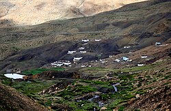
Langza is a small village located in Spiti Tehsil of Lahaul and Spiti district, Himachal Pradesh. It is set at the base of Chau Chau Kang Nilda mountain, also known as the Princess Mountain.
Demul is a village in Himachal Pradesh, India. It is located in Lahaul and Spiti district. The taluk is Spiti and pincode 172114. Demul is a remote settlement and situated at an elevation of 14,170 feet.