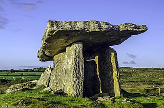
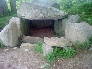
A dolmen or portal tomb is a type of single-chamber megalithic tomb, usually consisting of two or more upright megaliths supporting a large flat horizontal capstone or "table". Most date from the Late Neolithic period and were sometimes covered with earth or smaller stones to form a tumulus. Small pad-stones may be wedged between the cap and supporting stones to achieve a level appearance. In many instances, the covering has eroded away, leaving only the stone "skeleton".

A megalith is a large stone that has been used to construct a prehistoric structure or monument, either alone or together with other stones. There are over 35,000 in Europe alone, located widely from Sweden to the Mediterranean sea.

Cup and ring marks or cup marks are a form of prehistoric art found in the Atlantic seaboard of Europe (Ireland, Wales, Northern England, Scotland, France, Portugal, and Spain – and in Mediterranean Europe – Italy, Azerbaijan and Greece, as well as in Scandinavia and in Switzerland.

North Karnataka is a geographical region in Deccan plateau from 300 to 730 metres elevation that constitutes the region of the Karnataka state in India and the region consists of 14 districts. It is drained by the Krishna River and its tributaries the Bhima, Ghataprabha, Malaprabha, and Tungabhadra. North Karnataka lies within the Deccan thorn scrub forests ecoregion, which extends north into eastern Maharashtra.

The Carnac stones are an exceptionally dense collection of megalithic sites near the south coast of Brittany in northwestern France, consisting of stone alignments (rows), dolmens, tumuli and single menhirs. More than 3,000 prehistoric standing stones were hewn from local granite and erected by the pre-Celtic people of Brittany and form the largest such collection in the world. Most of the stones are within the Breton municipality of Carnac, but some to the east are within neighboring La Trinité-sur-Mer. The stones were erected at some stage during the Neolithic period, probably around 3300 BC, but some may date to as early as 4500 BC.
This article describes several characteristic architectural elements typical of European megalithic structures.

The dolmens of Jersey are neolithic sites, including dolmens, in Jersey. They range over a wide period, from around 4800 BC to 2250 BC, these dates covering the periods roughly designated as Neolithic, or “new stone age”, to Chalcolithic, or “copper age”.

Anegundi, previously called Kishkindha, is a village in Gangavathi, Koppal district, in the Indian state of Karnataka. It is older than Hampi, situated on the northern bank of the Tungabhadra River. Nimvapuram, a nearby village, has a mount of ash believed to be the cremated remains of the monkey king Vaali.

The greater Basque Country comprises the Autonomous Communities of the Basque Country and Navarre in Spain and the Northern Basque Country in France. The Prehistory of the region begins with the arrival of the first hominin settlers during the Paleolithic and lasts until the conquest and colonisation of Hispania by the Romans after the Second Punic War, who introduced comprehensive administration, writing and regular recordings.
Brahmagiri is an archaeological site located in the Chitradurga district of the state of Karnataka, India. Legend has it that this is the site where sage Gautama Maharishi and his wife Ahalya lived. He was one among seven noted Hindu saints. This site was first explored by Benjamin L. Rice in 1891, who discovered rock edicts of Emperor Ashoka here. These rock edicts indicated that the locality was termed as Isila and denoted the southernmost extent of the Mauryan empire. The Brahmagiri site is a granite outcrop elevated about 180 m. above the surrounding plains and measures around 500 m east-west and 100 m north-south. It is well known for the large number of megalithic monuments that have been found here. The earliest settlement found here has been dated to at least the 2nd millennium BC.
The Lancken-Granitz dolmens are a group of seven megalith tombs in the Lancken-Granitz municipality on Rügen, northern Germany. Erected during the middle Neolithic, when they were used by the Funnelbeaker culture, at least some were in use until the early Bronze Age. Three of them are encircled by solitary rocks forming either rectangles or a stone circle, one has a solitary "guardian stone" on its eastern side.

In the area of present-day Mecklenburg-Vorpommern, Germany, up to 5,000 megalith tombs were erected as burial sites by people of the Neolithic Funnelbeaker (TRB) culture. More than 1,000 of them are preserved today and protected by law. Though varying in style and age, megalith structures are common in Western Europe, with those in Mecklenburg-Vorpommern belonging to the youngest and easternmost—further east, in the modern West Pomeranian Voivodeship of Poland, monuments erected by the TRB people did not include lithic structures, while they do in the south (Brandenburg), west and north (Denmark).
Morera Thatte is an archaeological site consisting of a number of stone structures on Chikkabenkal hill near Gangavathi in Koppal district, India, dating back to the Stone Age. These houses are said to have been constructed 3,000 years ago. These houses have been built from stone slabs, with a circular opening serving as a door.
Byse is a village in the Shimoga district of Karnataka, India. It is located around 140 km from Mangalore, in the Nagara hobli of the Hosanagara taluka.

The simple dolmen or primeval dolmen is an early form of dolmen or megalithic tomb that occurs especially in Northern Europe. The term was defined by archaeologist, Ernst Sprockhoff, and utilised by Ewald Schuldt in publicising his excavation of 106 megalithic sites in the north German state of Mecklenburg-Vorpommern. The simple dolmen emerged in the early days of the development of megalithic monuments of the Funnelbeaker culture (TBK) and around 3,500 BC they appeared across almost the entire region covered by the stone cult structures of Nordic megalith architecture, but not in the Netherlands, in Lower Saxony west of the River Weser nor east of the River Oder and only once in Sweden.
Karatagi is a town and taluk headquarters of Karatagi taluk and it is located in Koppal District in Karnataka, India. It is one of the most important commercial centres in the district. The town is made up of multiple paddy fields, which are irrigated by the Tungabhadra Canal. Karatagi is known for its numerous rice mills, which can be found in the town and the surrounding areas.

Sidlaphadi near Badami in Karnataka, is a natural rock bridge and prehistoric rock shelter. It is located at about four km. in the middle of a shrub jungle near the historic town of Badami. A bridle and kutcha path through sandstone hills from Badami leads to Sidlaphadi and there is no metal road to the spot. Sidlaphadi literally means in Kannada the Rock of lightning, derived from gaping holes in the natural rock arch, which was formed when a lightning struck. The natural rock bridge structure looks like a wide arch between two sandstone boulders. The rock structure has large, gaping holes in the arch and allows sunlight to enter inside which provides the required light for interiors. It was also a shelter for hunter-gatherer prehistoric people.

Archaeology in India is mainly done under the supervision of the Archaeological Survey of India.
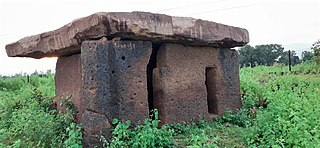
Hirapur dolmens, dating back to 2nd-3rd century BC asmaka mahajanapadas or satavahana dynasty era, are 4 dolmens made of megalithic laterite in the general area of Hirapur village on NH-930 in Chimur tehsil of Chandrapur district of Maharashtra.


