This article needs additional citations for verification .(December 2014) |
The history of Hsinchu extends over more than 400 years, making it one of the oldest cities in northern Taiwan.
This article needs additional citations for verification .(December 2014) |
The history of Hsinchu extends over more than 400 years, making it one of the oldest cities in northern Taiwan.
The first settlers in the city of Hsinchu were the aboriginal plains tribe known as Taokas. [1] Prior to the arrival of the Han Chinese, the area around Hsinchu was held by the Taokas, the Saisiyat, and the Atayal. Originally, they settled by the coast of the Siangshan Wetlands and then gradually expanded northeast, cultivating the area.
The Spanish occupied northern Taiwan in the 17th century. Catholic missionaries reached the settlement of Tek-kham in 1626. The Hokkien name, literally meaning "Bamboo Barrier", may transcribe an aboriginal[ which? ] word for "seashore".[ citation needed ] In 1642, the Dutch drove out the Spanish from Taiwan. Dutch Formosa ended with the Siege of Fort Zeelandia in 1662. The Kingdom of Tungning then ruled part of southwestern Taiwan in the name of the Ming until 1683.
In 1684, Zhuluo County was established during Qing Dynasty rule, initially encompassing the underdeveloped northern two-thirds of Taiwan. Wang Shih-chieh , from Kinmen, was the first Han settler to reside in Tek-kham and cultivate farmland. Over 180 others followed, establishing a settlement alongside what later became Dongqian Street in East District, Hsinchu, in 1711. [2] [3]
By 1723, the Qing Empire split Zhuluo into three sections. One of them was Tamsui Subprefecture, corresponding to modern-day Taipei, New Taipei, Keelung, Taoyuan, Hsinchu City and County, and Miaoli.
Tek-kham was surrounded by bamboo groves used as defense walls and gates.[ citation needed ] In 1825, these natural defenses were removed and replaced with brick and stone walls, except the East Gate.
In 1877, Tamsui Subprefecture was abolished. As part of the reorganization of Taiwan by Shen Baozhen, the viceroy of Liangjiang, Zhuqian Subprefecture (i.e., Tek-kham) was raised to the level of a county and renamed Hsinchu (i.e., Sin-tek or Xinzhu) in 1878. [4] By 1887, Taipeh Prefecture consisted of the counties of Tamsui, Gilan, and Hsinchu.
In the late 19th century, the Hoklo dominated the coastal plain area, forcing the Saisiyat and Atayal tribes to move to Jianshi and Wufeng, while the Hakka and Taokas settled together in the river valleys and hills area.
By the end of 1893, the railway from Keelung crossed the Taipei Bridge and regular service was opened over the entire 60 mi (97 km) line. [5]
During the first years of Japanese occupation following the First Sino-Japanese War, the political divisions of the island were changed frequently. By 1901, the city—known at the time as Shinchiku—was the head of a subprefecture ("chō"), one of twenty spread around the island. [6] It was the main administrative center between Taipei (then "Taihoku") and Taichung (then "Taichū") and among the province's most populous towns. In 1904, its 16,371 residents ranked it in 7th place, behind Keelung and ahead of Changhua ("Shoka"). [7]
Roads and railways were built but many traditional buildings—even the city wall surrounding the former headquarters of the Tamsui Subprefecture —were demolished. During this time, "Shinchiku" first became a center for glass making.
"Shinchiku" was raised to town ( 街 ) status in 1920; a town district office was established within the Shinchiku District of Shinchiku Prefecture. It was raised to city status in 1930; the town district office becoming a city office. At the same time, it became the seat of Shinchiku Prefecture, which eventually encompassed modern-day Hsinchu City, Hsinchu County, Taoyuan City, and Miaoli County. In 1941, its prefecture was expanded, annexing Xiangshan ("Kōzan"). Jiugang ( t 舊 港 莊 , s 旧 港 庄 , "Old Harbor Village" and the Japanese "Kyūminato") and Liujia ( t 六 家 莊 , s 六 家 庄 , "Six-Family Village" and the Japanese "Rokka") merged to become Zhubei ( t 竹 北 莊 , s 竹 北 庄 , "North of Xinzhu" and the Japanese "Chikuhoku").
After the handover of Taiwan from Japan to the Kuomintang-led Republic of China after World War II, they established the Hsinchu City Government and focused on the industrial development of the area. Hsinchu County was established to be part of Taiwan Province on 25 December 1945.
In 1946, the Take-Over Committee dissolved and replaced by the Hsinchu County Government, located in Taoyuan. As the administrative districts were readjusted, Hsinchu was granted city status. It used the old prefecture office as its city hall at 120 Chung Cheng Road. In February 1946, representative congresses were formed for seven district offices. On April 15, the city congress was formed. Provincial representatives were elected from among the city legislators.
On 16 August 1950, the administrative districts on Taiwan were re-adjusted once more, demarcating 16 counties and 5 provincially-governed cities.
In 1980, the government established the "Science Park", which significantly improved the area's economy. In June 1982, under presidential order, the Xiangshan Township of Hsinchu County merged into Hsinchu City. A new municipal government was formally established on 1 July 1982, comprising 103 villages and 1,635 neighborhoods. These were organized into the East, North, and Xiangshan districts by 1 November. By June 1983, the new government consisted of three bureaus (Civil Service, Public Works, and Education), four departments (Finance, Social Welfare, Compulsory Military Service, and Land Affairs), four offices (Secretary, Planning, Personnel, and Auditing), and 49 various sections. The Police Department, Tax Department, and Medicine and Hygiene Department were considered affiliate institutions.
From 1994 to 1999, as Taiwan made its transition from authoritarian rule to a representative democracy and the mostly pro forma provincial level of government began to be dissolved, regulations were established for the self-government of Hsinchu. A deputy mayor, consumer officer, and three consultants were added to the city government. In 2002, the city added a Bureau of Labor and transferred Compulsory Military Service to the Department of Civil Service.
Hsinchu is located in a favourable spot: it is about one hour from Taipei, Taoyuan International Airport, and Taichung. The Hsinchu Science and Industrial Park develops high-tech research and products, specialising in the areas of semiconductors, computers, information technology and optical engineering.

Hsinchu is a city located in northwestern Taiwan. It is the most populous city in Taiwan Province not among the special municipalities, with estimated 450,655 inhabitants. Hsinchu is a coastal city bordering the Taiwan Strait to the west, Hsinchu County to the north and east, and Miaoli County to the south. Nicknamed the Windy City for its strong northeastern monsoon during the autumn and winter seasons.
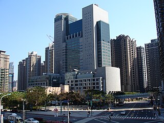
New Taipei City is a special municipality located in northern Taiwan. The city is home to an estimated population of 3,974,683 as of 2022, making it the most populous city of Taiwan, and also the second largest special municipality by area, behind Kaohsiung. New Taipei City neighbours Keelung to the northeast, Yilan County to the southeast, and Taoyuan to the southwest, and completely encloses the city of Taipei. Banqiao District is its municipal seat and biggest commercial area.

Taoyuan District, formerly known as Taoyuan City (桃園市) prior to the establishment of the special municipality of Taoyuan in 2014, is a district of Taoyuan City in northwestern Taiwan. The municipal seat of Taoyuan City is situated within its borders. It is the most populous district among the 12 districts of Taoyuan City, and the second most populous among the districts of Taiwan, with the most populous being Banqiao District in New Taipei City.

Hsinchu County is a county in north-western Taiwan. The population of the county is mainly Hakka; with a Taiwanese aboriginal minority in the southeastern part of the county. Zhubei is the county capital, where the government office and county office is located. A portion of the Hsinchu Science Park is located in Hsinchu County.

Zhubei is a city in Taiwan located in Hsinchu County, Taiwan. It is one of the fastest-growing settlements in Taiwan, with a population gain of 51,000 between 2010 and 2019, the highest of any township/city or district. The city has attracted migration both because of its proximity to Hsinchu City and the Hsinchu Science and Technology Park, and because the Hsinchu County government has focused most of its infrastructure here.
Highways in Taiwan are classified into five types:

Wanli District, known in Basay as Masu, is a rural district on the rocky seacoast in northeastern New Taipei City in northern Taiwan. Wanli is a popular tourist destination and the site of the Cape Yeliu Miocene Formation which features distinctive hoodoo outcrops. The "Queen's Head" outcrop is a Taiwanese icon and serves as an informal trademark for the township. Kataw in the adjacent Jinshan District features the Wanli Taiwanese hot springs area, which is connected with the Jinshan Hot Springs (金山溫泉).
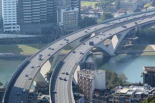
National Freeway 3, also known as Formosa Freeway, is a freeway in Taiwan. It is the second north–south freeway in Taiwan, beginning in Keelung City at Jijin Interchange on the provincial highway 2 and ending in Linbian, Pingtung on the provincial highway 17. It is the longest freeway in Taiwan with a total length of 431.5 km (268.1 mi). The freeway is also the only one in Taiwan to have a spur route, Freeway 3A.

Guishan District is a district in northeastern Taoyuan City, Taiwan.

The Japanese invasion of Taiwan was a conflict between the Empire of Japan and the armed forces of the short-lived Republic of Formosa following the Qing dynasty's cession of Taiwan to Japan in April 1895 at the end of the First Sino-Japanese War. The Japanese sought to take control of their new possession, while the Republican forces fought to resist Japanese occupation. The Japanese landed near Keelung on the northern coast of Taiwan on 29 May 1895, and in a five-month campaign swept southwards to Tainan. Although their advance was slowed by guerrilla activity, the Japanese defeated the Formosan forces whenever they attempted to make a stand. The Japanese victory at Baguashan on 27 August, the largest battle ever fought on Taiwanese soil, doomed the Formosan resistance to an early defeat. The fall of Tainan on 21 October ended organised resistance to Japanese occupation, and inaugurated five decades of Japanese rule in Taiwan.
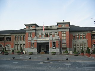
Shinchiku Prefecture was one of the administrative divisions of Taiwan during the Japanese era. The prefecture consisted of modern-day Hsinchu City, Hsinchu County, Taoyuan City, and Miaoli County.
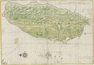
The recorded history of Taipei began with the Han Chinese settling of the Taipei Basin in 1709, leading up to the formation of the national capital of Taiwan and high-tech industry hub and that is now Taipei City. Other notable dates include the 1895 annexation of Taiwan by Japan, during which Taipei began to grow more rapidly, and in the 1950s, the USA's provision of financial assistance to the Republic of China government, after which the city continued on a path of fast structural and industrial growth.
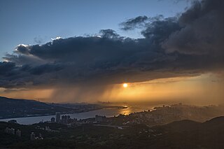
The Tamsui River (alternatively Danshui River, Chinese: 淡水河; pinyin: Dànshǔi Hé; Wade–Giles: Tan4-shui3 Ho2; Pe̍h-ōe-jī: Tām-chúi-hô; lit. 'Freshwater River') is third longest river in Taiwan after Zhuoshui River and Gaoping River, with a total length of 158.7 km (98.6 mi), flowing through Hsinchu County, Taoyuan, Taipei and New Taipei City. It is located in northern part of the island.

Tamsui District is a seaside district in New Taipei, Taiwan. It is named after the Tamsui River; the name means "fresh water". The town is popular as a site for viewing the sun setting into the Taiwan Strait. Though modest in size, it has a large role in Taiwanese culture.
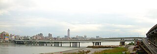
Taipei Bridge is a motor-vehicle bridge across the Tamsui River connecting Taipei with Sanchong District, New Taipei City in Taiwan. A central span carries automobile and some motorcycle traffic while narrower spans on either side carry most motorcycle traffic along with bicycle pedestrian traffic. The central bridge is 481.6 meters in length.
Districts are administrative subdivisions of the Republic of China (Taiwan)'s special municipalities of the second level and provincial cities of the third level formerly under its provinces. There are two types of district in the administrative scheme.

Zhuluo County was a political division in Taiwan from 1684 to 1787, during Qing Dynasty rule of the island. Initially encompassing the underdeveloped northern two-thirds of Taiwan, the county shrank in size as the population and economy of the north and central western plains grew and new counties were created out of the developed areas; the Zhuluo county was eventually limited to a under-developed area in south-western Taiwan. In 1787 the county underwent further restructuring and was renamed Chiayi County.

The Dahan River is a river in northern Taiwan. It originates in Hsinchu County and then flows through Taoyuan City and New Taipei City for 135 km, before it joins Xindian River in Taipei to form the Tamshui River. The upper reaches of the Dahan are also known as Takekan Creek or Taigang Creek (泰崗溪). An alternative historical name for the Dahan is the Shihmen River (石門溪).
Taipeh Prefecture was a Qing dynasty prefecture created from the northern part of Taiwan Prefecture, Qing-era Taiwan in 1875, while the island was still part of Fujian Province. It consisted of a region surrounding modern-day Taipei, including present-day Hsinchu, Hsinchu County, Taoyuan City, New Taipei City, Taipei, Keelung, and Yilan County. The reorganization started after Imperial Commissioner Shen Pao-chen demanded that another prefecture be added in Taiwan to revamp the administrative organization of the northern area of the island. The walls of the prefecture capital were completed in 1884.
The architecture of Taiwan can be traced back to stilt housing of the aborigines in prehistoric times; to the building of fortresses and churches in the north and south used to colonize and convert the inhabitants during the Dutch and Spanish period; the Tungning period when Taiwan was a base of anti-Qing sentiment and Minnan-style architecture was introduced; in Qing dynasty period, a mix of Chinese and Western architecture appeared and artillery battery flourished during Qing's Self-Strengthening Movement; During the Japanese rule of Taiwan, the Minnan, Japanese and Western culture were main influencers in architectural designs and saw the introduction and use of reinforced concrete. Due to excessive Westernization as a colony, after the retrocession of Taiwan to the Republic of China in 1945 from Japan at the end of World War II, Chinese classical style became popular and entered into international mainstream as a postmodern design style. Today, Taiwanese architecture has undergone much diversification, every style of architecture can be seen.