
In geography, the temperate climates of Earth occur in the middle latitudes, which span between the tropics and the polar regions of Earth. These zones generally have wider temperature ranges throughout the year and more distinct seasonal changes compared to tropical climates, where such variations are often small and usually only have precipitation differences.

Temperate broadleaf and mixed forest is a temperate climate terrestrial habitat type defined by the World Wide Fund for Nature, with broadleaf tree ecoregions, and with conifer and broadleaf tree mixed coniferous forest ecoregions.

A Mediterranean climate, also called a dry summer climate, described by Köppen as Cs, is a temperate climate type that occurs in the lower mid-latitudes. Such climates typically have dry summers and wet winters, with summer conditions ranging from warm to hot and winter conditions typically being mild to cool. These weather conditions are typically experienced in the majority of Mediterranean-climate regions and countries, but remain highly dependent on proximity to the ocean, altitude and geographical location.

The subtropical zones or subtropics are geographical and climate zones to the north and south of the tropics. Geographically part of the temperate zones of both hemispheres, they cover the middle latitudes from 23°26′10.0″ (or 23.43612°) to approximately 35° north and south. The horse latitudes lie within this range.

Tropical climate is the first of the five major climate groups in the Köppen climate classification identified with the letter A. Tropical climates are defined by a monthly average temperature of 18 °C (64.4 °F) or higher in the coolest month, featuring hot temperatures and high humidity all year-round. Annual precipitation is often abundant in tropical climates, and shows a seasonal rhythm but may have seasonal dryness to varying degrees. There are normally only two seasons in tropical climates, a wet (rainy/monsoon) season and a dry season. The annual temperature range in tropical climates is normally very small. Sunlight is intense in these climates.
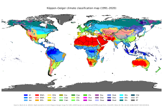
The Köppen climate classification is one of the most widely used climate classification systems. It was first published by German-Russian climatologist Wladimir Köppen (1846–1940) in 1884, with several later modifications by Köppen, notably in 1918 and 1936. Later, German climatologist Rudolf Geiger (1894–1981) introduced some changes to the classification system in 1954 and 1961, which is thus sometimes called the Köppen–Geiger climate classification.

A semi-arid climate, semi-desert climate, or steppe climate is a dry climate sub-type. It is located on regions that receive precipitation below potential evapotranspiration, but not as low as a desert climate. There are different kinds of semi-arid climates, depending on variables such as temperature, and they give rise to different biomes.

A humid continental climate is a climatic region defined by Russo-German climatologist Wladimir Köppen in 1900, typified by four distinct seasons and large seasonal temperature differences, with warm to hot summers, and cold and snowy winters. Precipitation is usually distributed throughout the year, but often these regions do have dry seasons. The definition of this climate in terms of temperature is as follows: the mean temperature of the coldest month must be below 0 °C (32.0 °F) or −3 °C (26.6 °F) depending on the isotherm, and there must be at least four months whose mean temperatures are at or above 10 °C (50 °F). In addition, the location in question must not be semi-arid or arid. The cooler Dfb, Dwb, and Dsb subtypes are also known as hemiboreal climates. Although amount of snowfall is not a factor used in defining the humid continental climate, snow during the winter in this type of climate is almost a guarantee, either intermittently throughout the winter months near the poleward or coastal margins, or persistently throughout the winter months elsewhere in the climate zone.

The dry season is a yearly period of low rainfall, especially in the tropics. The weather in the tropics is dominated by the tropical rain belt, which moves from the northern to the southern tropics and back over the course of the year. The temperate counterpart to the tropical dry season is summer or winter.

Abbot Pass lies between Mount Lefroy and Mount Victoria, in the divide between the valleys of Lake O'Hara and Lake Louise. It was named for Philip Stanley Abbot who died in 1896 in an attempt to climb Mount Lefroy with Charles Fay, Charles Thompson, and George T. Little.

Homalin or Hommalinn is a small town in north-western Burma and capital of the Homalin Township in Hkamti District of the Sagaing Region. The town lies on the Chindwin River and is served by Homalin Airport.

Blackcomb Peak is a mountain located east of Whistler, British Columbia that forms the boundary between the Whistler Blackcomb ski resort and Garibaldi Provincial Park. Like Whistler Mountain, it is located on the edge of Garibaldi Provincial Park and the ski lifts are often used to access the park, particularly for the Spearhead Traverse.

Climate classifications are systems that categorize the world's climates. A climate classification may correlate closely with a biome classification, as climate is a major influence on life in a region. One of the most used is the Köppen climate classification scheme first developed in 1884.

A humid subtropical climate is a temperate climate type characterized by hot and humid summers, and cool to mild winters. These climates normally lie on the southeast side of all continents, generally between latitudes 25° and 40° and are located poleward from adjacent tropical climates, and equatorward from either humid continental or oceanic climates. It is also known as warm temperate climate in some climate classifications.

Lapland Nature Reserve is a Russian zapovednik in Murmansk Oblast, Russia, above the Arctic Circle. Officially established in 1957, the reserve protects an area of 2,784 km2 (1,075 sq mi) to the northwest of Lake Imandra, including 86 km² of inland water. The terrain is mountainous tundra and northern taiga. Since 1985 the zapovednik has been designated by UNESCO as a biosphere reserve. The name refers to the cultural area of Lapland, now preferably called Sápmi.
Seoul, the capital of South Korea, features a humid continental climate with dry winter, called "Dwa" in the Köppen climate classification, with four highly distinct seasons. In summer the influence of the North Pacific high-pressure system brings hot, humid weather with temperatures soaring as high as 35 °C (95 °F) on occasion. In winter the city is topographically influenced by expanding Siberian High-pressure zones and prevailing west winds bring colder air to Korea. The bitterly cold days are commonly known to come in three-day cycles regulated by rising and falling pressure systems. The most pleasant seasons for most people in the city are spring and autumn, when azure skies and comfortable temperatures are typical. Most of Seoul's precipitation falls in the summer monsoon period between June and September, as a part of East Asian monsoon season.
Beringia National Park is on the eastern tip of Chukotka Autonomous Okrug ("Chukotka"), the most northeastern region of Russia. It is on the western side of the Bering Strait.

Yugansky Nature Reserve is a Russian 'zapovednik' in the basin of the Bolshoy Yugan River, a left tributary of the Ob River. The reserve is in the central part of the West Siberian Plain, in the southern part of the Middle Ob lowlands. It is situated in the Surgutsky District of the Khanty-Mansi Autonomous Okrug, about 500 km due north of the city of Omsk. The reserve was created in 1982, and covers an area of 648,636 ha (2,504.40 sq mi).
Zeya Nature Reserve is a Russian 'zapovednik' located over the mountainous headwaters of the Zeya River, on the eastern end of the Tukuringra Range, where it joins the Dzhagdy, in the Amur Region of the Russian Far East. It was created in part to serve as a "reference plot" for the study of the ecological impact of the Zeya Dam and the Zeya Reservoir which were built in the 1960s and 1970s. The ground cover in the reserve is primarily taiga, of mostly larch and Mongolian oak. The reserve is situated 13 km north of the city of Zeya, in the Zeysky District of Amur Oblast.

Khibiny National Park protects a mountainous region of taiga and tundra on the Khibiny Mountains and Lovozero Massif of the western Kola Peninsula in northwestern Russia. The mountains contain commercially important minerals, and the park's borders reflect the need to balance three uses - protection of the unique natural environment, recreation, and industrial mining. The park was officially created in 2018, and is located in the districts of Kirovsk and Olenegorsk in Murmansk Oblast.
