Sagaing Region is an administrative region of Myanmar, located in the north-western part of the country between latitude 21° 30' north and longitude 94° 97' east. It is bordered by India's Nagaland, Manipur, and Arunachal Pradesh states to the north, Kachin State, Shan State, and Mandalay Region to the east, Mandalay Region and Magway Region to the south, with the Ayeyarwady River forming a greater part of its eastern and also southern boundary, and Chin State and India to the west. The region has an area of 93,527 square kilometres (36,111 sq mi). In 1996, it had a population of over 5,300,000 while its population in 2012 was 6,600,000. The urban population in 2012 was 1,230,000 and the rural population 5,360,000. The capital city and the largest city of Sagaing Region is Monywa.
Hkamti, Khampti or Khamti may refer to:

Putao is the town in Kachin State, Myanmar and the principal town in Putao Township. The area around Putao is famous for its variety of birds and rare orchids, especially the so-called "Black Orchid" found in the mountains surrounding Putao. Myanmar's highest mountain, Hkakabo Razi, and other snow-capped peaks are visible from Putao.

Hkamti Long, also known as Khandigyi was a Shan state in what is today Burma. It was an outlying territory, located by the Mali River, north of Myitkyina District, away from the main Shan State area in present-day Kachin State. The main town was Putao.

The Khamti language is a Southwestern Tai language spoken in Myanmar and India by the Khamti people. It is closely related to, and sometimes considered a dialect of, Shan.

Homalin or Hommalinn is a small town in north-western Burma and capital of the Homalin Township in Hkamti District of the Sagaing Region. The town lies on the Chindwin River and is served by Homalin Airport.

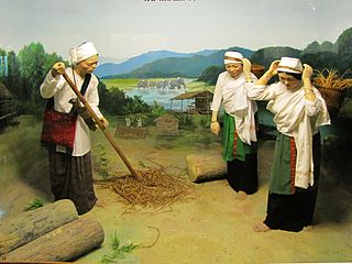
The Tai Khamti, also known as the Hkamti Shan or simply as Khamti, are a Tai ethnic group of India, China and Myanmar. The Tai-Khamti are followers of Theravada Buddhism. The Tai-Khamti have their own script for their language, known as 'Lik Tai', which originated from the Shan (Tai) script of Myanmar. Their mother tongue is known as Khamti language. It is a Tai language, closely related to Thai and Lao.

Kalaymyo Airport is a domestic airport serving Kalaymyo, a town in the Sagaing Division of Myanmar. It is an airport at Kalay, an extension of a British-built Second World War airstrip that was used to ferry troops and supplies into Myanmar during the British reconquest of Myanmar in 1945. The airport is located in the middle of the town. The airport is at an elevation of 499 feet ; it has 79 meters wide and 1,677 meters long runway with a blacktopped surface.
Leshi, is a town in Naga Hills of Sagaing Division on the north-west frontier of Burma. According to the new 2008 Constitution of the military regime, it will now be grouped together with Lahe and Nanyun in Naga Self-Administered Zone. Leshi is reached via Htamanthi across the Chindwin River by boat from Homalin, and there are domestic flights from Yangon and Mandalay to Homalin.
Khamti, Hkamti, Singkawng, Kanti or Kantee is a town in Hkamti District, Sagaing Division, in north-western Myanmar. It is the administrative center for both the district and Hkamti Township.
Hkamti District or Khamti District is a district in northern Sagaing Division of Burma (Myanmar). Its administrative center is the town of Singkaling Hkamti.

Hkamti Township or Khamti Township is a township in Hkamti District in the Sagaing Region of Burma (Myanmar). The principal town is Hkamti. As of 2014 the township had a population of 47,658 people and covered an area of 8,174 square kilometres (3,156 sq mi). The township is dominated by the Chindwin River and its tributaries as well as thickly forested areas. Nearly half the active working population are employed in agriculture, forestry or fishing. The township is a producer of rice and has gold and jade reserves.

Homalin Township is a township in Hkamti District in the Sagaing Region of Myanmar. The principal town is Homalin. The principal rivers flowing through the township are the Chindwin River form north to south and the Uyu River from east to west, joining the Chindwin near Homalin town.

Leshi Township or Layshi Township is a mountainous township located within the Naga Self-Administered Zone of Sagaing Region, Myanmar. It is also part of the Naga Self-Administered Zone. The principal town is Leshi.
Hkampti is a small village in Hkamti Township in Hkamti District in the Sagaing Region of northwestern Burma.
Mepok or Mei Poke is a village and village tract in Hkamti Township in Hkamti District in the Sagaing Region of northwestern Burma. At the time of the 2014 census the village tract had a population of 255 people.
Hunaung is a village in Homalin Township, Hkamti District, in the Sagaing Region of northwestern Burma. It lies on the Chindwin River on the other side of the river from Homalin Airport. It is part of the Hin Naung village tract.
Khaungkhan is a village on the Chindwin River in Homalin Township, Hkamti District, in the Sagaing Region of northwestern Myanmar. It is located next to Homalin Airport. It is part of the Khaungkhan village tract.
Lainong Naga, or Htang Ngan, is a Sino-Tibetan language spoken in Burma. Lainong Naga is spoken in about 32 villages of Lahe Township and northwestern Hkamti Township, Naga Self-Administered Zone, Sagaing Division, Myanmar (Ethnologue). Dialects are Zëūdiāng.


