List of airports in Myanmar

Last updated

Map of Burma (Myanmar) Burma-CIA WFB Map.png
Map of Burma (Myanmar)

This is a list of airports in Myanmar (Burma), grouped by type and sorted by location.

Contents

Due to the impact of the Myanmar civil war, many airports have suspended operations.

The country is bordered by People's Republic of China to the northeast, Laos to the east, Thailand to the southeast, Bangladesh to the west, India to the northwest, the Bay of Bengal to the southwest, and the Andaman Sea to the south. The country is divided into 14 administrative subdivisions, which include 7 states (pyi-ne) and 7 divisions (tyne). Its capital is Naypyitaw (Nay Pyi Taw) and its largest city (and prior capital) is Yangon.

Department of Civil Aviation will publish statistic data for every airports with commercial flights every months, the data includes number of flights, international and domestic passenger and cargo traffics, etc. [1]
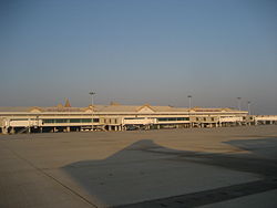
Airports

Airport names shown in bold have scheduled passenger service on commercial airlines.

Location served Region/State ICAO IATA Airport name Coordinates
International airports
Mandalay / Tada-U Mandalay Region VYMDMDL Mandalay International Airport 21°42′07″N095°58′40″E / 21.70194°N 95.97778°E / 21.70194; 95.97778 (Mandalay International Airport)
Yangon (Rangoon) Yangon Region VYYYRGN Yangon International Airport 16°54′26″N096°07′59″E / 16.90722°N 96.13306°E / 16.90722; 96.13306 (Yangon International Airport)
Naypyidaw (Naypyitaw) Mandalay Region VYNTNYT Nay Pyi Taw International Airport (Ela Airport) 19°37′24″N096°12′03″E / 19.62333°N 96.20083°E / 19.62333; 96.20083 (Naypyidaw Airport)
Bago (Bago) Bago Region Hanthawaddy International Airport (Under Construction) 17°18′4″N096°25′41″E / 17.30111°N 96.42806°E / 17.30111; 96.42806 (Hanthawaddy Airport)
Domestic airports
Ann Rakhine State VYANVBA Ann Airport 19°46′08″N094°01′34″E / 19.76889°N 94.02611°E / 19.76889; 94.02611 (Ann Airport)
Bagan / Nyaung-U Mandalay Region VYBGNYU Nyaung U Airport 21°10′43″N094°55′48″E / 21.17861°N 94.93000°E / 21.17861; 94.93000 (Nyaung U Airport)
Bhamo (Banmaw) Kachin State VYBMBMO Bhamo Airport (Banmaw Airport) 24°16′15″N097°14′49″E / 24.27083°N 97.24694°E / 24.27083; 97.24694 (Bhamo Airport)
Bokpyin (Bokepyin) Tanintharyi Region VYBP Bokpyin Airport 11°16′N098°46′E / 11.267°N 98.767°E / 11.267; 98.767 (Bokpyin Airport)
Mandalay Mandalay Region VYCZVBC Chanmyathazi Airport 21°56′25″N096°05′22″E / 21.94028°N 96.08944°E / 21.94028; 96.08944 (Mandalay Chanmyathazi Airport)
Dawei (Tavoy) Tanintharyi Region VYDWTVY Dawei Airport 14°06′13″N098°12′13″E / 14.10361°N 98.20361°E / 14.10361; 98.20361 (Dawei Airport)
Heho Shan State VYHHHEH Heho Airport 20°44′49″N096°47′31″E / 20.74694°N 96.79194°E / 20.74694; 96.79194 (Heho Airport)
Homalin (Hommalin) Sagaing Region VYHLHOX Homalin Airport (Hommalin Airport) 24°53′58″N094°54′50″E / 24.89944°N 94.91389°E / 24.89944; 94.91389 (Homalin Airport)
Kalay (Kale) Sagaing Region VYKLKMV Kalaymyo Airport 23°11′19″N094°03′03″E / 23.18861°N 94.05083°E / 23.18861; 94.05083 (Kalaymyo Airport)
Kawthaung (Kawthoung) Tanintharyi Region VYKTKAW Kawthaung Airport 10°02′57″N098°32′16″E / 10.04917°N 98.53778°E / 10.04917; 98.53778 (Kawthaung Airport)
Kengtung (Kengtong, Kyaingtong) Shan State VYKGKET Kengtung Airport 21°18′05″N099°38′09″E / 21.30139°N 99.63583°E / 21.30139; 99.63583 (Kengtung Airport)
Khamti Sagaing Region VYKIKHM Khamti Airport 25°59′18″N095°40′28″E / 25.98833°N 95.67444°E / 25.98833; 95.67444 (Khamti Airport)
Kyaukpyu (Kyauk Pyu) Rakhine State VYKPKYP Kyaukpyu Airport 19°25′35″N093°32′05″E / 19.42639°N 93.53472°E / 19.42639; 93.53472 (Kyaukpyu Airport)
Lashio Shan State VYLSLSH Lashio Airport 22°58′40″N097°45′07″E / 22.97778°N 97.75194°E / 22.97778; 97.75194 (Lashio Airport)
Loikaw Kayah State VYLKLIW Loikaw Airport 19°41′29″N097°12′53″E / 19.69139°N 97.21472°E / 19.69139; 97.21472 (Loikaw Airport)
Magwe Magway Region VYMWMWQ Magwe Airport 20°09′56″N094°56′28″E / 20.16556°N 94.94111°E / 20.16556; 94.94111 (Magwe Airport)
Manaung Rakhine State VYMNMGU Manaung Airport 18°50′45″N093°41′20″E / 18.84583°N 93.68889°E / 18.84583; 93.68889 (Manaung Airport)
Mawlamyine (Mawlamyaing) Mon State VYMMMNU Mawlamyaing Airport (Mawlamyine Airport) 16°26′41″N097°39′38″E / 16.44472°N 97.66056°E / 16.44472; 97.66056 (Mawlamyaing Airport)
Mong Hsat (Monghsat) Shan State VYMSMOG Monghsat Airport (Mong Hsat Airport) 20°31′00″N099°15′24″E / 20.51667°N 99.25667°E / 20.51667; 99.25667 (Monghsat Airport)
Monywa (Monywar) Sagaing Region VYMYNYW Monywa Airport (Monywar Airport) 22°14′N095°07′E / 22.233°N 95.117°E / 22.233; 95.117 (Monywa Airport)
Myeik (Mergui) Tanintharyi Region VYMEMGZ Myeik Airport 12°26′23″N098°37′17″E / 12.43972°N 98.62139°E / 12.43972; 98.62139 (Myeik Airport)
Myitkyina Kachin State VYMKMYT Myitkyina Airport 25°23′01″N097°21′06″E / 25.38361°N 97.35167°E / 25.38361; 97.35167 (Myitkyina Airport)
Pathein (Bassein) Ayeyarwady Region VYPNBSX Pathein Airport 16°48′54″N094°46′47″E / 16.81500°N 94.77972°E / 16.81500; 94.77972 (Pathein Airport)
Putao Kachin State VYPTPBU Putao Airport 27°19′47″N097°25′34″E / 27.32972°N 97.42611°E / 27.32972; 97.42611 (Putao Airport)
Sittwe (Akyab) Rakhine State VYSWAKY Sittwe Airport 20°07′57″N092°52′21″E / 20.13250°N 92.87250°E / 20.13250; 92.87250 (Sittwe Airport)
Falam (Surbung) Chin State VYFSSUR Surbung Airport (Under construction) 22°56′21″N93°36′55″E / 22.939167°N 93.615333°E / 22.939167; 93.615333 (Surbung Airport)
Tachileik (Tachilek) Shan State VYTLTHL Tachilek Airport 20°29′01″N099°56′07″E / 20.48361°N 99.93528°E / 20.48361; 99.93528 (Tachilek Airport)
Thandwe (Sandoway) Rakhine State VYTDSNW Thandwe Airport 18°27′38″N094°18′00″E / 18.46056°N 94.30000°E / 18.46056; 94.30000 (Thandwe Airport)
Military airports
Anisakan Mandalay Region VYAS Anisakan Airport 21°57′19″N096°24′21″E / 21.95528°N 96.40583°E / 21.95528; 96.40583 (Anisakan Airport)
Coco Islands (Great Coco Island) Yangon Region VYCI Coco Island Airport 14°08′29″N093°22′06″E / 14.14139°N 93.36833°E / 14.14139; 93.36833 (Coco Island Airport)
Hmawbi (Hmawby) Yangon Region VYHB Hmawbi Air Base 17°07′N96°04′E / 17.117°N 96.067°E / 17.117; 96.067 (Hmawbi Air Base)
Hpa-an (Pa-An) Kayin State VYPAPAA Hpa-An Airport 16°53′37″N097°40′28″E / 16.89361°N 97.67444°E / 16.89361; 97.67444 (Hpa-An Airport)
Kyauktu (Kyaukhtu) Magway Region VYXG Kyauktu South Airport 21°24′26″N094°07′31″E / 21.40722°N 94.12528°E / 21.40722; 94.12528 (Kyauktu South Airport)
Meiktila Mandalay Region VYML Meiktila Air Base 20°53′N095°53′E / 20.883°N 95.883°E / 20.883; 95.883 (Meiktila Air Base)
Meiktila Mandalay Region VYST Shante Air Base 20°56′30″N095°54′52″E / 20.94167°N 95.91444°E / 20.94167; 95.91444 (Shante Air Base)
Myitkyina Kachin State VYNP Nampong Air Base 25°21′15″N097°17′42″E / 25.35417°N 97.29500°E / 25.35417; 97.29500 (Nampong Air Base)
Namsang Shan State VYNSNSG Namsang Air Base 20°53′20″N97°44′10″E / 20.88889°N 97.73611°E / 20.88889; 97.73611 (Namsang Air Base)
Pakokku Magway Region VYPUPKK Pakokku Airport 21°24′N095°06′E / 21.400°N 95.100°E / 21.400; 95.100 (Pakokku Airport)
Taungoo Bago Division VYTOTGO Taungoo Air Base 19°01′48″N96°25′00″E / 19.03000°N 96.41667°E / 19.03000; 96.41667 (Taungoo Air Base)
Disused airports
Gangaw Magway Region VYGGGAW Gangaw Airport 22°10′29″N094°08′04″E / 22.17472°N 94.13444°E / 22.17472; 94.13444 (Gangaw Airport)
Gwa Rakhine State VYGWGWA Gwa Airport 17°36′N094°35′E / 17.600°N 94.583°E / 17.600; 94.583 (Gwa Airport)
Hpapun (Papun) Kayin State VYPPPPU Hpapun Airport 18°04′N097°27′E / 18.067°N 97.450°E / 18.067; 97.450 (Hpapun Airport)
Kyauktu (Kyaukhtu) Magway Region VYKUKYT Kyauktu Airport 21°24′45″N094°08′31″E / 21.41250°N 94.14194°E / 21.41250; 94.14194 (Kyauktu Airport)
Lanywa Magway Region VYLY Lanywa Airport 20°56′25″N094°49′21″E / 20.94028°N 94.82250°E / 20.94028; 94.82250 (Lanywa Airport)
Momeik Shan State VYMOMOE Momeik Airport 23°05′33″N096°38′42″E / 23.09250°N 96.64500°E / 23.09250; 96.64500 (Momeik Airport)
Mong Ton (Mong-Tong) Shan State VYMTMGK Mong Ton Airport 20°17′48″N098°53′56″E / 20.29667°N 98.89889°E / 20.29667; 98.89889 (Mong Ton Airport)
Namsang Shan State VYNSNMS Namsang Airport 20°53′25″N097°44′09″E / 20.89028°N 97.73583°E / 20.89028; 97.73583 (Namsang Airport)
Namtu Shan State VYNUNMT Namtu Airport 23°05′N097°23′E / 23.083°N 97.383°E / 23.083; 97.383 (Namtu Airport)
Nogmung (Nogmung) Kachin State VYNMN0M Nogmung Airport (Nogmung Airport) 27°30′00″N097°49′00″E / 27.50000°N 97.81667°E / 27.50000; 97.81667 (Nogmung Airport)
Pauk Magway Region VYPKPAU Pauk Airport 21°26′57″N094°29′13″E / 21.44917°N 94.48694°E / 21.44917; 94.48694 (Pauk Airport)
Pyay (Prome) Bago Region VYPYPRU Pyay Airport 18°49′28″N095°15′57″E / 18.82444°N 95.26583°E / 18.82444; 95.26583 (Pyay Airport)
Tilin Magway Region VYHNTIO Tilin Airport 21°42′N094°06′E / 21.700°N 94.100°E / 21.700; 94.100 (Tilin Airport)
Ye Mon State VYYEXYE Ye Airport 15°18′N097°52′E / 15.300°N 97.867°E / 15.300; 97.867 (Ye Airport)

See also

References

  1. "Statistical Data". DCA Myanmar. Retrieved 12 September 2025.