
Shan State is a state of Myanmar. Shan State borders China (Yunnan) to the north, Laos to the east, and Thailand to the south, and five administrative divisions of Myanmar in the west. The largest of the 14 administrative divisions by land area, Shan State covers 155,800 km2, almost a quarter of the total area of Myanmar. The state gets its name from Burmese name for the Tai peoples: "Shan people". The Tai (Shan) constitute the majority among several ethnic groups that inhabit the area. Shanland is largely rural, with only three cities of significant size: Lashio, Kengtung, and the capital, Taunggyi. Taunggyi is 150.7 km northeast of the nation's capital Naypyitaw.

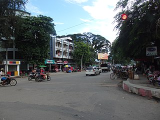
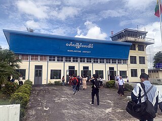
Lashio is the largest town in northern Shan State, Myanmar, about 200 kilometres (120 mi) north-east of Mandalay. It is situated on a low mountain spur overlooking the valley of the Yaw River. Loi Leng, the highest mountain of the Shan Hills, is located 45 km (28 mi) to the south-east of Lashio.
Myitkyina is the capital city of Kachin State in Myanmar (Burma), located 1,480 kilometers (920 mi) from Yangon, and 785 kilometers (488 mi) from Mandalay. In Burmese it means "near the big river", and Myitkyina is on the west bank of the Ayeyarwady River, just below 40 kilometers (25 mi) from Myit-son of its two headstreams. It is the northernmost river port and railway terminus in Myanmar. The city is served by Myitkyina Airport.

Air Bagan Limited was an airline headquartered in Bahan Township, Yangon, Myanmar. It operated domestic scheduled services within Myanmar, as well as to Thailand. Its main bases were Yangon International Airport and Mandalay International Airport.

Battle of Northern Burma and Western Yunnan was the name of the Chinese campaign with their allies in the 1943–45 Burma Campaign. The campaign ended in an Allied victory.

The Myanmar Air Force, known until 1989 as the Burmese Air Force, is the aerial branch of Myanmar's armed forces, the Tatmadaw. The primary mission of the Myanmar Air Force (MAF) since its inception has been to provide transport, logistical, and close air support to the Myanmar Army in counter-insurgency operations. It is mainly used in internal conflicts in Myanmar, and, on a smaller scale, in relief missions, especially after the deadly Cyclone Nargis of May 2008.
Mawlamyine Airport is an airport in Mawlamyine (Moulmein), Myanmar.
Thandwe Airport is an airport serving Thandwe, a town in the Rakhine State of Myanmar. The IATA code is based on the town's name during British colonial rule, Sandoway. On 23 June 2024, the Arakha Army captured the airport.
Myanmar National Airlines, formerly Union of Burma Airways, Burma Airways, and Myanma Airways, is a state-owned airline and the flag carrier of Myanmar, based in Yangon. Founded in 1948, the airline operates scheduled services to all major domestic destinations and to regional destinations in Asia. Its main base is Yangon International Airport.

Muse is the capital of Mu Se Township in northern Shan State, Myanmar. It is a border town situated on the Shweli River, and is connected by a bridge to Ruili in Yunnan Province, China. The town is a major regional trade hub with China, accounting for 70% of cross-border trade between the two nations.

Nawnghkio, variously spelt Naunghkio, Naungcho or Nawngcho, is a town in Kyaukme District, in northern Shan State, Burma. It is the principal town and administrative seat of Nawnghkio Township. It is connected to Mandalay, Pyin U Lwin, Kyaukme, Hsipaw and Lashio by road and rail and by road to Taunggyi via National Road 43. Asia World Company won the contract to rebuild part of the road in 2002. Originally on the Mandalay-Lashio Road, after Pyin U Lwin and before Kyaukme, Nawnghkio is on what is now the Mandalay-Muse Road, part of the Asian Highway Route 14 (AH14).

Kyaukme is a town in northern Shan State of Burma. It is situated on the Mandalay - Lashio road, after Pyin Oo Lwin and Nawnghkio, and before Hsipaw, on what is now the Mandalay - Muse road, part of the Asian Highway route 14 (AH14). It is also connected to Momeik (Mongmit) in the Shweli River valley and Mogok with its ruby mines. Kyaukme can be reached by train on the Mandalay-Lashio railway line. As of 2014, the population was 39,930.
Momeik, also known as Mong Mit in Shan, is a town situated on the Shweli River in northern Shan State. It is the principal town of Mongmit Township, Myanmar.
Laukkai is the capital of Kokang Self-Administered Zone in the northern part of Shan State, Myanmar. It is located east of the Salween River, which forms part of Myanmar's border with the People's Republic of China at its upper reaches. It is about 10 miles (16 km) away from Nansan, China. In Laukkai, Southwestern Mandarin and Chinese characters are widely used, and the Chinese renminbi is in circulation. It is the main town of Laukkaing Township of the Kokang Self-Administered Zone. It is 117 miles (188 km) from Lashio and 42 miles (68 km) from Kongyan. Its population is 23,435. Laukkai is notorious for its gambling, prostitution, human trafficking and online scams.
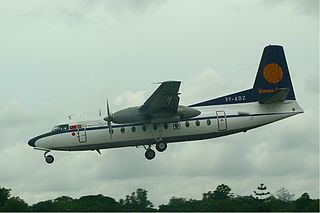
Myanma Airways Flight 635 was a scheduled domestic passenger flight from Yangon to Tachileik in eastern Myanmar that was operated by a Fokker F-27 Friendship owned by Myanmar's flag carrier Myanma Airways. On 24 August 1998, during its descent to Tachileik the flight went missing over a hill approximately two miles (3.2 km) from the airport. Search and rescue team later found the wreckage of the aircraft. The accident killed all 36 passengers and crew.
Asian Wings Airways was an airline based in Myanmar. It began service on 27 January 2011. It offered regular flights to all major tourist destinations in Myanmar.

The Myanmar National Democratic Alliance Army (MNDAA) is an armed resistance group in the Kokang region of Myanmar (Burma). The army has existed since 1989, having been the first one to sign a ceasefire agreement with the Burmese government. The ceasefire lasted for about two decades.

Duwa Lashi La is a Burmese politician and lawyer of Kachin descent and the president of the Kachin National Consultative Council.

The Myanmar Civil War, also called the Burmese Spring Revolution, Burmese Civil War or People's Defensive War, is an ongoing civil war following Myanmar's long-running insurgencies, which escalated significantly in response to the 2021 military coup d'état and the subsequent violent crackdown on anti-coup protests. The exiled National Unity Government and major ethnic armed organisations repudiated the 2008 Constitution and called instead for a democratic federal state. Besides engaging this alliance, the SAC also contends with other anti-SAC forces in areas under its control. Hannah Beech of The New York Times observed the insurgents are apportioned into hundreds of armed groups scattered across the country.

The Battle of Lashio was an offensive conducted by the Three Brotherhood Alliance, along with other resistance forces, to capture the northern Shan city of Lashio. The headquarters for the Tatmadaw's Northeastern Command, the city was besieged by rebel forces following the collapse of the Chinese-mediated ceasefire that had paused the rebels' Operation 1027.

