Kalay (Burmese : ကလေး), also known as Kale, is a town in the Sagaing Region of Myanmar. It is located upstream from Mandalay and Monywa on the Myittha River, a tributary of the Chindwin River. The town is the district headquarters of the Kalay District. [1] It has gained importance with trans border movement enabled between Myanmar and India following the 165 kilometres (103 mi) Tamu–Kalay section of India–Myanmar–Thailand Trilateral Highway built by the Border Roads Organization of India under the Look-East Connectivity policy. [2] Consequently, Kalay is now one of the fastest developing towns in Myanmar.
Kalay has several notable prisons, to which people from all across the region are transported. [3]
The earlier name of the town ‘Karlaymyo,’ renamed now as ‘Kalaymyo,’ means “a town surrounded by four satellite towns” in the Burmese language. "Kalaymyo" means "town of children" in Burmese.
According to tradition, Kalay was established as a town on 3 February 966 (Sunday, the 5th of waning of Tabodwe 328 ME). [1] A votive tablet unearthed in Kalay in 1983, with a Mon language by ညောင်ဦး စောရဟန်း the first ruler was his son, the inscription, refers to the "Aniruddha, the Great King". [4] [5]
During the Second World War, Kalay was an important regrouping point for the British during their retreat from Burma in 1942 because of the relatively easier access to India along the Manipur River (the alternative was to march through malarial forests from Kalewa to Tamu). [6]
On September 19, 2007, 200 monks marched through the streets of Kalay as a part of the 2007 Burmese anti-government protests. Over the next few days, the monks were joined by thousands of people of the Chin ethnic group. On September 24, students marched from Kalay University with posters and protested, demanding the release of Aung San Suu Kyi and two other political prisoners. [7]
In July 2015, a monsoon rain triggered a natural disaster, and a state of emergency was declared in four regions of the country. The disaster caused a flash flood in Kalay and surrounding areas. Kalay was devastated by the disaster.
(He has one daughter Sao Thiri Mala born from Mahadewi Sao Hkam Long and one son Hso Hkaing Hpa and one daughter Sao Ke Youn born from Sao Hkam Loun, both his wives were Hso Hkawng Hpa's daughters, Hso Hkaing Hpa died of smallpox, and his two daughters married Hso Kert Hpa the son of Sao Hkun Mawng from Hsipaw)
Geographically, the distinctive feature of the town is that the Tropic of Cancer passes through it. This point has been marked by the milepost 55/56 near Kyansitgon village. Set in terrain that has an average elevation of 450 feet (140 m) above mean sea level, the town has a picturesque backdrop of the Laytha Hill in the east and the Chin Hills in the west. [1]
The city is drained by the Myittha River that flows in a south–north direction, the Nayyinzaya River that flows in a north–south direction, and the Manipura River (also called the Nunkathe River) from across the international border with India; the last-named river has its origin in Manipur state of the north-east India. [1]
A tropical savanna climate (Köppen Aw) dominates the town. Temperature variations are significant, with summer months from March to May recording 100–112 °F (38–44 °C) and the winter months in the range of 55–80 °F (13–27 °C). The average annual temperature is reported to be 79 °F (26 °C). The average annual rainfall is of the order of 67.77 inches (172.1 cm). [1]
Climate data for Kalay (1991–2020) | |||||||||||||
---|---|---|---|---|---|---|---|---|---|---|---|---|---|
Month | Jan | Feb | Mar | Apr | May | Jun | Jul | Aug | Sep | Oct | Nov | Dec | Year |
Record high °C (°F) | 32.5 (90.5) | 38.8 (101.8) | 42.1 (107.8) | 42.6 (108.7) | 43.7 (110.7) | 39.0 (102.2) | 38.6 (101.5) | 38.5 (101.3) | 37.3 (99.1) | 36.0 (96.8) | 33.8 (92.8) | 31.6 (88.9) | 43.7 (110.7) |
Mean daily maximum °C (°F) | 25.9 (78.6) | 29.8 (85.6) | 34.6 (94.3) | 37.3 (99.1) | 36.0 (96.8) | 33.6 (92.5) | 32.7 (90.9) | 32.2 (90.0) | 31.9 (89.4) | 31.1 (88.0) | 28.6 (83.5) | 25.6 (78.1) | 31.6 (88.9) |
Daily mean °C (°F) | 19.5 (67.1) | 22.2 (72.0) | 26.1 (79.0) | 29.6 (85.3) | 30.1 (86.2) | 29.3 (84.7) | 28.9 (84.0) | 28.5 (83.3) | 28.0 (82.4) | 26.9 (80.4) | 23.7 (74.7) | 20.2 (68.4) | 26.1 (79.0) |
Mean daily minimum °C (°F) | 13.2 (55.8) | 14.5 (58.1) | 17.6 (63.7) | 21.9 (71.4) | 24.2 (75.6) | 25.0 (77.0) | 25.0 (77.0) | 24.8 (76.6) | 24.1 (75.4) | 22.7 (72.9) | 18.9 (66.0) | 14.8 (58.6) | 20.6 (69.1) |
Record low °C (°F) | 6.0 (42.8) | 6.7 (44.1) | 8.6 (47.5) | 14.7 (58.5) | 18.8 (65.8) | 22.0 (71.6) | 23.0 (73.4) | 22.6 (72.7) | 20.5 (68.9) | 17.7 (63.9) | 11.5 (52.7) | 9.1 (48.4) | 6.0 (42.8) |
Average precipitation mm (inches) | 4.4 (0.17) | 3.7 (0.15) | 12.2 (0.48) | 31.9 (1.26) | 162.8 (6.41) | 244.7 (9.63) | 272.6 (10.73) | 292.2 (11.50) | 333.2 (13.12) | 210.1 (8.27) | 27.9 (1.10) | 4.9 (0.19) | 1,600.7 (63.02) |
Average precipitation days (≥ 1.0 mm) | 0.6 | 0.7 | 1.6 | 4.1 | 10.8 | 15.8 | 18.0 | 18.2 | 14.8 | 11.0 | 3.0 | 1.0 | 99.7 |
Source 1: World Meteorological Organization [8] | |||||||||||||
Source 2: Norwegian Meteorological Institute (extremes) [9] |
The population of Kalay is estimated to be 400,000, comprising 55% Bamar, 35% Chin and 10% other nationalities and foreigners. [1] The valley town, with its tranquil atmosphere, is inhabited in equal numbers by the Chin community and Bamars. The original settlers are Shans. [10]
The economy of Kalay is dependent upon agriculture but it is also an industrial town. Cars, jeeps, trucks, fire engines, trailers, three-wheeled motorcycles are manufactured in the Kalay Industrial Estate. The town is the hub of trading activity with India across the border. [1]
Kalay Township is unable to meet its own food requirements, although it exports food to neighbouring towns and cities. It has 80,000 acres (32,000 ha) under paddy, 10,000 acres (4,000 ha) under peas, and 40,000 acres (16,000 ha) under cooking oil crops. The irrigation dam in RāZāJo village will provide water to grow more crops under irrigated conditions. [1]
Kalay Township has teak, ironwood ( Pterocarpus indicus ), the large timber tree Shorea obtusa , Shorea robusta and many other species of tree. [1]
The religious composition of Kalay and the surrounding township is listed as 35 percent Buddhists (mainly Theravada Buddhists), 70 percent Christian (mainly Baptist) and the remaining 5 percent follow other religious practices. The district has 116 Buddhist monasteries, 508 churches, a mosque, two Hindu temples, two Buddhist seminaries for nuns, five Buddhist nunneries and a joss house (Chinese communal temple ). [1]
The basic social services of education (primary to high school level, and universities within close commutable distances from the town), health services (general hospital, military hospital and traditional medicines' hospital), modern telecommunication network (telephone, Internet, telecommunication satellite network etc.), Media network of news papers (simultaneous coverage of news with Yangon), TV and radio services are well established in the town. The town's electricity needs are met from the MāNePu Hydroelectric Project, which also helps promote industries. [1]
The strategic road between India and Myanmar, built with assistance from the Government of India, is the 165 kilometres (103 mi) Tamu–Kalay road. The Border Roads Organization, a parastatal organization of the Government of India, started construction of this road in 1997, which was opened by the Foreign Minister of India in 2001. This road has facilitated trans-border movement between India and Myanmar. [2] Apart from this road, the town is well connected by a network of roads with Kalay, Gangaw, Monywa, Yagyi and Mandalay. The important road route during the rainy season is the Kalay-Gangaw-Monywa-Mandalay road and during winter it is the Kalay-Myoma-Yagyi-Monywa-Mandalay Route. [1]
Rail services also operate between Kalay and Gangaw. This line passes through the Pountaung Pounyar Tunnel. [1]
Inland water transport is also available up to Kalaywa, which is 24 kilometres (15 mi) short of Kalay. On this route, Morlike, Homalin, Khunte, Mingin and Monywar are also accessible. [1]
There is an airport at Kalay, an extension of a British-built Second World War airstrip that was used to ferry troops and supplies into Myanmar during the British reconquest of Myanmar in 1945. The airport is located in the middle of the town. Myanmar National Airlines, Air Bagan, Air Mandalay and Air KBZ operate regular air services to and from Yangon, Mandalay and Kalaymyo. [1] [6] The airport is at an elevation of 499 feet (152 m); it has a 79 metres (259 ft) wide and 1,677 metres (5,502 ft) long runway with blacktopped surface. [11] [12]
Magway Region is an administrative division in central Myanmar. It is the second largest of Myanmar's seven divisions, with an area of 44,820 km2. Pa Del Dam (ပဒဲဆည်) is one of the dams in Aunglan Township, Magway Division. The capital and second largest city of the Magway Division is Magway. The largest city is Pakokku. The major cities of Magway Division are Magway, Pakokku, Aunglan, Yenangyaung, Taungdwingyi, Chauk, Minbu, Thayet and Gangaw.
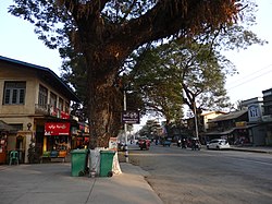
Pakokku is the largest city in the Magway Region of Myanmar. It is situated about 30 km northeast of Bagan on the Irrawaddy River. It is the administration seat of Pakokku Township, Pakokku District and Gangaw District. Pakokku Bridge is part of the India–Myanmar–Thailand Trilateral Highway and is the longest bridge in Myanmar. It is home of the Pakokku Airport.
Wuntho or Waing Hso was a native state of Upper Burma when Burma (Myanmar), was under British control. It had an area of around 6,200 square kilometres (2,400 sq mi) with 150,000 inhabitants and lay midway between the Ayeyarwady River and Chindwin Rivers.
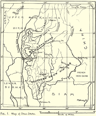
Laihka State, also spelt Legya or Lecha, was a state in the central division of the Southern Shan States of Burma, with an area of 3,711 square kilometres (1,433 sq mi).
Gangaw is a town of Gangaw Township in Gangaw District in the Magway Division in Myanmar. Gangaw is also known as the City of Yaw, a certain region in Myanmar including Gangaw (ဂန့်ဂေါ), Tilin (ထီးလင်း), Saw (ဆော) and villages around them. Gangaw District and Gangaw township was a part of Pakokku District until 2003.In 2003,Gangaw District was established. Myit Thar river (မြစ်သာမြစ်) flows from South to North dividing the town into Gangaw and Western Gangaw (အနောက်ဂန့်ဂေါ) village.
Yawnghwe, known as Nyaungshwe in Burmese, was a Shan state in what is today Myanmar. It was one of the most important of the Southern Shan States. Yawnghwe state included the Inle Lake. The administrative capital was Taunggyi, located in the northern part of the state. The Agent of the British government, the Superintendent of the Southern Shan States, resided at Taunggyi and the king's palace was at Yawnghwe.
Muang Mao, also spelled MöngMao or the Mao Kingdom, was an ethnic Dai state that controlled several smaller Tai states or chieftainships along the frontier of what is now Myanmar, China, the states of Northeast India of Assam, Nagaland, Manipur and Arunachal Pradesh principally set in the Dehong region of Yunnan with a capital near the modern-day border town of Ruili/Meng Mao. The name of the main river in this region is the Nam Mao, also known as the Shweli River.
Longchuan County is a county located in Dehong Prefecture, Yunnan province, southwestern China.
Mandalay Central railway station, located in downtown Mandalay, is one of the largest rail stations in Myanmar. The station is Upper Myanmar's gateway to the 3,126-mile (5,031 km) national rail network. It is the terminus of the main rail line from Yangon and the starting point of branch lines to Pyin U Lwin (Maymyo), Lashio, Monywa, Pakokku, Kalay, Gangaw, and to the north, Shwebo, Kawlin, Naba, Kanbalu, Mohnyin, Hopin, Mogaung and Myitkyina.
Kale District is the westernmost district in Sagaing Division of Myanmar (Burma).
Hsipaw, also known as Thibaw, is the principal town of Hsipaw Township in Shan State, Myanmar on the banks of the Duthawadi River. It is 200 kilometres (120 mi) north-east of Mandalay.
Mongmit or Möngmit, also known as Momeik, was a Shan state in the Northern Shan States in what is today Burma. The capital was Mongmit town. The state included the townships of Mongmit and Kodaung.
Lawksawk, also known as Yatsawk was a Shan state in what is today Burma. It was located north of Myelat and belonged to the Central Division of the Southern Shan States. Its capital was Lawksawk town. The state included 397 villages and the population was mostly Shan, but there were also Danu, Pa-O and Palaung people in the area.
Mongpai, also known as Mobye, was a Shan state in what is today Burma. It belonged to the Central Division of the Southern Shan States. Mongpai was based in the modern town of Mobye.
The Kingdom of Pong or Pong Kingdom was an ethnically Tai state that controlled several smaller states along the frontier of what is now Myanmar, China and Northeast Indian states of Assam, Manipur, Nagaland and Arunachal Pradesh.
Hsawnghsup was one of the outlying Shan princely states in what is today Burma.
Mogaung or Möngkawng was a Shan state in what is present-day Myanmar. It was an outlying territory, located away from the main Shan State area in present-day Kachin State. The state existed until 1796. The main town was Mogaung.
Wanmaw, Manmaw or Banmaw (Bhamo) was a Shan state in what is today Burma. It was an outlying territory, located away from the main Shan State area in present-day Kachin State close to the border with China.
Pakokku–Kalay Railway is a railway line operated by Myanma Railways under the Ministry of Transport and Communications. This railway connects towns on the western bank of the Ayeyarwady River, such as Pakokku, Myaing, Gangaw, and Kalay. The railway spans a total of 240.47 miles in distance, with a track length of 274.04 miles and includes 65 stations.
{{cite web}}
: CS1 maint: unfit URL (link) Data current as of October 2006. Source: DAFIF.