Sagaing District

Last updated
Sagaing District
Sagaing District.jpg
Sagaing District signboard located on Sagaing-Shwebo road
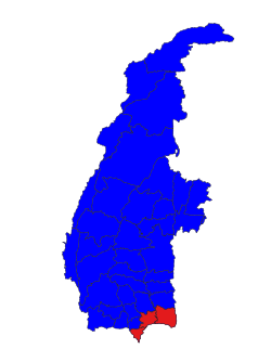
Country Flag of Myanmar.svg  Burma
Region Sagaing Region
No. of Townships 3
Capital Sagaing
Time zone UTC+6.30 (MST)

Sagaing District is an administrative district in southern Sagaing Division, Burma (Myanmar). [1] Its administrative center is the city of Sagaing.

Townships

Townships of Sagaing district Sagaing district.svg
Townships of Sagaing district


  Sagaing
  Myinmu
  Myaung

Sagaing District consists of the following townships:

Notes

  1. "Burma: Second-Order Administrative Divisions (Districts)" The Permanent Committee of Geographic Names (PCGN), United Kingdom, from Internet Archive

Coordinates: 22°00′N95°37′E / 22.000°N 95.617°E / 22.000; 95.617

Related Research Articles

Magway Region Region of Myanmar

Magway Region is an administrative division in central Myanmar. It is the second largest of Myanmar's seven divisions, with an area of 44,820 km2. Pa Del Dam (ပဒဲဆည်) is one of the dams in Aunglan Township, Magway Division. The capital and second largest city of the Magway Division is Magway. The largest city is Pakokku. The major cities of Magway Division are Magway, Pakokku, Chauk, Aunglan, Yenangyaung, Taungdwingyi, Minbu, Thayet and Gangaw.

Chaung-U Town in Sagaing Region, Myanmar

Chaung-U is a town in central Myanmar. It is located in Monywa District, Sagaing Division. It is the principal town of Chaung-U township. In the Bagan dynasty, when King Popa Saw Rahan governed the country, it was named "San Tauk Village". It was a large village where different natives of the Union of Myanmar, like Kayin, Shan and Lawah (Wah) natives, lived happily together. Then, King Kyansit founded the city, gathering ten villages together, for example, Ywa Thit and Ywa Ma, naming it Chaung-U. It is situated 231.46 feet (70.55 m) above sea level at north latitude 21° 57' and east longitude 95° 8' to 95° 25'. The Monywa–Mandalay highway road passes it, so the communication to it is good, quick and easy. The Monywa–Mandalay railway meets that of Chaung-U–Pakokku in the town's station, so it is possible to get there by train. Its official township boundary touches the boundaries of other townships: Myinmu is in the east, Myaung is in the south and south-east, Salingyi is in the west, and Monywa is in the north. The Chindwin River is in the west of the township and the town is six miles away from the river. In Chaung-U there are historical ancient pagodas. Besides, its township has other historical villages, streams, and hills.

Bhamo District

Bhamo District is a district of the Kachin State in northern Burma (Myanmar). The capital is the city of Bhamo. The district covers an area of 10,742.9 km2. In 2002, the population of the Bhamo District was an estimated 363,300. The district consists of four townships:

Hpakant Township Township in Kachin State, Burma

Hpakant Township is a township of Mohnyin District in the Kachin State of Burma (Myanmar). The administrative centre is Hpakant. The major town is Kamaing.

Myinmu Town in Sagaing Region, Myanmar

Myinmu is a river town in the south-east of the Sagaing Division in Burma. The town has a rich history linked to World War II during the Burma Campaign against the Japanese, in 1944. It was also under the control of the Portuguese Missionaries in the 19th century. One of the first agricultural cooperatives was established here in 1905.

Myaung is a town in the Sagaing Region in central Myanmar. It is a crowded and peaceful town where is located on the west bank of the Ayeyarwady River. It is a region between the Rivers of Ayeyarwady and Chindwin. There are many ancient and historical pagodas, monasteries, and places in Myaung Township. Myaung Township is officially demarcated with the neighbour boundaries of Chaung-U in the north-west, of Myinmu in the east and north east. In the township of Myaung, Kyauk Nagar Mountain is very famous, where very ancient rocky statues like the rocky dragon-shaped statues are found, and the Buddhist Region rich of many pagodas is situated. Myaung Township is one of the townships which were historically concerned with King Kyansit like Chaung-U Township. There are also many pagodas or Buddhist temples and monasteries of or built by King Kyansittha at the age of Bagan. It is a crowded town since it is located on the west bank of the river. To get there, there is Myaung-Payeinma Road, turning in from the Monywa-Mandalay one.

Kanbalu is a town in Shwebo District, Sagaing Division, in Myanmar. It is the administrative seat for Kanbalu Township. Kanbalu is on the main Burmese north-south railroad between Sagaing and Myitkyina. As of 2014, it had a population of 25,022

Katha District is the northeasternmost district in Sagaing Region of Myanmar. Its administrative center is the town of Katha.

Shwebo District District in Sagaing Region, Burma

Shwebo District is a district in south-central Sagaing Division of Burma (Myanmar). Its administrative center is the city of Shwebo.

Kale District District in Sagaing Region, Burma

Kale District is the westernmost district in Sagaing Division of Myanmar (Burma).

Monywa District District in Sagaing Region, Burma

Monywa District is an administrative district in southern Sagaing Division, Burma (Myanmar). Its administrative center is the city of Monywa.

Tamu District or Tuimu District is an administrative district in Sagaing Division, Burma (Myanmar). Its administrative center is Tamu Town.

Myinmu Township Township in Sagaing Region, Burma

Myinmu Township is a township in the southeast of the Sagaing Division in Burma (Myanmar), west of Mandalay. The principal town is Myinmu which lies on the northern bank of the Irrawaddy River. History of Myinmu is closely linked to the World War II against the Japanese Army when British General Sir Douglas Gracey occupied the town after crossing the Irrawaddy River.

Paledan Village in Sagaing Region, Burma

Paledan is a village in Myinmu Township in the southeast of the Sagaing Division in Burma. It is located just east of Myinmu on the northern bank of the Irrawaddy River.

Allagappa Town in Sagaing Region, Burma

Allagappa is a small town in Myinmu Township in the southeast of the Sagaing Division in Burma. It is located west of Myinmu, near the northern bank of the Irrawaddy River. It lies in the Allagappa Valley, about 30 miles west of Sagaing city. It is connected by road to the main Monywa to Sagaing road and has a divisional medical centre. Allagappa was occupied in late January 1944 by the 100th Infantry Brigade of the British Indian Army during World War II.

Lingadipa Village in Sagaing Region, Burma

Lingadipa is a village in Myinmu Township in the southeast of the Sagaing Division in Burma. It is located west of Myinmu, near Allagappa on the northern bank of the Irrawaddy River. The village was occupied by the British Indian Army on 13–14 February 1944 during World War II.

Myaung Township Township in Sagaing Region, Burma

Myaung Township is a township in Sagaing District in the Sagaing Division of Burma.

Chaung-U Township Township in Sagaing Region, Burma

Chaung-U Township is a township in Monywa District of Sagaing Division in Burma. The principal town is Chaung-U.

Hmawbi Township Township in Yangon Region, Myanmar

Hmawbi Township is a township in the Yangon Region of Burma (Myanmar). It is located northwest of the city of Yangon. The principal town and administrative seat is Hmawbi. The Hmawbi airport is at Indan (Inntan), 4 kilometres (2.5 mi) northeast of the town of Hmawbi.

Aye Myat Mon is a Burmese politician who has been the MP of the Sagaing Region Hluttaw for Myaung Township No. 1 constituency since the 2015 general election. She is a member of the National League for Democracy.