Kalewa

Last updated
Kalewa
Town
Tahan, Burma.jpg
Myanmar adm location map.svg
Red pog.svg
Kalewa
Location of Kalewa within Myanmar
Coordinates: 23°12′48″N94°19′06″E / 23.21333°N 94.31833°E / 23.21333; 94.31833 Coordinates: 23°12′48″N94°19′06″E / 23.21333°N 94.31833°E / 23.21333; 94.31833
Country Flag of Myanmar.svg  Myanmar
Division Flag of Sagaing Region (2019).svg  Sagaing Region
District Kale
Township Kale Township
Time zone UTC+06:30 (MST)

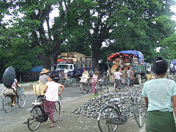
Kalewa is a town at the confluence of the Chindwin River and the Myittha River in Kale District, Sagaing Region of north-western Myanmar. It is the administrative seat of Kalewa Township.

Contents

Climate

Kalewa has a tropical savanna climate (Köppen climate classification Aw). Temperatures are very warm throughout the year, although the winter months (December–February) are milder. The pre-monsoon months from March to May are especially hot, with maximum temperatures around 35 °C (95 °F). There is a winter dry season (November–April) and a summer wet season (May–October).

Climate data for Kalewa (1981–2010)
MonthJanFebMarAprMayJunJulAugSepOctNovDecYear
Record high °C (°F)30.8
(87.4)
37.2
(99.0)
41.8
(107.2)
43.4
(110.1)
45.0
(113.0)
42.8
(109.0)
38.9
(102.0)
37.2
(99.0)
35.6
(96.1)
35.1
(95.2)
32.8
(91.0)
30.1
(86.2)
45.0
(113.0)
Average high °C (°F)25.6
(78.1)
29.2
(84.6)
33.9
(93.0)
36.5
(97.7)
35.7
(96.3)
32.9
(91.2)
32.5
(90.5)
31.9
(89.4)
31.5
(88.7)
30.9
(87.6)
27.9
(82.2)
25.0
(77.0)
31.1
(88.0)
Average low °C (°F)13.3
(55.9)
14.4
(57.9)
17.9
(64.2)
22.1
(71.8)
24.2
(75.6)
25.0
(77.0)
25.0
(77.0)
24.8
(76.6)
24.1
(75.4)
22.9
(73.2)
19.1
(66.4)
14.9
(58.8)
20.6
(69.1)
Record low °C (°F)9.4
(48.9)
9.5
(49.1)
10.0
(50.0)
15.6
(60.1)
15.5
(59.9)
21.8
(71.2)
22.4
(72.3)
20.8
(69.4)
21.5
(70.7)
18.6
(65.5)
13.4
(56.1)
10.7
(51.3)
9.4
(48.9)
Average rainfall mm (inches)2.9
(0.11)
4.0
(0.16)
17.3
(0.68)
37.6
(1.48)
182.0
(7.17)
272.1
(10.71)
245.6
(9.67)
303.3
(11.94)
346.3
(13.63)
187.5
(7.38)
38.7
(1.52)
4.0
(0.16)
1,641.3
(64.62)
Source: Norwegian Meteorological Institute [1]

Economy

Upstream from Mandalay and Monywa on the Chindwin River, Kalewa is gaining importance as a staging point for trade between Burma and India.

Mdy Shop.JPG

See also

Related Research Articles

Interior Alaska Geographic region

Interior Alaska is the central region of Alaska's territory, roughly bounded by the Alaska Range to the south and the Brooks Range to the north. It is largely wilderness. Mountains include Denali in the Alaska Range, the Wrangell Mountains, and the Ray Mountains. The native people of the interior are Alaskan Athabaskans. The largest city in the interior is Fairbanks, Alaska's second-largest city, in the Tanana Valley. Other towns include North Pole, just southeast of Fairbanks, Eagle, Tok, Glennallen, Delta Junction, Nenana, Anderson, Healy and Cantwell. The interior region has an estimated population of 113,154.

Geography of Myanmar

Myanmar is the northwesternmost country of mainland Southeast Asia. It lies along the Indian and Eurasian Plates, to the southeast of the Himalayas. To its west is the Bay of Bengal and to its south is the Andaman Sea. It is strategically located near major Indian Ocean shipping lanes. The neighboring countries are China, India, Bangladesh, Thailand and Laos.

Mizoram State in Northeast India

Mizoram is a state in northeastern India, with Aizawl as its capital city. The name is derived from "Mizo", the name of the native inhabitants, and "Ram", which means land, and thus Mizoram means "land of the Mizos". Within the northeast region, it is the southernmost landlocked state, sharing borders with three of the Seven Sister States, namely Tripura, Assam and Manipur. The state also shares a 722-kilometre border with the neighbouring countries of Bangladesh and Myanmar.

Northeast India Group of Northeastern Indian states

Northeast India is the easternmost region of India representing both a geographic and political administrative division of the country. It comprises eight states – Arunachal Pradesh, Assam, Manipur, Meghalaya, Mizoram, Nagaland, Sikkim and Tripura. The region shares an international border of 5,182 kilometres (3,220 mi) with several neighbouring countries – 1,395 kilometres (867 mi) with Tibet Autonomous Region, China in the north, 1,640 kilometres (1,020 mi) with Myanmar in the east, 1,596 kilometres (992 mi) with Bangladesh in the south-west, 97 kilometres (60 mi) with Nepal in the west, and 455 kilometres (283 mi) with Bhutan in the north-west. It comprises an area of 262,230 square kilometres (101,250 sq mi), almost 8 percent of that of India, and is one of the largest salients (panhandles) in the world.

Climate of India Climatic conditions of India

The climate of India comprises a wide range of weather conditions across a vast geographic scale and varied topography, making generalizations difficult. Climate in north India is generally hotter than south India whereas the South India gets more humid due to nearby coasts. Most parts of the nation don't experience temperatures below 10 °C (50 °F) in winter, and the temperature usually tends to exceed 40 °C (104 °F) during summer. Based on the Köppen system, India hosts six major climatic sub types, ranging from arid deserts in the west, alpine tundra and glaciers in the north, and humid tropical regions supporting rain forests in the southwest and the island territories. Many regions have starkly different microclimates, making it one of the most climatically diverse countries in the world. The country's meteorological department follows the international standard of four seasons with some local adjustments: winter, summer, monsoon (rainy) season, and a post-monsoon period.

Monywa City in Sagaing Region, Myanmar

Monywa is the largest city in Sagaing Region, Myanmar, located 136 km north-west of Mandalay on the eastern bank of the River Chindwin.Monywa is one of the largest economic cities in Myanmar.

Chindwin River

The Chindwin River is a river flowing entirely in Myanmar, and the largest tributary of the country's main river, the Ayeyarwady.Its official name is also spelled Chindwinn.

Bhamo Place in Kachin State, Myanmar

Bhamo is a city in Kachin State in northern Myanmar, 186 km (116 mi) south of the state capital, (Myitkyina). It is on the Ayeyarwady River. It lies within 65 km (40 mi) of the border with Yunnan Province, China. The population consists of Chinese and Shan, with Kachin peoples in the hills around the town. It is the administrative center of Bhamo District and Bhamo Township.

History of Mizoram

The history of Mizoram basically encompasses the history of Mizoram which lies in the remotest part of northeast India. It is a conglomerate history of several ethnic groups of Chin people who migrated from Chin State of Burma. But information of their patterns of westward migration are based on oral history and archaeological inferences, hence nothing definite can be said. The recorded history started relatively recently around the mid-19th century when the adjoining regions were occupied by the British monarchy. The land is now inhabited by a mixture of people from Chin Hills and Bangladesh and its history is therefore largely reflected by those of Lusei, Hmar, Lai, Mara and Chakmas tribes. Following religious, political and cultural revolutions in the mid-20th century majority of the people agglomerated into a super tribe, Mizo. Hence the officially recognised settlement of the Mizos became Mizoram.

Ukhrul district District of Manipur in India

Ukhrul District is an administrative district of the state of Manipur in India with its headquarters at Ukhrul, that is Hunphun. The district occupies the north-eastern corner of the state and it extends between latitudes of 24° 29′ and 25° 42′ N and longitudes 94° 30′ and 94° 45′ E approximately. It shares an international boundary with Myanmar (Burma) on its eastern side and is bounded by Nagaland state in the north, Senapati district and Kangpokpi district in the west and Kamjong district in the south. It has the distinction of being the highest hill station of Manipur. The terrain of the district is hilly with a varying heights of 913 m to 3114 m (MSL). Ukhrul, the district HQ., at an altitude of 2020 m (MSL) is linked with Imphal, the state capital by NH 202 which is about 84 kilometres apart. The district covers an area of 4,544 square kilometres including Kamjong district making it the second largest district of the state after Churachandpur district and has a population of almost 1,83,998 according to Census of India 2011 comprising about 6.44 per cent of the total state population.The Tangkhul Naga tribe constitute the major bulk of the population with other communities such as Kukis, Nepalese and other non-tribals constituting a small percentage of the district population. Administratively, the district which comprises around 200 villages was divided into five sub-divisions, where their boundaries were coterminous with that of the Tribal Development Blocks. There was no statutory town in the district except one census town which was formed in 2011 Census. Recently, Kamjong district was carved out from Ukhrul District as a separate district. Ukhrul District has three assembly constituencies before the bifurcation of the district which are Phungyar Assembly Constituency (43-ST), Ukhrul Assembly Constituency (44-ST) and Chingai Assembly Constituency. The district is best introduced by its rare and beautiful Shirui Lily, , which has achieved international fame because of its uniqueness. Also, the district has provided two of Manipur's chief ministers and the only from amongst the hill districts of Manipur, Yangmaso Shaiza the first tribal chief minister of Manipur and Rishang Keishing who is also the first MP from Outer Manipur. William Pettigrew (missionary), an educationist and a Scottish-British Christian Missionary pioneered the western system of education and introduced the Christianity faith among the Tangkhal Naga tribe. Phungyo Baptist Church, Tangrei, Ukhrul, the oldest and the first Christian church of Manipur which still stands today is a testament to his passion for missionary work.

Homalin Town in Sagaing Region, Myanmar

Homalin or Hommalinn is a small town in north-western Burma and capital of the Homalin Township in Hkamti District of the Sagaing Region. The town lies on the Chindwin River and is served by Homalin Airport.

Ye, Mon State Town in Mon State, Myanmar

Ye is a town in the southern end of Mon State, Myanmar (Burma). It is the principal town of Ye Township of Mawlamyine District. The town is located by the Ye River as it drains into the Gulf of Martaban, and is surrounded by Tenasserim Hills in the east. It has warm, moderate weather. The town's economy is mainly based on betel nut, rubber, fishery production, and trade. Ye is on the Mawlamyaing-Dawei rail line, and has a seaport. The majority of the people are ethnic Mon people. Ye is a center of Mon language education.

Lawngtlai district District of Mizoram in India

Lawngtlai district is one of the eleven districts of Mizoram state in India. The district is bounded on the north by Lunglei district, on the west by Bangladesh, on the south by Myanmar and on the east by Saiha district. The district occupies an area of 2557.10 km2. Lawngtlai town is the administrative headquarters of the district.

Kalay Town in Sagaing Region, Myanmar

Kalay, also known as Kale, is a town in the Sagaing Region of Myanmar. It is located upstream from Mandalay and Monywa on the Myittha River, a tributary of the Chindwin River. The town is the district headquarters of the Kalay District. It has gained importance with trans border movement enabled between Myanmar and India following the 165 kilometres (103 mi) Tamu–Kalay section of India–Myanmar–Thailand Trilateral Highway built by the Border Roads Organization of India under the Look-East Connectivity policy. Consequently, Kalay is now one of the fastest developing towns in Myanmar.

Climate of Vietnam

Vietnam's climate, because its in the tropics and strongly influenced by the South China Sea, has a monsoon-influenced tropical climate typical of that of mainland Southeast Asia. In the north, the climate is monsoonal with four distinct seasons while in the south, the climate is tropical monsoon with two seasons. In addition, a temperate climate exists in mountainous areas, which are found in Sa Pa and Da Lat, while a more continental climate exists in Lai Chau Province and Son La Province.

The Daai are an ethnic group living in Chin State, Myanmar. The Daai consist of 32 Chin tribes, which have been registered by the Government of Burma since 1890. The recent Military Regime’s census mentions the Daai tribe as the 62nd of 135 tribes of Burma. Researchers refer to them as the Daai group in the ethnic survey book of Burma. The Daai Chin appear to be of Mongolian, Indo-Chinese, and Tibeto-Burman descent. The Daai people live in the Mindat, Paletwa, Matupi and Kanpetlet townships of Southern Chin State in Burma. There are more than 180 Daai villages with a total population of somewhere between 40,000 and 50,000. Their population makes the Daai-Chin the majority tribe of the Southern Chin Hills.

Zogam

Zogam known as Zoland, Lushai Hills, Kuki Hills, lies in the northwest corner of the Mainland Southeast Asia landmass. This is the traditional ancestry homeland of the Zo people or Zomi who lived in this area before the colonial period under British rulership.

Homalin Township Township in Sagaing Region, Burma

Homalin Township is a township in Hkamti District in the Sagaing Region of Burma. The principal town is Homalin. The principal rivers flowing through the township are the Chindwin River form north to south and the Uyu River from east to west, joining the Chindwin near Homalin town.

Ranglong language is a Kuki-Chin language of India and Burma. It is also recorded as Langrong by UNESCO and declared as critically endangered language.

Hill tribes of Northeast India

The hill tribes of Northeast India are hill people, mostly classified as Scheduled Tribes (STs), who live in the Northeast India region. This region has the largest proportion of scheduled tribes in the country.

References

  1. "Myanmar Climate Report" (PDF). Norwegian Meteorological Institute. pp. 23–36. Archived from the original (PDF) on 8 October 2018. Retrieved 28 October 2018.

See also