Pale Township is a township in Yinmabin District in the Sagaing Division of Myanmar. The principal town is Pale.
Yinmabin District is a newly created district in southern Sagaing Division, Burma (Myanmar); which was formerly part of Monywa District. Its administrative center is the city of Yinmabin.
Sagaing Region is an administrative region of Myanmar, located in the north-western part of the country between latitude 21° 30' north and longitude 94° 97' east. It is bordered by India’s Nagaland, Manipur, and Arunachal Pradesh States to the north, Kachin State, Shan State, and Mandalay Region to the east, Mandalay Region and Magway Region to the south, with the Ayeyarwady River forming a greater part of its eastern and also southern boundary, and Chin State and India to the west. The region has an area of 93,527 km2. In 1996, it had a population of over 5,300,000 while its population in 2012 was 6,600,000. The urban population in 2012 was 1,230,000 and the rural population was 5,360,000. The capital is Sagaing.
This page is based on this Wikipedia article Text is available under the CC BY-SA 4.0 license; additional terms may apply. Images, videos and audio are available under their respective licenses.
Related Research Articles
The Palaung or Ta'ang are a Mon–Khmer ethnic minority found in Shan State of Burma, Yunnan Province of China and Northern Thailand. In China, they are referred to as the De'ang people.
Articles related to Myanmar include:
Districts are the second-level administrative divisions of Myanmar. They are the sub-divisions of the States and Regions of Myanmar. According to the Myanmar Information Management Unit (MIMU), as of December 2015, there are 67 districts in Myanmar, which in turn are subdivided into townships, then towns, wards and villages.
Salingyi is a town in Salingyi Township, Monywa District, Sagaing Region in Myanmar. It is the administrative seat for Salingyi Township, and is at a tri-crossroads with roads heading north-west to Yinmabin, north to Monywa, and south-west to Kyadet. On the east of town, there is a large textile mill which was completed in 2005.
Mawkmai Township is a township of Loilen District in the Shan State of Burma. The principal town is Mawkmai.
Monywa District
is an administrative district in southern Sagaing Division, Burma (Myanmar). Its administrative center is the city of Monywa.
Pauk Township is a township of Pakokku District in Magway Division of Burma (Myanmar). The principal town and administrative seat is Pauk.
Kani Township is a township in Yinmabin District in the Sagaing Division of Myanmar. The principal town is Kani.
Salingyi Township is a township in Yinmabin District in the Sagaing Division of Myanmar. The principal town is Salingyi.
Yinmabin Township is a township in Yinmabin District in the Sagaing Division of Myanmar. The principal town is Yinmabin.
Kyadet is a town in Salingyi Township, Monywa District, in southern Sagaing Region, Myanmar. Kyadet is at a crossroads with one route going north-east to Pale, one running north to Salingyi, and a third running south-east to Lingadaw.
Kyundaw may refer to several places in Burma:
Myaing Township is a township of Pakokku District in the Magway Region of Burma (Myanmar). Its administrative seat is Myaing.
Phowintaung is a Buddhist cave complex located approximately 25 kilometres (16 mi) west of Monywa and 10 kilometres (6.2 mi) southeast of Yinmabin, in Yinmabin Township, Monywa District, Sagaing Region, Northern Burma (Myanmar). It is located on the western bank of the Chindwin River. The name of the complex means Mountain of Isolated Solitary Meditation.
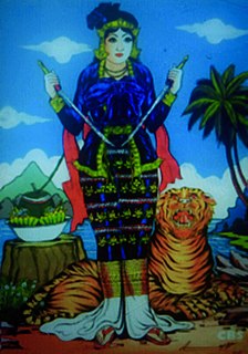
Amay Yay Yin is a prominent Burmese nat. She is also known to be one of the five mother nats as Anauk Medaw.
Dhammadara Ashin Vayamananda is a Burmese Theravada Buddhist monk.