
Magway Region is an administrative division in central Myanmar. It is the second largest of Myanmar's seven divisions, with an area of 44,820 km2. Pa Del Dam (ပဒဲဆည်) is one of the dams in Aunglan Township, Magway Division. The capital and second largest city of the Magway Division is Magway. The largest city is Pakokku. The major cities of Magway Division are Magway, Pakokku, Aunglan, Yenangyaung, Taungdwingyi, Chauk, Minbu, Thayet and Gangaw.

Sagaing Region is an administrative region of Myanmar, located in the north-western part of the country between latitude 21° 30' north and longitude 94° 97' east. It is bordered by India’s Nagaland, Manipur, and Arunachal Pradesh States to the north, Kachin State, Shan State, and Mandalay Region to the east, Mandalay Region and Magway Region to the south, with the Ayeyarwady River forming a greater part of its eastern and also southern boundary, and Chin State and India to the west. The region has an area of 93,527 km2. In 1996, it had a population of over 5,300,000 while its population in 2012 was 6,600,000. The urban population in 2012 was 1,230,000 and the rural population was 5,360,000. The capital city of Sagaing Region is Monywa.
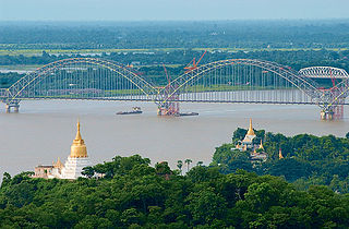
Sagaing is the former capital of the Sagaing Region of Myanmar. It is located in the Irrawaddy River, 20 km (12 mi) to the south-west of Mandalay on the opposite bank of the river. Sagaing with numerous Buddhist monasteries is an important religious and monastic centre. The pagodas and monasteries crowd the numerous hills along the ridge running parallel to the river. The central pagoda, Soon U Ponya Shin Pagoda, is connected by a set of covered staircases that run up the 240 m (790 ft) hill.

Kyunhla is a town in Kanbalu District, Sagaing Division in north-western Burma (Myanmar) about 70 kilometres east of Mawlaik. It is the administrative center of Kyunhla Township.
Thabeikkyin Township is a township of Pyin Oo Lwin District in the Mandalay Region of Burma. It is the northernmost township in Pyin Oo Lwin District and, although it primarily lies on the east bank of the Irrawaddy, it has a small enclave on the western bank extending as far as the village of Gagalaw, near the town of Baw in Katha District, Sagaing Region. On the south it borders Singu Township, on the east, Mogote Township and further north Shan State, while it abuts Tigyaing Township of Sagaing Region to the north.

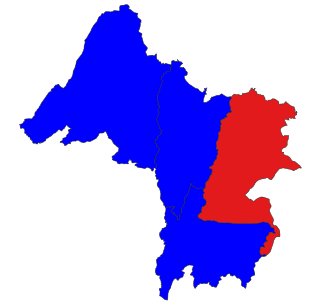
Bhamo District is a district of the Kachin State in northern Burma (Myanmar). The capital is the city of Bhamo. The district covers an area of 10,742.9 km2. In 2002, the population of the Bhamo District was an estimated 363,300. The district consists of four townships:

Danai is a town in Kachin State, in the northernmost part of Myanmar.
Salingyi is a town in Salingyi Township, Monywa District, Sagaing Region in Myanmar. It is the administrative seat for Salingyi Township, and is at a tri-crossroads with roads heading north-west to Yinmabin, north to Monywa, and south-west to Kyadet. On the east of town, there is a large textile mill which was completed in 2005.
Kanbalu is a town in Shwebo District, Sagaing Division, in Myanmar. It is the administrative seat for Kanbalu Township. Kanbalu is on the main Burmese north-south railroad between Sagaing and Myitkyina. As of 2014, it had a population of 25,022
Khamti, Hkamti, Singkawng, Kanti or Kantee is a town in Hkamti District, Sagaing Division, in north-western Myanmar. It is the administrative center for both the district and Hkamti Township.

Wetlet Township is a township of Shwebo District in the Sagaing Division of Burma (Myanmar). It is located on the plains between the Mu River and the Irrawaddy. Its administrative seat is the town of Wetlet.
Kale District is the westernmost district in Sagaing Division of Myanmar (Burma).

Kalewa Township is a township of Kale District in Sagaing Division of Burma (Myanmar). The principal town and administrative seat is Kalewa. The Paluzawa coal mines are located in Kalewa township.
Pauk Township is a township of Pakokku District in Magway Division of Burma (Myanmar). The principal town and administrative seat is Pauk.

Hkamti Township or Khamti Township is a township in Hkamti District in the Sagaing Region of Burma (Myanmar). The principal town is Hkamti. As of 2014 the township had a population of 47,658 people and covered an area of 8,174 square kilometres (3,156 sq mi). The township is dominated by the Chindwin River and its tributaries and thickly forested areas. Nearly half the active working population are employed in agriculture, forestry or fishing. The township is a producer of rice, and has reserves of gold and jade being mined.
Kale Township is a township in Kale District in the Sagaing Division of Burma (Myanmar). The principal town is Kalay.
Katha Township is a township in Katha District in the Sagaing Region of Burma. The principal town is Katha. The township is served by a branch (east-west) railway line that leaves the main line just north of Indaw.

Salingyi Township is a township in Yinmabin District in the Sagaing Division of Myanmar. The principal town is Salingyi.

Pale is a town in Pale Township, Yinmabin District, in southern Sagaing Region, Myanmar. It is the administrative seat of Pale Township. Pale is at a crossroads with one route going north to Yinmabin, one running west to Mindaingbin, and a third running south-east to Kyadet.
Yinmabin District is a newly created district in southern Sagaing Division, Burma (Myanmar); which was formerly part of Monywa District. Its administrative center is the city of Yinmabin.


