List of airports in Cambodia

Last updated

Map of Cambodia Cb-map.png
Map of Cambodia

This is a list of airports in Cambodia , sorted by location. Cambodia has only 3 major operating airports with commercial flights. The State Secretariat of Civil Aviation oversees the operations of all airports in Cambodia.

Contents

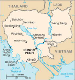
Cambodia, officially the Kingdom of Cambodia, is a country in Southeast Asia that borders Thailand to the west and northwest, Laos to the north and Vietnam to the east and southeast. In the south it faces the Gulf of Thailand. Phnom Penh is the capital and largest city. Siem Reap, a city located near the famed ruins of Angkor Wat is the gateway to the Angkor region, and is Cambodia's main destination for tourism. Battambang, the largest city in western Cambodia, is known for its rice production and Sihanoukville, a coastal city, is the primary sea port.

A fourth international airport in Koh Kong Province was announced in September 2016. [1]

Airports

Fully Operational Airports

City served Province ICAO IATA Airport name Coordinates
Phnom Penh Phnom Penh VDPPPNH Phnom Penh International Airport 11°32′47″N104°50′38″E / 11.54639°N 104.84389°E / 11.54639; 104.84389 (Phnom Penh International Airport)
Siem Reap Siem Reap VDSASAI Siem Reap–Angkor International Airport 13°22′31″N104°13′15″E / 13.37528°N 104.22083°E / 13.37528; 104.22083 (Siem Reap–Angkor International Airport)
Sihanoukville Sihanoukville VDSVKOS Sihanouk International Airport 10°34′46″N103°38′12″E / 10.57944°N 103.63667°E / 10.57944; 103.63667 (Sihanoukville International Airport)

Abandoned Airports

City served Province ICAO IATA Airport name Coordinates
Ban Lung Ratanakiri VDRKRBE Ratanakiri Airport 13°43′55″N106°59′01″E / 13.73194°N 106.98361°E / 13.73194; 106.98361 (Ratanakiri Airport (Ban Lung))
Battambang Battambang VDBGBBM Battambang Airport 13°05′44″N103°13′28″E / 13.09556°N 103.22444°E / 13.09556; 103.22444 (Battambang Airport)
Kampong Cham Kampong Cham VDKCKCA Kampong Cham Airport 12°01′44″N105°26′28″E / 12.02889°N 105.44111°E / 12.02889; 105.44111 (Kampong Cham Airport)
Kampong Chhnang Kampong Chhnang VDKHKZC Kampong Chhnang Airport 12°15′12″N104°34′03″E / 12.25333°N 104.56750°E / 12.25333; 104.56750 (Kampong Chhnang Airport)
Kampong Thom Kampong Thom KZK Kampong Thom Airport 12°47′02″N104°55′51″E / 12.78389°N 104.93083°E / 12.78389; 104.93083 (Kampong Thom Airport)
Kampot Kampot KMT Kampot Airport 10°37′59″N104°09′44″E / 10.63306°N 104.16222°E / 10.63306; 104.16222 (Kampot Airport)
Koh Kong Koh Kong VDKKKKZ Koh Kong Airport 11°36′47″N102°59′51″E / 11.61306°N 102.99750°E / 11.61306; 102.99750 (Koh Kong Airport)
Krakor Pursat VDSYKZD Krakor Airport 12°32′14″N104°08′54″E / 12.53722°N 104.14833°E / 12.53722; 104.14833 (Krakor Airport)
Kratié Kratié VDKTKTI Kratié Airport 12°29′22″N106°03′18″E / 12.48944°N 106.05500°E / 12.48944; 106.05500 (Kratié Airport)
Pailin Pailin PAI Pailin Airport
Senmonorom Mondulkiri VDMKMWV Mondulkiri Airport 12°27′45″N107°11′13″E / 12.46250°N 107.18694°E / 12.46250; 107.18694 (Mondulkiri Airport)
Stung Treng Stung Treng VDSTTNX Stung Treng Airport 13°31′54″N106°00′52″E / 13.53167°N 106.01444°E / 13.53167; 106.01444 (Stung Treng Airport)
Svay Rieng Svay Rieng SVR Svay Rieng Airport
Thbeng Meanchey Preah Vihear OMY Thbeng Meanchey Airport 13°45′37″N104°58′18″E / 13.76028°N 104.97167°E / 13.76028; 104.97167 (Thbeng Meanchey Airport)

Closed Airports

City served Province ICAO IATA Airport name Coordinates
Siem Reap Siem Reap VDSRREP Siem Reap International Airport 13°24′38″N103°48′46″E / 13.41056°N 103.81278°E / 13.41056; 103.81278 (Siem Reap International Airport)

Future Airports

City to be served Province ICAO IATA Airport name Coordinates
Botum Sakor, Khemarak Phoumin Koh Kong N/ADSY Dara Sakor International Airport 10°54′54″N103°13′26″E / 10.915°N 103.224°E / 10.915; 103.224 (Dara Sakor International Airport)
Phnom Penh Kandal N/AN/A Techo Takhmao International Airport 11°21′46.5″N104°54′59.8″E / 11.362917°N 104.916611°E / 11.362917; 104.916611 (Techo Takhmao International Airport)

See also

Map all coordinates using: OpenStreetMap

Related Research Articles

<span class="mw-page-title-main">Transport in Cambodia</span>

The system of transport in Cambodia, rudimentary at the best of times, was severely damaged in the chaos that engulfed the nation in the latter half of the 20th century. The country's weak transport infrastructure hindered emergency relief efforts, exacerbating the logistical issues of procurement of supplies in general and their distribution. Cambodia received Soviet technical assistance and equipment to support the maintenance of the transportation network.

<span class="mw-page-title-main">Phnom Penh</span> Capital and largest city of Cambodia

Phnom Penh is the capital and most populous city of Cambodia. It has been the national capital since the French protectorate of Cambodia and has grown to become the nation's primate city and its economic, industrial, and cultural centre. Before Phnom Penh became capital city, Oudong was the capital of the country.

Articles related to Cambodia and Cambodian culture include:

<span class="mw-page-title-main">Phnom Penh International Airport</span> Primary airport serving Phnom Penh, Cambodia

Phnom Penh International Airport is the busiest airport in Cambodia and serves as the country's main international gateway. It is Cambodia's second largest airport by area after the new Siem Reap–Angkor International Airport. It is located in the Pou Senchey District, 10 kilometres (5.4 NM) west of Phnom Penh, the nation's capital.

<span class="mw-page-title-main">Angkor Airways</span> Former Cambodian airline

Angkor Airways Corporation is a defunct airline that was based in Phnom Penh, Cambodia. This carrier started service in 2004 and had been substantially invested by Taiwan's Far Eastern Air Transport (FAT) as its subsidiary to make use of the Angkor International Airport in Siem Reap as its hub and as a fast transit station between Taiwan and People's Republic of China, while meantime also operated some charter flights in the East Asia and Southeast Asia region. All its fleets were wet leased from the FAT.

<span class="mw-page-title-main">Siem Reap International Airport</span> Former airport that served Siem Reap, Cambodia (1932–2023)

Siem Reap International Airport was an international airport serving Siem Reap and Angkor. It opened in 1932 and closed in 2023 upon the opening of Siem Reap–Angkor International Airport. It was the second-busiest airport in Cambodia after Phnom Penh International Airport.

<span class="mw-page-title-main">Royal Khmer Airlines</span>

Royal Khmer Airlines was a small airline based in Phnom Penh, Cambodia. It operated scheduled passenger services out of Phnom Penh International Airport and Angkor International Airport.

PMTair was a Cambodian airline offering regularly scheduled domestic and international passenger and cargo services out of Phnom Penh International Airport.

<span class="mw-page-title-main">Sihanouk International Airport</span> Cambodias third international airport, located in Sihanoukville, Cambodia

Sihanouk International Airport, located 20 kilometres (12 mi) east of Sihanoukville City in Sihanoukville Province, is Cambodia's third largest international airport. It is named, like the province itself, after King Norodom Sihanouk. The airport is also known as Kang Keng Airport. The IATA code KOS is derived from Sihanoukville's alternative name "Kampong Som".

Cambodia Angkor Air is the national flag carrier airline of Cambodia, with its corporate headquarters and main hub in Phnom Penh. The company slogan is "Proudly Serve the Kingdom".

<span class="mw-page-title-main">Sky Angkor Airlines</span> Cambodian airline

Sky Angkor Airlines Inc., formerly known as Skywings Asia Airlines, is an airline based in Cambodia. Its main hub is at Siem Reap International Airport and its second hub is in Phnom Penh International Airport. Sky Angkor Airlines is the first Cambodian airline to operate Airbus A320neo.

References

  1. "Coastal project gets nod". The Phnom Penh Post . 23 September 2016. Retrieved 7 October 2016.