Hobucken, North Carolina | |
|---|---|
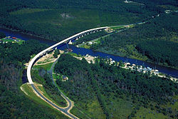 Aerial view of a stretch of the Intracoastal Waterway in Pamlico County, North Carolina, USA. The U.S. Army Corps of Engineers constructed the Hobucken Bridge over the waterway to replace an old swing-style drawbridge. The bridge carries NC state routes 33 and 304 over the waterway. | |
 Hobucken, North Carolina  Hobucken, North Carolina | |
| Coordinates: 35°15′16″N76°34′17″W / 35.25444°N 76.57139°W | |
| Country | United States |
| State | North Carolina |
| County | Pamlico |
| Area | |
• Total | 5.11 sq mi (13.24 km2) |
| • Land | 5.08 sq mi (13.16 km2) |
| • Water | 0.03 sq mi (0.08 km2) |
| Elevation | 0 ft (0 m) |
| Population (2020) | |
• Total | 99 |
| • Density | 19.49/sq mi (7.53/km2) |
| Time zone | UTC-5 (Eastern (EST)) |
| • Summer (DST) | UTC-4 (EDT) |
| ZIP code | 28537 |
| Area code | 252 |
| GNIS feature ID | 2628636 [2] |
Hobucken is an unincorporated community and census-designated place (CDP) in Pamlico County, North Carolina, United States. [2] Its population was 38 as of the 2020 census. Hobucken has a post office with ZIP code 28537. [3] [4] North Carolina Highway 33 and North Carolina Highway 304 pass through in the community.
