Holmes Township, Michigan

Last updated

Holmes Township, Michigan
Holmes Township, MI location2.png
Location within Menominee County and the state of Michigan
USA Michigan location map.svg
Red pog.svg
Holmes Township
Usa edcp location map.svg
Red pog.svg
Holmes Township
Coordinates: 45°30′53″N87°43′51″W / 45.51472°N 87.73083°W / 45.51472; -87.73083
Country United States
State Michigan
County Menominee
Area
[1]
  Total72.44 sq mi (187.6 km2)
  Land71.37 sq mi (184.8 km2)
  Water1.07 sq mi (2.8 km2)
Elevation
764 ft (233 m)
Population
 (2020) [2]
  Total341
  Density4.8/sq mi (1.9/km2)
Time zone UTC-6 (Central (CST))
  Summer (DST) UTC-5 (CDT)
ZIP Codes
49821 (Daggett)
49887 (Stepheson)
Area code 906
FIPS code 26-109-38760 [3]
GNIS feature ID1626481 [4]

Holmes Township is a civil township of Menominee County in the U.S. state of Michigan. The population was 341 at the 2020 census. [2]

Contents

Geography

The township is in western Menominee County and is bordered to the west, across the Menominee River, by Marinette County in Wisconsin. Menominee, the county seat, is 32 miles (51 km) to the south.

According to the United States Census Bureau, Holmes Township has a total area of 72.4 square miles (188 km2), of which 71.4 square miles (185 km2) are land and 1.1 square miles (2.8 km2), or 1.47%, are water. [1] The township is drained by the Menominee River, which flows south along the township's western boundary toward Lake Michigan.

Demographics

As of the census [3] of 2000, there were 296 people, 130 households, and 89 families residing in the township. In 2020, there were 341 people in the township. [2]

Related Research Articles

<span class="mw-page-title-main">Menominee County, Michigan</span> County in Michigan, United States

Menominee County is a county located in the Upper Peninsula in the U.S. state of Michigan. As of the 2020 census, the population was 23,502. The county seat is Menominee. The county's name comes from an American Indian word meaning "wild rice eater" used to describe a tribe. The county was created in 1861 from area partitioned out of Delta County, under the name of Bleeker. When county government was organized in 1863, the name was changed to Menominee.

<span class="mw-page-title-main">Breen Township, Michigan</span> Civil township in Michigan, United States

Breen Township is a civil township of Dickinson County in the U.S. state of Michigan. The population was 471 at the 2020 census.

<span class="mw-page-title-main">Michigamme, Michigan</span> Census-designated place & unincorporated community in Michigan, United States

Michigamme is an unincorporated community in Marquette County in the U.S. state of Michigan. It is located within Michigamme Township on the north shores of Lake Michigamme. For statistical purposes, the United States Census Bureau has defined Michigamme as a census-designated place (CDP). The CDP had a population of 255 at the 2020 census.

<span class="mw-page-title-main">Carney, Michigan</span> Village in Michigan, United States

Carney is a village in Menominee County of the U.S. state of Michigan. The population was 179 as of the 2020 census. The village is within Nadeau Township.

<span class="mw-page-title-main">Cedarville Township, Michigan</span> Civil township in Michigan, United States

Cedarville Township is a civil township of Menominee County in the U.S. state of Michigan. The population was 242 as of the 2020 census. The township was established in 1863.

<span class="mw-page-title-main">Daggett, Michigan</span> Village in Michigan, United States

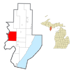
Daggett is a village in Menominee County of the U.S. state of Michigan. The population was 201 at the 2020 census, down from 258 in 2010. The village is located within Daggett Township and is part of the Marinette, WI–MI Micropolitan Statistical Area.

<span class="mw-page-title-main">Daggett Township, Michigan</span> Civil township in Michigan, United States

Daggett Township is a civil township of Menominee County in the U.S. state of Michigan. The population was 614 at the 2020 census, down from 714 in 2010. The village of Daggett is located within the township.

<span class="mw-page-title-main">Faithorn Township, Michigan</span> Civil township in Michigan, United States

Faithorn Township is a civil township of Menominee County in the U.S. state of Michigan. The population was 239 at the 2020 census.

<span class="mw-page-title-main">Gourley Township, Michigan</span> Civil township in Michigan, United States

Gourley Township is a civil township of Menominee County in the U.S. state of Michigan. The population was 451 at the 2020 census.

<span class="mw-page-title-main">Harris Township, Michigan</span> Civil township in Michigan, United States

Harris Township is a civil township of Menominee County in the U.S. state of Michigan. The population was 2,113 at the 2020 census.

<span class="mw-page-title-main">Ingallston Township, Michigan</span> Civil township in Michigan, United States

Ingallston Township is a civil township of Menominee County in the U.S. state of Michigan. The population was 924 at the 2020 census.

<span class="mw-page-title-main">Lake Township, Menominee County, Michigan</span> Civil township in Michigan, United States

Lake Township is a civil township of Menominee County in the U.S. state of Michigan. The population was 501 at the 2020 census, down from 556 in 2010.

<span class="mw-page-title-main">Mellen Township, Michigan</span> Civil township in Michigan, United States

Mellen Township is a civil township of Menominee County in the U.S. state of Michigan. The population was 1,109 at the 2020 census. It is named after pioneer settler Mellen Smith (1829–1905), who served as the first postmaster at Wallace.

<span class="mw-page-title-main">Menominee Township, Michigan</span> Civil township in Michigan, United States

Menominee Township is a civil township of Menominee County in the U.S. state of Michigan. The population was 3,364 at the 2020 census, down from a peak of 4,026 in 1980. The city of Menominee borders the southern end of the township but is administratively autonomous.

<span class="mw-page-title-main">Meyer Township, Michigan</span> Civil township in Michigan, United States

Meyer Township is a civil township of Menominee County in the U.S. state of Michigan. The population was 992 at the 2020 census. Most of the population is concentrated in Hermansville, an unincorporated village within the township.

<span class="mw-page-title-main">Nadeau Township, Michigan</span> Civil township in Michigan, United States

Nadeau Township is a civil township of Menominee County in the U.S. state of Michigan. The population was 1,090 at the 2020 census.

<span class="mw-page-title-main">Powers, Michigan</span> Village in Michigan, United States

Powers is a village in Menominee County in the U.S. state of Michigan. The population was 381 at the 2020 census, down from 422 in 2010. Located within Spalding Township, it is part of the Marinette micropolitan area.

<span class="mw-page-title-main">Spalding Township, Michigan</span> Civil township in Michigan, United States

Spalding Township is a civil township of Menominee County in the U.S. state of Michigan. The population was 1,599 at the 2020 census. It is named after Jesse Spalding (1833–1904), who operated a steam sawmill at the village in the township that now bears his name.

<span class="mw-page-title-main">Stephenson, Michigan</span> City in Michigan, United States

Stephenson is a city in Menominee County in the U.S. state of Michigan. The population was 816 at the 2020 census. The city is surrounded by Stephenson Township but is administered autonomously. It is part of the Marinette, WI–MI micropolitan statistical area.

<span class="mw-page-title-main">Stephenson Township, Michigan</span> Civil township in Michigan, United States

Stephenson Township is a civil township of Menominee County in the U.S. state of Michigan. The population was 616 at the 2020 census. The city of Stephenson is surrounded by the township but is administered autonomously.

References

  1. 1 2 "2022 U.S. Gazetteer Files: Michigan". United States Census Bureau. Retrieved October 10, 2023.
  2. 1 2 3 "P1. Race – Holmes township, Michigan: 2020 DEC Redistricting Data (PL 94-171)". U.S. Census Bureau. Retrieved October 10, 2023.
  3. 1 2 "U.S. Census website". United States Census Bureau . Retrieved January 31, 2008.
  4. U.S. Geological Survey Geographic Names Information System: Holmes Township, Michigan