Hermansville, Michigan

Last updated

Hermansville, Michigan
HermansvilleMichiganDowntown.jpg
Looking east at downtown Hermansville
USA Michigan location map.svg
Red pog.svg
Hermansville
Usa edcp location map.svg
Red pog.svg
Hermansville
Coordinates: 45°42′39″N87°36′05″W / 45.71083°N 87.60139°W / 45.71083; -87.60139
Country United States
State Michigan
County Menominee
Township Meyer
Area
[1]
  Total1.41 sq mi (3.7 km2)
  Land1.27 sq mi (3.3 km2)
  Water0.14 sq mi (0.4 km2)
Population
 (2020) [2]
  Total509
  Density399.8/sq mi (154.4/km2)
Time zone UTC-6 (Central (CST))
  Summer (DST) UTC-5 (CDT)
ZIP Code
49847
Area code 906
FIPS code 26-37760
DesignatedSeptember 17, 1974

Hermansville is an unincorporated community and census-designated place (CDP) in Meyer Township of Menominee County in the U.S. state of Michigan. [3] As of the 2020 census, it had a population of 509. [2] The community formed around the defunct Wisconsin Land & Lumber Company as a company town. The company's former headquarters is open as the IXL Historical Museum. US Highway 2 (US 2) passes through the north edge of the community.

Contents

History

The village of Hermansville was founded in 1878 by C.J.L. Meyer of Fond du Lac, Wisconsin, who built and operated a saw and shingle mill utilizing the abundant native cedar and pine growing in the area. The community was named for the son of the original owner of the town site. [4] In 1883 Meyer organized the Wisconsin Land & Lumber Company, which acquired the mill and landholdings, and began working on methods of utilizing the abundant hardwood timber on the surrounding lands held by the company. The company eventually developed innovative new methods and machinery for manufacturing pre-cut maple wood flooring; previous techniques for cutting and shaping maple in the United States were laborious and inefficient because of the hard, brittle nature of maple wood. The IXL brand became a popular choice for flooring, due to its virtually indestructible nature and its rich color and grain. The company also utilized other varieties of wood growing in the area for various products. [5]

A thriving company town grew quickly as the mill prospered, with over 200 company-owned dwellings built for employees and their families. A passenger rail depot, general stores, taverns, a bank, library and post office were established, as was a multi-grade public school. Other industry developed in the area as well, aided by the town's proximity to abundant rail freight service and local natural resources.

The town's growth slowed and eventually declined, due to the rapid deforestation and subsequent scarcity of the timber that drove Hermansville's economy. Starting in the 1920s the IXL Company began selling off the individual dwellings and parcels of land on the village property - mostly to the employees who inhabited them. The village population dropped significantly, and most of the small businesses which catered to local people were eventually closed. By the end of World War II the village's homes were all privately owned, and the IXL Company ceased all operations in Meyer Township by the end of the 1960s. The village of Hermansville now serves as the township seat. [5]

Geography

The community is in northwestern Menominee County. U.S. Route 2 leads west 16 miles (26 km) to Norway and east 27 miles (43 km) to Escanaba. Menominee, the county seat, is 46 miles (74 km) to the south via US 2 and US 41.

According to the U.S. Census Bureau, the Hermansville CDP has a total area of 1.41 square miles (3.7 km2), of which 1.27 square miles (3.3 km2) are land and 0.14 square miles (0.36 km2), or 9.72%, are water. [1]

Recreation and places of interest

As an aid to transport of lumber and for recreational and domestic purposes, the Little Cedar River, a small waterway that passes west of the village, was dammed in the early 20th century, creating a reservoir named Hermansville Lake. The lake is divided into two parts by a raised rail line, and is visually distinctive, as hundreds of tree stumps from trees cut down long ago jut up from the lake bottom. A public sand beach with restrooms is located at the west end of First Street, with public restrooms and a pavilion. The reservoir is currently being improved and, after being diverted and drained in 2006 for stump removal and railroad improvement issues, was dammed and refilled in the spring of 2008. [6]

The IXL Historic Museum, dedicated to the area's early history as a company town, is located in the heart of Hermansville. The main exhibits of the museum are housed in the well-preserved office building of the Wisconsin Land & Lumber Company, a fine example of Queen Anne architecture completed in 1883. One of the most popular stops on the museum tour is at the perfectly preserved main office, which has changed little over the past 100 years. Other buildings on the museum grounds, most relocated from other locations and restored, are also part of the tour – including an early company (worker) house, a railroad depot, and a vast collection of antique turn-of-the-century machinery. The museum and its gift shop are open daily during the summer, and is available for tours at other times of the year by appointment. [7]

The Thomas St. Onge Vietnam Veterans Museum is located in the center of Hermansville, and features exhibits pertaining to the Vietnam War. A decommissioned UH-1 "Huey" helicopter is on permanent display at the site, as well as a full Battle Tank which served in the war. The museum is sponsored by Vietnam Veterans of America, Thomas St. Onge Chapter 571, and is open afternoons daily during the summer. [8]

The village in its entirety is notable for its unique history as a company town, and although the population declined significantly throughout the 20th century and most of the central businesses are closed, many of the original structures and homes remain, and the village looks much as it did in the early 20th century. According to author and historian Kathryn Eckert, Hermansville is "one of the state's best examples of a wood products company town." [9]

Images

Related Research Articles

<span class="mw-page-title-main">Menominee County, Michigan</span> County in Michigan, United States

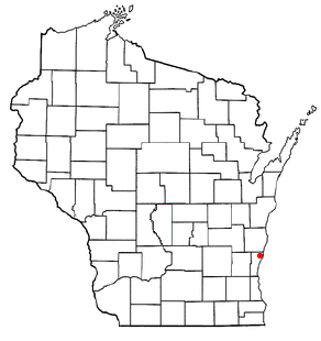
Menominee County is a county located in the Upper Peninsula in the U.S. state of Michigan. As of the 2020 Census, the population was 23,502. The county seat is Menominee. The county's name comes from an American Indian word meaning "wild rice eater" used to describe a tribe. The county was created in 1861 from area partitioned out of Delta County, under the name of Bleeker. When county government was organized in 1863, the name was changed to Menominee.

<span class="mw-page-title-main">Alcona Township, Michigan</span> Civil township in Michigan, United States

Alcona Township is a civil township of Alcona County in the U.S. state of Michigan. The population was 966 at the 2020 census.

<span class="mw-page-title-main">Lake Township, Menominee County, Michigan</span> Civil township in Michigan, United States

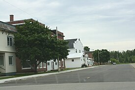
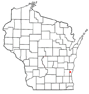
Lake Township is a civil township of Menominee County in the U.S. state of Michigan. The population was 501 at the 2020 census, down from 556 in 2010.

<span class="mw-page-title-main">Menominee, Michigan</span> City in Michigan, United States

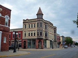
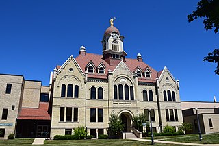
Menominee is a city in the Upper Peninsula of the U.S. state of Michigan. The population was 8,488 at the 2020 census. It is the county seat of Menominee County. Menominee is the fourth-largest city in the Upper Peninsula, behind Marquette, Sault Ste. Marie, and Escanaba. Menominee Township is located to the north of the city, but is politically autonomous.

<span class="mw-page-title-main">Meyer Township, Michigan</span> Civil township in Michigan, United States

Meyer Township is a civil township of Menominee County in the U.S. state of Michigan. The population was 992 at the 2020 census. Most of the population is concentrated in Hermansville, an unincorporated village within the township.

<span class="mw-page-title-main">Houghton Lake, Michigan</span> Census-designated place & unincorporated community in Michigan, United States

Houghton Lake is an unincorporated community and census-designated place (CDP) in Roscommon County in the U.S. state of Michigan. The population was 5,294 at the time of the 2020 census, making it the largest unincorporated community in Northern Michigan. The CDP is located within Denton, Lake, and Roscommon townships.

<span class="mw-page-title-main">Marinette, Wisconsin</span> City in Wisconsin, United States

Marinette is a city in and the county seat of Marinette County, Wisconsin, United States. It is located on the south bank of the Menominee River, at its mouth at Green Bay, part of Lake Michigan; to the north is Stephenson Island, part of the city preserved as park. During the lumbering boom of the late 19th century, Marinette became the tenth-largest city in Wisconsin in 1900, reaching a peak population of 16,195.

<span class="mw-page-title-main">Middle Village, Wisconsin</span> CDP in Wisconsin, United States

Middle Village is a census-designated place (CDP), in the towns of Menominee and Red Springs, in Menominee and Shawano counties in the U.S. state of Wisconsin. It does not have any legal status as an incorporated municipality. The population was 290 at the 2020 census.

<span class="mw-page-title-main">Oconto, Wisconsin</span> City in Wisconsin, United States

Oconto is a city in Oconto County, Wisconsin, United States. The population was 4,609 at the 2020 census. It is part of the Green Bay Metropolitan Statistical Area. The city is located partially within the town of Oconto.

<span class="mw-page-title-main">Belgium (town), Wisconsin</span> Town in Ozaukee County, Wisconsin

Belgium is a town in Ozaukee County, Wisconsin, United States. The population was 1,513 at the 2000 census. The Village of Belgium is surrounded on all sides by the town, and the unincorporated communities of Decker, Holy Cross, Lake Church, and Sauk Trail Beach are located in the town, as is the ghost town of Stonehaven. The unincorporated community of Dacada is also partially located in the town.

<span class="mw-page-title-main">Saukville (town), Wisconsin</span> Town in Ozaukee County, Wisconsin

Saukville is a town in Ozaukee County, Wisconsin, United States. The Village of Saukville is located in the town's southeast quadrant. The population was 1,755 at the 2000 census.

<span class="mw-page-title-main">Leland, Michigan</span> Census-designated place & unincorporated community in Michigan, United States

Leland is an unincorporated community and census-designated place (CDP) in the U.S. state of Michigan. It is located in Leelanau County, part of the northwestern Lower Peninsula of the state. As of the 2020 census it had a population of 410. From 1883 to 2004, Leland was the county seat of Leelanau County, which has since moved to Suttons Bay Township.

<span class="mw-page-title-main">Menominee</span> Federally-recognized indigenous people of the United States

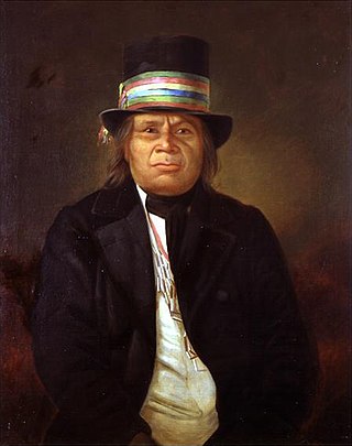
The Menominee are a federally recognized tribe of Native Americans officially known as the Menominee Indian Tribe of Wisconsin. Their land base is the Menominee Indian Reservation in Wisconsin. Their historic territory originally included an estimated 10 million acres (40,000 km2) in present-day Wisconsin and the Upper Peninsula of Michigan. The tribe currently has about 8,700 members.

Onalaska is an unincorporated community and census-designated place (CDP) in Lewis County, Washington, United States. As of the 2020 census it had a population of 657. Onalaska is located along Washington State Route 508.

<span class="mw-page-title-main">National Register of Historic Places listings in Menominee County, Michigan</span>

This is a list of the National Register of Historic Places listings in Menominee County, Michigan.

<span class="mw-page-title-main">Menominee Indian Reservation</span> Indian reservation in United States, Menominee Indian Tribe of Wisconsin

The Menominee Indian Reservation is an Indian reservation located in northeastern Wisconsin held in trust by the United States for the Menominee Tribe of Wisconsin. It is the largest Indian reservation east of the Mississippi River. In the Menominee language, it is called Omāēqnomenēw-Otāēskonenan, "Menominee Thing Set Apart", or alternatively omǣqnomenēw-ahkīheh, "in the Menominee Country".

<span class="mw-page-title-main">Laona (CDP), Wisconsin</span> Census-designated place in Wisconsin, United States

Laona is an unincorporated census-designated place in the town of Laona in Forest County, Wisconsin, United States. U.S. Route 8 travels east–west through the community and Wisconsin Highway 32 travels south and west of the community. The community park has a sign stating that the community donated the 1979 Christmas tree at the nation's capitol. As of the 2010 census, its population is 583.

<span class="mw-page-title-main">IXL Historical Museum</span> United States historic place

The IXL Historical Museum is a historic office building, residence, and museum complex in Hermansville, Michigan, United States. The main building was constructed as the headquarters for the Wisconsin Land & Lumber Company before it became a museum. The museum was organized in 1982, and the main building, also known as the Wisconsin Land and Lumber Company Office, was designated a Michigan State Historic Site in 1973 and listed on the National Register of Historic Places in 1991.

<span class="mw-page-title-main">Florence (CDP), Wisconsin</span> Census-designated place in Wisconsin, United States

Florence is a census-designated place in and the county seat of Florence County, Wisconsin, United States. Florence is located in northern Florence County, in the town of Florence. Florence has a post office with ZIP code 54121. The community was named a census-designated place in 2010. As of the 2010 census, its population was 592.

Koss is an unincorporated community in Menominee County, Michigan, United States. Koss is located in Lake Township, 4.9 miles (7.9 km) west-southwest of Stephenson.

References

  1. 1 2 "2022 U.S. Gazetteer Files: Michigan". United States Census Bureau. Retrieved September 28, 2023.
  2. 1 2 "P1. Race – Hermansville CDP, Michigan: 2020 DEC Redistricting Data (PL 94-171)". U.S. Census Bureau. Retrieved September 28, 2023.
  3. "Hermansville, Michigan". Geographic Names Information System . United States Geological Survey, United States Department of the Interior.
  4. Chicago and North Western Railway Company (1908). A History of the Origin of the Place Names Connected with the Chicago & North Western and Chicago, St. Paul, Minneapolis & Omaha Railways. p. 83.
  5. 1 2 IXL Museum Archived 2008-07-24 at the Wayback Machine
  6. Hermansville Lake Fishing in Menominee County, Michigan | Fishing Works
  7. "IXL Museum". Archived from the original on March 4, 2008. Retrieved June 22, 2008.
  8. Vietnam Veterans Museum Hermansville Michigan Archived 2008-05-09 at the Wayback Machine
  9. Hermansville – Michigan's Upper Peninsula