
Menominee is a village in Jo Daviess County, Illinois, United States. The population was 248 at the 2010 census, up from 237 in 2000. The village is located on the Little Menominee River near East Dubuque and Galena.

Athens is a village in Calhoun County in the U.S. state of Michigan. The population was 936 at the 2020 census. The village is located in southern Athens Township, and is part of the Battle Creek, Michigan Metropolitan Statistical Area. It was settled in 1831.

Burlington is a village in Calhoun County in the U.S. state of Michigan. The population was 281 at the 2020 census. It is part of the Battle Creek, Michigan Metropolitan Statistical Area. The village is located within Burlington Township on M-60.
Bay de Noc Township is a civil township of Delta County in the U.S. state of Michigan. As of the 2020 census, the township population was 300, slightly down from 305 at the 2010 census. The township covers the southern portion of the Stonington Peninsula separating Little Bay de Noc and Big Bay de Noc on Lake Michigan.

Norway is a city in Dickinson County in the U.S. state of Michigan. The population was 2,840 at the 2020 census. It is part of the Iron Mountain, MI–WI micropolitan statistical area.

Copper City is a village in Houghton County of the U.S. state of Michigan. The population was 187 at the 2020 census. The village is within Calumet Township. With an area of 0.08 square miles (0.21 km2), it is the second-smallest incorporated municipality by area in the state of Michigan after the nearby village of Ahmeek.
Elkton is a village in Huron County in the U.S. state of Michigan. The population was 796 at the 2020 census. The village is within Oliver Township, along the Pinnebog River. It was incorporated in 1897.

Carney is a village in Menominee County of the U.S. state of Michigan. The population was 179 as of the 2020 census. The village is within Nadeau Township.

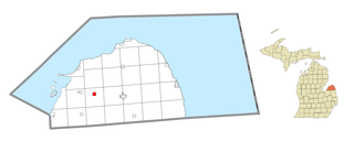
Daggett is a village in Menominee County of the U.S. state of Michigan. The population was 201 at the 2020 census, down from 258 in 2010. The village is located within Daggett Township and is part of the Marinette, WI–MI Micropolitan Statistical Area.

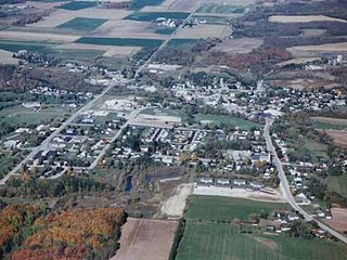
Stephenson is a city in Menominee County in the U.S. state of Michigan. The population was 816 at the 2020 census. The city is surrounded by Stephenson Township but is administered autonomously. It is part of the Marinette, WI–MI micropolitan statistical area.

Spring Lake is a village in Ottawa County in the U.S. state of Michigan. The population was 2,497 at the 2020 census. The village is located within Spring Lake Township; the two share a ZIP code.

Centreville is a village in the U.S. state of Michigan and the county seat of St. Joseph County. The population was 1,425 at the 2010 census.

Spalding is a village in Greeley County, Nebraska, United States. The population was 408 at the 2020 census.
Aurora is a town in Florence County, Wisconsin, United States. The population was 1,186 at the 2000 census. Aurora lies on the Michigan-Wisconsin border, across the Menominee River from Kingsford, Michigan.

Suring is a village in Oconto County, Wisconsin, United States, along the 45th parallel. The population was 544 at the 2010 census. It is part of the Green Bay Metropolitan Statistical Area.

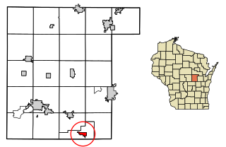
Waukechon is a town in Shawano County, Wisconsin, United States. The population was 928 at the 2000 census. The unincorporated community of Lunds is located in the town. Its Menominee name is Wākecānāpāēw, meaning "crooked beak man", a reference to the Thunderbird Clan of the Ho-Chunk.

Middle Village is a census-designated place (CDP), in the towns of Menominee and Red Springs, in Menominee and Shawano counties in the U.S. state of Wisconsin. It does not have any legal status as an incorporated municipality. The population was 290 at the 2020 census.
Mishicot is a village in Manitowoc County, Wisconsin, United States. The population was 1,442 at the 2010 census. The village is adjacent to the Town of Mishicot.
Fremont is a village in Waupaca County, Wisconsin, United States. It is surrounded by Town of Fremont. The population was 679 at the 2010 census. Fremont has been referred to as the "White Bass Capital of the World."
Waupaca is a city in and the county seat of Waupaca County in the U.S. state of Wisconsin. The population was 6,282 at the 2020 census.


