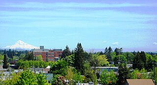
Hillsboro is a city in the U.S. state of Oregon and is the county seat of Washington County. Situated in the Tualatin Valley on the west side of the Portland metropolitan area, the city hosts many high-technology companies, such as Intel, locally known as the Silicon Forest. The population was 106,447 at the 2020 census, making Hillsboro the 5th most populous city in Oregon.

Willow Creek/Southwest 185th Avenue Transit Center is a multimodal transport hub in Hillsboro, Oregon, United States. Owned and operated by TriMet, it is served by bus and light rail. The transit center is the ninth station eastbound on the Blue Line and a hub for bus routes mostly serving Washington County in the Portland metropolitan area. It is located by the intersection of Southwest Baseline Road and 185th Avenue near the city's boundary with Beaverton.

Quatama, formerly Quatama/Northwest 205th Avenue, is a light rail station in Hillsboro, Oregon, United States, that is served by TriMet as part of the MAX Light Rail system. Situated between Orenco station and Willow Creek/Southwest 185th Avenue Transit Center, it is the seventh eastbound station on the Blue Line. The two-track, island platform station includes a park-and-ride lot. Quatama Station is named after the area which includes Quatama Road to the south of the station. Opened in 1998, the stop is near high-tech industries and the Amberglen business park, which includes Oregon Health & Science University's West Campus and the Oregon National Primate Research Center. With the renaming of Northwest 205th Avenue to Northeast John Olsen Avenue by the city of Hillsboro in 2017, TriMet changed the station's name from its original, longer name.

Point Isabel Regional Shoreline in Richmond, California, is operated by East Bay Regional Park District, and is a multi-use park for joggers, windsurfers, kayakers, photographers, picnickers, and people walking dogs. It has access for pedestrians and via public transit, private vehicles, and bikes. It also features a concession offering food for people and grooming for pets. A longtime community organization and nonprofit, Point Isabel Dog Owners and Friends (PIDO), is active in the maintenance and improvement of the park.

Tanasbourne, Oregon, is a neighborhood in Washington County, Oregon, where NW 185th Avenue and the Sunset Highway intersect. It is located within the greater Portland metropolitan area. The area includes portions of Beaverton and Hillsboro, and is generally considered to be south of U.S. 26, north of Walker Road, west of 158th, and east of Cornelius Pass Road. Adjacent to Aloha and part of the West Metro region, Tanasbourne has many shopping areas and is the former home of the defunct Tanasbourne Mall.
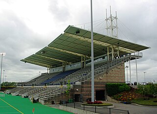
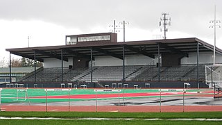
Hillsboro Stadium is a multi-sport stadium in the northwest United States, located in Hillsboro, Oregon, a suburb west of Portland. Opened 25 years ago in 1999 and owned by the city of Hillsboro, the award-winning stadium is part of the Gordon Faber Recreation Complex located in the northeast part of the city, adjacent to the Sunset Highway.
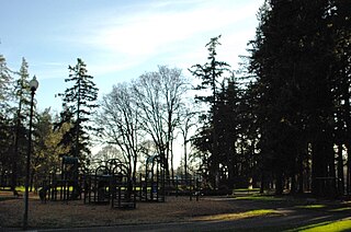
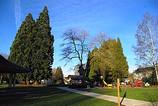
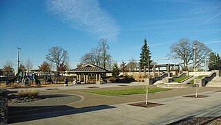
Shute Park is a municipal park in the city of Hillsboro, Oregon, United States. Acquired in 1906, the 13-acre (53,000 m2) park is the oldest park in the city. Located at southeast Tenth and Maple streets along Tualatin Valley Highway, Shute Park includes an aquatic center, a branch of the Hillsboro Public Library, and a community center. The park once had a pavilion that contained a roller skating rink, and was the center of civic activities before the opening of the Washington County Fairgrounds. Named for businessman John W. Shute, the park at one time included land on the east side of the highway that consisted mainly of a baseball field.

L. L. "Stub" Stewart Memorial State Park is a 1,654-acre (669 ha) Oregon state park in Washington County near the community of Buxton. When the park opened in 2007 it was the first new full-service state park in Oregon since 1972. The park includes hiking trails, mountain bike trails, horseback riding, RV and tent campsites, and cabins among other amenities. Located off Oregon Route 47 in the foothills of the Northern Oregon Coast Range, the park connects to the Banks–Vernonia State Trail.

The Hillsboro Police Department (HPD) is the municipal law enforcement agency of the city of Hillsboro, Oregon, United States. It is a regionally accredited agency with 127 sworn officers on the force. The chief is Jim Coleman in a city of over 90,000 residents west of Portland, Oregon, in Washington County. With 169 employees as of 2014, the department is the second largest police force in the county and seventh largest in Oregon.

Gabriel Park is a 90.65-acre (366,800 m2) public park in Portland, Oregon, United States. It features a baseball field, softball field, soccer field, basketball courts, tennis courts, skatepark, volleyball courts, disabled access play area, disabled access restrooms, dog off-leash area, paved and unpaved paths, reservable picnic sites, and WiFi. The park is located between the Maplewood, Multnomah, and Hillsdale neighborhoods of Southwest Portland at 45th Avenue and Vermont Street.
Hare Field is a multi-sport facility located in Hillsboro, Oregon, United States. The facility opened in 1965 and is owned by the Hillsboro School District. Hare Field includes a baseball stadium, a football stadium, practice fields, and track and field equipment. The venue hosts high school sports, open track meets, youth sports, and occasionally college sports. The football stadium seats over 5,000 fans, was the first high school field in Oregon with an all-weather field, and was named one of the best venues to watch high school football in the state.

The Pacific University Health Professions Campus is a satellite campus of Pacific University located in downtown Hillsboro, Oregon, United States. Opened in 2006, the campus contains the school's College of Health Professions with plans to move Pacific's College of Optometry and School of Professional Psychology in later phases. Housed in two brick buildings, the campus is located in the city's Health and Education District and adjacent to the Tuality Hospital/Southeast 8th Avenue light rail station. The campus of Tuality Community Hospital is across Baseline Street to the south.
Bagley Park is a two-acre municipal park in downtown Hillsboro, Oregon, United States. Opened in 1926, the park covers a half-block at northeast Second Avenue and Jackson Street north of the Washington County Courthouse. After a major renovation project ending in 2008, the park includes a picnic shelter, a playground, restrooms, and several sports facilities.

Magnolia Park is a municipal park in the Tanasbourne neighborhood of Hillsboro, Oregon. Opened in 2008, the 3.11 acres (12,600 m2) community park is off northwest 102nd avenue between Walker and Cornell roads near the Streets of Tanasbourne shopping center. The park includes a basketball court, children's play equipment, picnic shelter, tennis court, and water fountain designed for cooling among other amenities.
Reedville Creek Park is a municipal park in the Reedville neighborhood of Hillsboro, Oregon, United States. Opened in 2003, the 9.6-acre (39,000 m2) park is along Cornelius Pass Road at Francis Street in the southeast area of the city. The park includes basketball courts, children’s play equipment, a picnic shelter, tennis courts, and sports fields among other amenities. Reedville Creek was the first and is the only park in Hillsboro with a skatepark.

Hidden Creek Park East, formerly known as 53rd Avenue Community Park, is a municipal park in Hillsboro, Oregon, United States. Partially opened in 2008, the park covers 43.5 acres (17.6 ha) along northeast 53rd Avenue in the middle of the city. The park includes two multi-purpose sports fields covered with artificial turf along with basketball courts, tennis courts, and a water fountain. Its neighboring park, Hidden Creek Park West, contains an indoor recreation center which include exercise facilities and a gymnasium along with outdoor park items that include children's play equipment, a combined futsal/pickleball court, and walking trails. Plans call for a aquatics center to be built in the near future. Land for both parks were purchased from exercise equipment maker Soloflex beginning in 2001.

Turner Creek Park is a municipal park in Hillsboro in the U.S. state of Oregon. Opened about 1990, the 12.5-acre (51,000 m2) park is located in the middle of the city along Turner Creek near southwest 32nd Avenue between Tualatin Valley Highway and Main Street. The park includes a playground, restrooms, several sports facilities, and natural areas with trails.

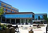
Kaiser Westside Medical Center is a hospital in the Tanasbourne neighborhood in Hillsboro in the U.S. state of Oregon. Opened in August 2013 with 126 hospital beds, the Kaiser Permanente facility is planned to later expand to 174 beds. It was designed by Ellerbe Becket Architects and Petersen Kolberg & Associates Architects/Planners. The $220 million hospital includes Kaiser's Sunset Medical Office that opened in 1987 on the west side of the Portland metropolitan area.

Virginia Garcia Memorial Health Center is a non-profit organization that provides primary health care in Washington and Yamhill counties in the U.S. state of Oregon. Established in 1975, Virginia Garcia operates five medical clinics, five dental clinics, one women's clinic as well as six school-based health centers, and is based in Cornelius, Oregon. The organization was founded to provide medical care to migrant and farm workers and those with barriers to care. It was named after the daughter of migrant workers who died after failing to receive medical treatment for an infected cut on her foot. In 2016, Virginia Garcia had revenues of $60 million and served 45,000 patients.

Cornell Creek Park is a city park in Hillsboro, Oregon, United States. Opened in 2016, it has the second dog park in the city after Hondo Dog Park. Located in the Orenco Station neighborhood along Cornell Road, it has just over four acres that is bisected by a small creek.