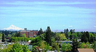
Hillsboro is a city in the U.S. state of Oregon and is the county seat of Washington County. Situated in the Tualatin Valley on the west side of the Portland metropolitan area, the city hosts many high-technology companies, such as Intel, locally known as the Silicon Forest. The population was 106,447 at the 2020 census, making Hillsboro the 5th most populous city in Oregon.
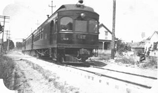
The Oregon Electric Railway (OE) was an interurban railroad line in the U.S. state of Oregon that linked Portland to Eugene.

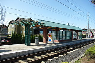
Hillsboro Central/Southeast 3rd Avenue Transit Center, also known as Hillsboro Transit Center, is a light rail station and transit center on the MAX Blue Line in Hillsboro, Oregon. Opened in 1998, the red-brick station is the 19th stop westbound on the Westside MAX, one stop from the western terminus of the line. Physically the largest station on the line, it is located at a former stop of the Oregon Electric Railway and includes artwork honoring the history of the community.

Elmonica/Southwest 170th Avenue is a light rail station on the MAX Blue Line in Beaverton, Oregon, United States. Named after a former station on the Oregon Electric Railway, it is the eleventh stop westbound on the Westside MAX. The side platform stop is located between Hillsboro to the west and Beaverton to the east.

Quatama, formerly Quatama/Northwest 205th Avenue, is a light rail station in Hillsboro, Oregon, United States, that is served by TriMet as part of the MAX Light Rail system. Situated between Orenco station and Willow Creek/Southwest 185th Avenue Transit Center, it is the seventh eastbound station on the Blue Line. The two-track, island platform station includes a park-and-ride lot. Quatama Station is named after the area which includes Quatama Road to the south of the station. Opened in 1998, the stop is near high-tech industries and the Amberglen business park, which includes Oregon Health & Science University's West Campus and the Oregon National Primate Research Center. With the renaming of Northwest 205th Avenue to Northeast John Olsen Avenue by the city of Hillsboro in 2017, TriMet changed the station's name from its original, longer name.
Orenco is a light rail station in Hillsboro, Oregon, United States, served by TriMet as part of the MAX Light Rail system. It is the seventh station eastbound on the Blue Line, situated between the Quatama and Hawthorn Farm stations. The two-track, island platform station serves the Orenco Station neighborhood, which is considered a model for smart growth and transit-oriented development. It features a 125-space park and ride, a bike and ride, and connections to TriMet bus route 47–Baseline/Evergreen and Ride Connection's North Hillsboro Link.

The Hillsboro School District 1J is a unified school district located in Hillsboro, Oregon, United States. The district operates 26 elementary schools, four middle schools, and four high schools. Founded in 1851, the school district covers Hillsboro, Scholls, Reedville, North Plains, West Union, and other area communities. Total enrollment as of the 2019–2020 school year is 20,269 students, the fourth largest in the state.

Orenco Station is a neighborhood of the city of Hillsboro, Oregon, United States. The planned urban town center was designed as a pedestrian-friendly, high-density community built in conjunction with TriMet’s Westside light rail. It was built on land formerly owned by the Oregon Nursery Company, land home around the turn of the 20th century to Orenco, a company town. During the Great Depression, the company went out of business, and much of the nursery land became vacant until re-development began in 1997. Orenco Station is near the intersection of NE Century Blvd. and Cornell Road, centered on the Orenco MAX Station.

Noble Woods Park is a wooded city park in Hillsboro, Oregon, United States. Located on approximately 40 acres (160,000 m2) along Rock Creek, the nature park with wetlands and forests is situated between West Baseline Road on the north and Southwest Borwick Road to the south near the Orenco neighborhood. The city acquired the land for the park in 1992 and opened the park in the eastern section of the city in 1998. Noble Woods has two entrances, a picnic area, and hiking trails.

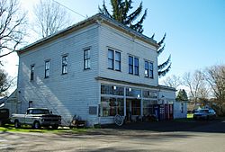
Laurel is an unincorporated community in Washington County, Oregon, United States. Settled in 1872, the community is located between Hillsboro and Newberg, in the southern portion of the Tualatin Valley in the foothills of the Chehalem Mountains. The community retains its agricultural heritage. Laurel is served by the Hillsboro School District and includes the century-old Laurel Valley Store building, which is in the process of being turned into a restaurant. As an unincorporated community, Laurel has no defined boundaries or population statistics of its own.

The Oregon Nursery Company was a nursery company founded and originally operated in Salem, Oregon, United States. The company later expanded to a site in Washington County, Oregon west of Portland. The entire operation was eventually moved to Washington County, where the company founded the town of Orenco. The company went bankrupt in 1927. Its legacy is the Orenco place name that is still widely used in the Hillsboro area.

The Southern Pacific Red Electric Lines, also known simply as the Red Electric, was a network of interurban passenger train services operated by the Southern Pacific Railroad in the Willamette Valley of the U.S. state of Oregon from 1914 to 1929. The service got its name from the bright red color of its cars. Despite its short history, among West Coast interurbans it was unique, and it was considered the finest such system in the Pacific Northwest. It was the only major electric interurban railroad converted from steam to electric passenger use. It was also one of few systems using all-steel equipment, and one of the largest 1500-volt systems in the country.
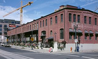
The North Bank Depot Buildings, in central Portland, Oregon, United States, are a pair of buildings formerly used as a freight warehouse and passenger terminal for the Spokane, Portland and Seattle Railway (SP&S). Formed in 1905, the SP&S was commonly known as the North Bank Road during the period in which these buildings were in use. The Portland buildings' passenger facilities were also used by the Oregon Electric Railway after that railway was acquired by the SP&S. Located in what is now known as the Pearl District, the buildings were listed on the National Register of Historic Places in 1996. They were in use by the SP&S and its successor, Burlington Northern Railroad, from 1908 until the 1980s. Only the east building was used as a passenger station, and this usage lasted from 1908 until 1931.
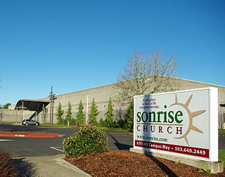
Sonrise Church is a Conservative Baptist church in Hillsboro in the U.S. state of Oregon. Founded in 1980 as Sonrise Baptist Church, the church is located in the Orenco neighborhood and has about 1,200 worshipers at its main campus, a former industrial building.
Orenco Woods Nature Park is a park located in Hillsboro, Oregon, United States. The site was formerly nine-hole Orenco Woods Golf Course in the Orenco neighborhood owned by the Hillsboro Elks. The eastern edge is bounded by Cornelius Pass Road and the tracks for the MAX Blue Line form the northern boundary. Rock Creek flows through the 42-acre (17 ha) site between Orchard Park upstream and Noble Woods Park downstream, with the Rock Creek Trail planned to connect all three parks.

Cornell Road is an east–west street and traffic corridor in the Portland metropolitan area, in Multnomah and Washington counties in the U.S. state of Oregon. It crosses the Tualatin Mountains between the Willamette Valley and the city of Portland on the east and the Tualatin Valley and the city of Hillsboro on the west.

Cornell Creek Park is a city park in Hillsboro, Oregon, United States. Opened in 2016, it has the second dog park in the city after Hondo Dog Park. Located in the Orenco Station neighborhood along Cornell Road, it has just over four acres that is bisected by a small creek.
Orenco station may refer to:

The Forest Grove branch is an abandoned railway line in the state of Oregon, in the United States. It was built by the Oregon Electric Railway and ran 19.1 miles (30.7 km) from Garden Home to Forest Grove via Beaverton and Hillsboro. The MAX Blue Line uses part of the right-of-way between Beaverton and Hillsboro.